
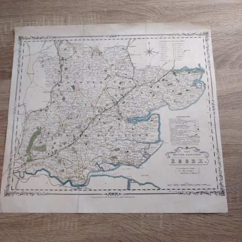
ESSEX ENGLAND 1852 COLLINS & THE BRITISH GAZETTEER ANTIQUE LITHOGRAPHIC MAP
ANTIQUE ORIGINAL LITHOGRAPHIC MAP OF ESSEX ENGLAND 1852
Condition:
--not specified
Ended:Jul 12, 2022 , 7:17AM
Winning bid:
US $30.00
Item specifics
Cartographer/Publisher:
H. G. Collins
Printing Technique:
Lithography
Original/Reproduction:
Antique Original
Format:
Atlas Map
Type:
County Map
Year:
1852
Date Range:
1800-1899
Country/Region:
England, United Kingdom
ESSEX ENGLAND 1852 COLLINS & THE BRITISH GAZETTEER ANTIQUE LITHOGRAPHIC MAP
Description
Essex.
Description: Striking and highly detailed fine original colored lithographic map of Essex, England. The map is filled with excellant topographic details on citiew, towns, rivers, roads, railways and forests. A strapwork title cartouche, a mileage scale, a compass rose and two legend keys adorn the map.
The railways shown include the Witham to Braintree and Maldon lines (opened 1848), the Gt Chesterford to Newmarket line (opened 1848 and closed 1851, although stayed on maps a lot longer), the Marks Tey to Sudbury (opened 1849) and Chapel to Halsted (opened 1860), but not shown are Manningtree to Harwich (opened 1854) or Barking to Tilbury to Mucking (also opened 1854).
The really weird aspect though is the presence of an open canal from Bishops Stortford to Cambridge - an idea that was proposed from 1780 onwards, and finally killed off in c.1820. This was not on the Teesdale 1829 map, but it was on the Coltman 1828 map (a reissue of an 1807 map).
The Gazetteer was first published as the New British Atlas in 1849, and republished as the Gazetteer in 1852, and as Collins' County Atlas of England & Wales in 1857. There is a lot of detail, but essentially it is the Teesdale map of 1829 (which was copied from Rowe 1811).
Date: 1852 ( undated )
Dimension: Paper size approx.: cm 43,4 x 39,9
Condition: Very strong and dark impression on good paper. Map old original colored. Wide top and lower margins. Small lateral margins. Corners partially missing. Small foxing. Small tears restored. Map washed and restored. Map folded. Conditions are as you can see in the images.
All of the maps we sell are ORIGINALS. We guarantee all of our maps to be authentic. We do our best to describe the condition of our maps as accurately as possible. Due to the age and type of paper, some imperfections are to be expected. Please examine the images provided carefully, and if you have any questions please ask and we will be happy to help.
A Certification of Authenticity ( COA ) can be issued on request
I will send you all your item by Registered and Insured Airmal or by TNT/DHL with covering Insurance
If you buy more than one item you have to pay just one only shipping cost
Any map purchased from us may be returend for any reason for a full refund.
Shipping: Customs may be charged on international shipments. All customs charges are the responsiblity of the buyer and are not included in the selling price.
10722
- Product Code: 10722
- Availability: In Stock
-
$0.00
- Ex Tax: $0.00