
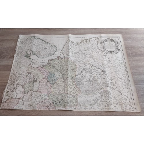
NORTHERN EUROPEAN RUSSIA 1706 GUILLAUME DE L'ISLE ANTIQUE COPPER ENGRAVED MAP
ANTIQUE COPPER ENGRAVED MAP OF NORTHERN RUSSIA 1706
Condition:
--not specified
Ended:Jul 09, 2022 , 7:21AM
Winning bid:
US $54.50
NORTHERN EUROPEAN RUSSIA 1706 GUILLAUME DE L'ISLE ANTIQUE COPPER ENGRAVED MAP
Description
Carte de Moscovie. Dressйe par Guillaume De l'Isle de l'Academie Royale des Sciences. A son excellence Monseigneur Andre Artemonide de Matueof ... Par son tres humble et tres obeiss.t Serviteur De l'Isle. A Paris, Chйz l'Auteur sur le Quai de l'Horloge Avec Privilege du Roy pour 20 ans 1706.
Description: Striking and highly detailed very interesting 1706 copper engraved map of northern part of the European Russian Empire, by Guillaume de l'Isle. Covers Russia, western part of Sweden, Latvia, a bit of Finland and a part of Estonia. The map is filled with excellant topographic details on cities, towns, villages, rivers, lakes, bays, forests, mashes and islands. A large strapwork title cartouche adorns the map.
Date: 1706 ( dated )
Dimension: Paper size approx.: cm 67,9 x 51,9
Condition: Very strong and dark impression on strong paper. Paper with chains and wiremark. Map old original colored. Wide margin to the top. Lower margin missing. Wide right lateral margin. Short left lateral margin, partially missing. Corners partially missing. Paper with foxing and browning. Small tears and holes. Map folded. Conditions are as you can see in the images.
Cartographers: Guillaume De l’Isle (1675 - 1726) was a French cartographer, and arguably the finest mapmaker at the beginning of the eighteenth century. He was the son of Claude De L'Isle (1644 -1720), a Paris-based historian and geographer under Nicholas Sanson, then the leading light of French cartography. He was the chief proponent of the school of 'positive geography' and the primary figure defining the heights of the Golden Age of French Cartography. Guillaume's skill as a cartographer was so prodigious that he drew his first map at just nine years of age. He was tutored by J. D. Cassini in astronomy, science, mathematics and cartography. By applying these diverse disciplines to the vast stores of information provided by 18th century navigators, Guillaume created the technique that came to be known as 'scientific cartography', essentially an extension of Sanson's 'positive geography'. This revolutionary approach transformed the field of cartography and created a more accurate picture of the world. Among Guillaume's many firsts are the first naming of Texas, the first correct map of the Mississippi, the final rejection of the insular California fallacy, and the first identification of the correct longitudes of America. Stylistically De L'Isle also initiated important changes to the medium, eschewing the flamboyant Dutch style of the previous century in favor of a highly detailed yet still decorative approach that yielded map both beautiful and informative. Guillaume was elected to the French Academie Royale des Sciences at 27. Later, in 1718, he was also appointed 'Premier Geographe du Roi', an office created especially for him. De L'Isle personally financed the publication of most of his maps, hoping to make heavy royalties on their sales. Unfortunately he met an untimely death in 1728, leaving considerable debt and an impoverished child and widow. De L'Isle's publishing firm was taken over by his assistant, Phillipe Buache, who would also become his son in law.
10717
- Product Code: 10717
- Availability: In Stock
-
$0.00
- Ex Tax: $0.00