
LIST ON EBAY
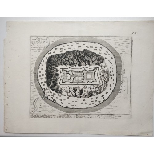
Palanok Castle Mukacheve Ukraine 1695 De Fer Antique Copper Engraved City Map Of The Palanok Castle
Condition:
--not specified
Ended:Jul 10, 2022 , 7:19AM
Winning bid:
US $44.00
Palanok Castle Mukacheve Ukraine 1695 De Fer Antique Copper Engraved City Map
Plan de la Forteresse de Mongats Dessinй sur les lieux Par N... Ingenieur de l'Empereur, et mis au jour Par N. de Fer.
Description: Striking and highly detailed unusual 1705 Nicolas de Fer's copper engraved map featuring an aerial plan of the Palanok Castle or Mukachevo Castle (now Ukraine), an important fortification of the Kingdom of Hungary throughout the centuries.
During the 16th century, Mukacheve (Mongats) became part of the Principality of Transylvania.
The Palanok Castle or Mukachevo Castle (Ukrainian: Замок "Паланок", romanized: Zamok "Palanok"; Hungarian: Munkбcs vбra or Munkбcsi vбr; German: Plankenburg) is a historic castle in the city of Mukacheve in the western Ukrainian oblast (province) of Zakarpattia. The Palanok Castle is delicately preserved, and is located on a former 68 metre high volcanic hill. The castle complex consists of three parts: the high, middle, and low castle.
Source: Nicolas de Fer. Les forces de l' Europe, ou description des principales villes; avec leurs fortifications. ….. Paris, "chez l'auteur" [=Nicolas de Fer, a false imprint], 1695-1696 [printed in Amsterdam, for Pieter Mortier, 1695-ca. 1702].
Date: 1695 ( undated )
Dimension: Paper size approx.: cm 38,1 x 28,6
Condition: Very strong and dark impression on good paper. Paper with chains. Map uncolored. Wide margins. Corners partially missing. Small foxing. Small holes along left lateral margin due to the binding. Small tears. Conditions are as you can see in the images.
Cartographer: Nicholas de Fer (1646-1720) was the son of a map seller, Antoine de Fer, and grew to be one of the most well-known mapmakers in France in the seventeenth century. He was apprenticed at twelve years old to Louis Spirinx, an engraver. When his father died in 1673, Nicholas helped his mother run the business until 1687, when he became the sole proprietor.
His earliest known work is a map of the Canal of Languedoc in 1669, while some of his earliest engravings are in the revised edition of Methode pour Apprendre Facilement la Geographie (1685). In 1697, he published his first world atlas. Perhaps his most famous map is his wall map of America, published in 1698, with its celebrated beaver scene (engraved by Hendrick van Loon, designed by Nicolas Guerard). After his death in 1720, the business passed to his sons-in-law, Guillaume Danet and Jacques-Francois Benard.
Подлинная карта - оттиск с медной пластины - Николя де Фер (Nicolas de Fer) Замок Паланок или Мукачевский замок 1695.
Карта из издания Nicolas de Fer. Les forces de l' Europe, ou description des principales villes; avec leurs fortifications. ….. Paris, "chez l'auteur" [=Nicolas de Fer, a false imprint], 1695-1696 [printed in Amsterdam, for Pieter Mortier, 1695-ca. 1702]
Карта представляет собой впечатляющий вид на замок Мукачево на вершине холма, который в то время был важным оплотом Венгерской империи. Замок окружен рвом с внутренним берегом, защищенным высоким деревянным забором или паланом, за что его часто называют замком Паланок.
В левом верхнем углу картуш с оригинальным названием карты :"'Plan de la Forteresse de Mongats Dessinй sur les lieux Par N... Ingenieur de l'Empereur, et mis au jour Par N. de Fer. "
Замок Паланок или Мукачевский замок (укр. Замок «Паланок»; венг. Munkбcsi vбr; русин. Паланський варош) - замок в городе Мукачево в Закарпатской области Украины, расположенный на горе вулканического происхождения высотой 68 метров. Точная дата основания замка неизвестна, впервые он упоминается в документах, датирующихся XI веком. Замковый комплекс состоит из трех частей: высокого, среднего и низкого замка.
Николя (Николас) де Фер (фр. Nicolas de Fer) - французский гравёр, картограф, издатель, географ.
В 1693 году издал, в частности, виды Каменца-Подольского в серии «Les Forces de l’Europe».
В 1694 году Николя де Фер создал первую карту Парижа карманного размера, предназначенную специально для тех, кто собирался передвигаться по городу пешком. Издание было одновременно и картой и путеводителем.
Им был создан гравированный план Санкт-Петербурга, изданный в 1717 году в Париже по заказу находившегося там в то время царя Петра I.
Был одним из самых активных и влиятельных французских издателей на рубеже XVII и XVIII веков. Важнейшим элементом пропаганды авторитета Бурбонов.
Всего создал более 600 географических карт, в том числе планов и описаний городов Франции, её провинций, а также морских путей.
Его основная работа, «Atlas Curieux» (Атлас Кюри), была издана в Париже в 1700 году.
Размер листа 38,1 x 28,6 см, обратная сторона чистая, в отличном состоянии, издательский фальц.
В отличном состоянии для своего возраста
10704
- Product Code: 10704
- Availability: In Stock
-
$0.00
- Ex Tax: $0.00