
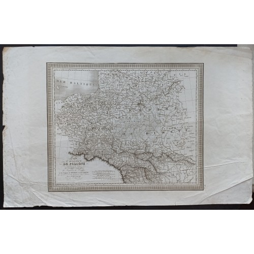
POLAND & LITHUANIA 1849 VIVIEN DE SAINT-MARTIN ANTIQUE ORIGINAL LITHOGRAPHIC MAP
ANTIQUE COPPER ENGRAVED MAP OF POLAND & LITHUANIA 1849
Condition:--
Ended:Jan 09, 2022 , 7:59AM
Winning bid:
US $42.00
Approximately 3,275.88 RUB
POLAND & LITHUANIA 1849 VIVIEN DE SAINT-MARTIN ANTIQUE ORIGINAL LITHOGRAPHIC MAP
Description
Carte du Nouveau Royaume de Pologne relevant de la Russie avec les Parties limitrophes du Royaume de Prusse et des Empires de Russie et d'Autriche qui rйpendent а l'йtendue de l'anciens Roy.me Polonais. Par L. Vivien Gйeographe.
Description: Striking and highly detailed fine unusual 1849 Louis Vivien de Saint-Martin oriignal lithographic map of the Kingdom of Poland. Cover Poland, Lithuania, north-western Germany, partie of Russia, a bit of Moldova and a bit of Romania. The map is filled with excellent topographic details on cities, towns, villages, rivers, mashes, bays, reliefs and islands. A calligraphic title and four mileage scales complete the map.
Source: Louis Vivien de Saint-Martin. Atlas Universel Pour servir а l'Йtude de la Gйographie et de l'Histoire Anciennes et Modernes. Dressй per L. Vivien. Nouvelle Йdition, Paris: Parent Desbarres, Йditeur, 1849.
Date: 1849 ( undated )
Dimension: Paper size approx.: cm 55,4 x 35,1
Condition: Very strong and dark impression on good paper. Map uncolored. Wide margins. Corners partially missing. Small foxing and browning. Small waterstains. Small tears. Conditions are as you can see in the images.
Mapmaker: Louis Vivien, called Vivien de Saint-Martin, (May 17, 1802 - December 26 1896) was a 19th-century French geographer. Prolific and long lived, he had at least a dozen major titles to his credit, including an 1841 history of the French Revolution, an 1844 history of Napoleon, an 1873 history of geography, and (in partnership with Franz Schrader) his Atlas universal de gйographique. Nothing has come down to us of his early years, but he was hailed during his lifetime: he was Honorary President of the Sociйtй de Gйographie de Paris, member of the Royal Academy of Sciences in Berlin, and honorary member of the Royal Academy of Madrid.
Старинная Оригинальная Литографическая Карта - оттиск с медной пластины - Польши и Литвы 1849 года издания известного иследователя Вивьена Де Сент-Мартина (Vivien de Saint-Martin)
Оригинальное название:"Carte du Nouveau Royaume de Pologne relevant de la Russie avec les Parties limitrophes du Royaume de Prusse et des Empires de Russie et d'Autriche qui rйpendent а l'йtendue de l'anciens Roy.me Polonais. Par L. Vivien Gйeographe."
Детализированная оригинальная литографическая карта Королевства Польского от Луи Вивьена де Сен-Мартена 1849 года. На карте изображена Польша, Литва, северо-западную Германия, часть России, небольшая часть Молдовы и часть Румынии. Карта наполнена отличной топографической информацией о городах, поселках, деревнях, реках, болотах, заливах, рельефах и островах. Каллиграфическое название и четыре шкалы , расположенные в левом углу карты, дополняют карту.
Дата: 1849 ( undated )
Размер листа: Paper size approx.: cm 55,4 x 35,1
Состояние: Очень сильный и темный оттиск на хорошей бумаге. Карта неокрашенная. Широкие поля. Углы частично отсутствуют. Небольшие фоксинги. Условия как на фото.
Картограф: Вивьен де Сен-Мартен (Vivien de Saint-Martin), был французским географом 19 века. Плодовитый и долгоживущий, он имел на своем счету по крайней мере дюжину крупных книг, в том числе историю Французской революции 1841 года, историю Наполеона 1844 года, историю географии 1873 года и (в сотрудничестве с Францем Шредером) его универсальный географический атлас .
9472
- Product Code: 9472
- Availability: In Stock
-
$0.00
- Ex Tax: $0.00