
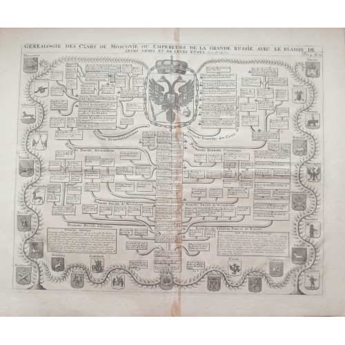
RUSSIA RUSSIAN TZARS & RULERS 1720 CHATELAIN ANTIQUE ORIGINAL GENEALOGICAL CHART
Description
Genealogie des Czars ou Empereurs de Moscovie de la Grande Russie avec le Blason de leurs Armes et de leurs Etats.
Description: Striking and highly detailed very interesting 1720 Henri Abraham Chatelain's copper engraved map featuring the Family trees of the branches of the Tsars, Dukes and Princes with the double headed imperial eagle and various coats of arms. The chart presents explanatory tables.
Atlas Historique
Henri Abraham Chatelain, whose "Atlas Historique" was one of the most expansive Dutch encyclopedias of the age. First published in 1705, Chatelain's Atlas Historique was part of an immense seven-volume encyclopedia. Although the main focus of the text was geography, the work also included a wealth of historical, political, and genealogical information. The text was compiled by Nicholas Gueudeville and Garillon with a supplement by H.P. de Limiers and the maps were engraved by Chatelain, primarily after maps by De L'Isle. The maps were accompanied by information pertaining to cosmography, geography, history, chronology, genealogy, topography, heraldry, and costumes of the world. The maps in the Atlas Historique were mainly based on those of the French cartographer, Guillaume De L’Isle, but were presented by the Chatelains in an encyclopaedic form. The accompanying text is in French and often is printed in two columns on the page with maps and other illustrations interspersed. Each map and table is numbered consecutively within its volume and all maps bear the privileges of the States of Holland and West-Friesland. An ambitious and beautifully-presented work, the Atlas Historique was intended for the general public, fascinated in the early eighteenth century by the recently conquered colonies and the new discoveries. Distant countries, such as the Americas, Africa, the Middle East, Mongolia, China, Japan, Indonesia, etc., take an important place in this work. In addition to the maps, many of which are based on Guillaume De L'Isle, the plates are after the best travel accounts of the period, such as those of Dapper, Chardin, de Bruyn, Le Hay and other. Other sections deal with the history of the european countries, and covers a wide range of subjects including genealogy, history, cosmography, topography, heraldry and chronology, costume of the world, all illustrated with numerous engraved maps, plates of local inhabitants and heraldic charts of the lineages of the ruling families of the time. The maps, prints and tables required to make up a complete set are listed in detail in each volume.
The encyclopaedic nature of the work as a whole is reflected in this six frontispiece. The pages are the work of the celerated mr. Romeijn de Hooghe. and are engraved by J. Goeree, T. Schynyoet and P. luyter. New scholarship has suggested the compiler of the atlas, who is identified on the title as "Mr. C***" not to be Henri Abraham Chвtelain, but Zacharie Chвtelain. (See Van Waning's article in the Journal of the International Map Collectors' Society for persuasive evidence of the latter's authorship).
References: Koeman II, Cha 1-7 (with variant collation, as usual); Phillips Atlases 579; Goffart, Historical Atlases, p. 132; van Waning, "Chatelain's Atlas Historique" in Journal of the International Map Collectors' Society, Spring 2010.
Date: 1720 ( undated )
Dimension: Paper size approx.: cm 54,7 x 45,6
US $157.50
Approximately 12,242.52 RUB
Condition: Very strong and dark impression on good paper. Paper with chains and wiremarks. Plate uncolored. Wide margins. Corners partially missing. Paper with foxing and browning. Plate folded. Conditions are as you can see in the images.
Cartographer: Henri Abraham Chatelain (1684-1743) was a Huguenot pastor of Parisian origins. Chatelain proved a successful businessman, creating lucrative networks in London, The Hague, and then Amsterdam. He is most well known for the Atlas Historique, published in seven volumes between 1705 and 1720. This encyclopedic work was devoted to the history and genealogy of the continents, discussing such topics as geography, cosmography, topography, heraldry, and ethnography. Published thanks to a partnership between Henri, his father, Zacharie, and his younger brother, also Zacharie, the text was contributed to by Nicolas Gueudeville, a French geographer. The maps were by Henri, largely after the work of Guillaume Delisle, and they offered the general reader a window into the emerging world of the eighteenth century.
Guillaume Delisle (Paris, 1675 - 1726), one of the key figures in the development of French cartography, is the son of Claude Delisle, a cartographer, and the half-brother of astronomers Joseph-Nicolas Delisle and Louis de l'Isle de la Croyиre.
While his father has to be given credit for educating Guillaume, the boy showed early signs of being an exceptional talent. He soon contributed to the family workshop by drawing maps for his father's historical works. To perfect his skills, Guillaume Delisle became the student of the astronomer Jean-Dominique Cassini. Early on, he produced high-quality maps, the first being his Carte de la Nouvelle-France et des Pays Voisins in 1696. Delisle's first atlas appeared around 1700, and in 1702 he became a member of the French Acadйmie Royale des Sciences. He taught geography to the young Louis XV, and in 1718 he received the title of Premier Gйographe du Roi. On a commission from Peter the Great, he produced a map of the Caspian Sea, a region barely known. Many of the place names he gave are still in use. His Carte de la Louisiane et du cours du Mississippi (1718) is the first detailed map of this region.
A six-year-long plagiarism trial pits Delisle against Jean-Baptiste Nolin, cartographer. It is Nolin, the real plagiarist, who loses.
Delisle has remained famous for his astronomical-based corrections and the completeness of its topography. The high scientific quality of the work produced by the Delisle family contrasted with the workshop of Sanson. While Sanson knowingly published outdated facts and mistakes, Delisle constantly updated his maps to reflect widening knowledge of the World.
Антикварная гравюра “Генеалогия Русских Царей ” Oк. 1710г. Шатлен.
Гравёр: Анри Шатлен (Henri Abraham Chatelain, 1684-1743)
Год: 1707 - 1719
Техника: гравюра на меди, бумага верже с водяными знаками
Город: Амстердам
Издание: Исторический Атлас или Нововведения в Истории (Atlas historique ou nouvelle introduction a l’Histoire)
Издатель: N.Gueudeville
Размер изображения : 39,0 x47,5
Размер листа 54,7 x 45,6 см
Оригинальное название: Genealogie Des Czars De Moscovie Ou Empereurs De La Grande Russie, Avec Le Blason De Leurs Armes Et De Leurs Etats
Язык: французски
Genealogie des Czars ou Imperials de Moscovie de la Grande Russie avec le Blason de leurs Armes et de leurs Etats.
Гравюра - оттиск с медной доски - Анри Абрахама Шателена 1720 года, на которой изображены родословные ветви правителей Московии и России от Рюрика и до сына Петра I- Алексея Петровича На гравюре изображен двуглавый имперским орел и гербы различных древних русских городов. На схеме представлены пояснительные таблицы.
Издатель: N.Gueudeville
Оригинальное название: Genealogie Des Czars De Moscovie Ou Empereurs De La Grande Russie, Avec Le Blason De Leurs Armes Et De Leurs Etats
Гравюра Анри Абрахам Шатлен из издания Atlas historique ou nouvelle introduction a l’Histoire
(Исторический атлас) - одной из самых обширных голландских энциклопедий своего времени. «Исторический атлас» Шателена, впервые опубликованный в 1705 году, был частью огромной семитомной энциклопедии. Хотя основное внимание в тексте уделялось географии, работа также включала большое количество исторической, политической и генеалогической информации.
Текст был составлен Николасом Гедевилем и Гарильоном с приложением Е.П. де Лимье, а карты были выгравированы Шателеном, прежде всего, по картам Де Лиля. Карты сопровождались информацией, относящейся к космографии, географии, истории, хронологии, генеалогии, топографии, геральдике и костюмам мира. Карты в Atlas Historique были в основном основаны на картах французского картографа Гийома де Лиля.
Амбициозный и красиво оформленный Atlas Historique был предназначен для широкой публики, очарованной в начале восемнадцатого века недавно завоеванными колониями и новыми открытиями.
Картограф Анри Абрахам Шатлен (Henri Abraham Chatelain) (1684-1743) был гугенотским пастором парижского происхождения. Шателен оказался успешным бизнесменом, создав прибыльные филиалы в Лондоне, Гааге, а затем в Амстердаме. Он наиболее известен благодаря Atlas Historique, опубликованному в семи томах между 1705 и 1720 годами. Этот энциклопедический труд был посвящен истории и генеалогии континентов, в нем обсуждались такие темы, как география, космография, топография, геральдика и этнография.
Отличный оттиск на хорошей бумаге. Бумага верже. Издательский фальц. Представляет интерес для музеев.
Экземпляры гравюры находятся в собрании Библиотеки Йельского университета , в Государственной публичной исторической библиотеке России и в Государственном Историческом Музее.
9405
- Product Code: 9405
- Availability: In Stock
-
$0.00
- Ex Tax: $0.00