
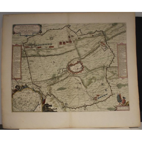
AIRE-SUR-LA-LYS SIEGE OF AIREFRANCE 1649 BLAEU ANTIQUE COPPER ENGRAVED MAP
ANTIQUE ORIGINAL COPPER ENGRAVED MAP SIEGE OF AIRE 1649
Condition:
--not specified
Ended:Jun 11, 2022 , 7:19AM
Winning bid:
US $46.00
AIRE-SUR-LA-LYS SIEGE OF AIREFRANCE 1649 BLAEU ANTIQUE COPPER ENGRAVED MAP
Description
Perfecte afbeeldinge van de stercke stat Ayre oste Arien, aldus belegert en verovert door Louys de dertiende, coning van Vrancryck ende Navarra, in den jare 1641. // Plan d'Ayre avec sez forts, lignes de circonvalations et attaques de la ville, assiйgйe par Loys le 13, roy de France et Navarre, l'an 1641.
Description: Striking and highly detailed fine unusual 1649 Blaeu's copper engraved map of Aire-sur-la-Lys, France, besieged by the French commanded by Charles de la Porte, duc de la Mailleraye on 19 May 1641. The map is filled with excellent topographic details as well as the location of the armies during the Siege. Inset map of Artois region at the lower left quadrant inside a frame-style cartouche embellished with two pwasants, flags & guns. A strapwork title cartouche, a military-themed mileage scale cartouche, a compass rose and two frame-style legend cartouches adorn the map. The map is oriented with south-west to top.
The Siege of Aire is an episode of the Franco-Spanish War. He started onMay 19and led to the seizure of the town of Aire-sur-la-Lys by French troops onJuly 27. But the Spaniards attacked on August 10 and retook the city onDecember 7, 1641.
The Franco-Spanish War was a military conflict between France and Spain which began, in 1635, with French intervention in the Thirty Years' War, in which Spain was already participating. The struggle between the two kingdoms was not suspended by the Treaties of Westphalia which put an end to the Thirty Years' War in 1648, but continued until 1659 with the signing of the Treaty of the Pyrenees.
Date: 1649 ( undated )
Dimension: Paper size approx.: cm 60,8 x 51,9
Condition: Very strong and dark impression on good paper. Paper with chains and wiremarks. Map contemporary handcolored. Wide margins. Corners partially missing. Map with foxing and browning. Small marginal tears. Map folded. Conditions are as you can see in the images.
Mapmaker: The Blaeus: Willem Janszoon, Cornelis & Joan
Willem Jansz. Blaeu and his son Joan Blaeu are the most widely known cartographic publishers of the seventeenth century.
Willem Jansz. (also written Guilielmus Janssonius) = Willem Janszoon Blaeu, was born in Uitgeest (Netherlands), near Alkmaar in 1571. He studied mathematics under Tycho Brahe and learned the theory and practice of astronomical observations and the art of instrument- and globe making.
In 1596 he came to Amsterdam where he settled down as a globe-, instrument- and map-maker. He published his first cartographic work (a globe) in 1599 and probably published his first printed map (a map of the Netherlands) in 1604. He specialized in maritime cartography and published the first edition of the pilot guide Het Licht der Zeevaert in 1608, and was appointed Hydrographer of the V.O.C. (United East India Company) in 1633. After thirty years of publishing books, wall maps, globes, charts and pilot guides, he brought out his first atlas, Atlas Appendix (1630). This was the beginning of the great tradition of atlas-making by the Blaeu's.
In 1618 another mapmaker, bookseller and publisher, Johannes Janssonius established himself in Amsterdam next door to Blaeu's shop. It is no wonder that these two neighbours, who began accusing each other of copying and stealing their information, became fierce competitors who did not have a good word to say about each other. In about 1621 Willem Jansz. decided to put an end to the confusion between his name and his competitor's, and assumed his grandfather's sobriquet, 'blauwe Willem' ('blue Willem'), as the family name; thereafter he called himself Willem Jansz. Blaeu.
Willem Janszoon Blaeu died in 1638, leaving his prospering business to his sons, Cornelis and Joan. Of Cornelis, we only know that his name occurs in the prefaces of books and atlases until c. 1645.
Joan Blaeu, born in Amsterdam, 1596, became partner in his father’s book trade and printing business. In 1638 he was appointed his father’s successor in the Hydrographic Office of the V.O.C. His efforts culminated in the magnificent Atlas Major and the town-books of the Netherlands and of Italy – works unsurpassed in history and in modern times, which gave eternal fame to the name of the Blaeu's.
On February 23, 1672, a fire ruined the business. One year later, Dr Joan Blaeu died. The fire of 1672 and the passing away of the director gave rise to a complete sale of the stock of the Blaeu House. Five public auctions dispersed the remaining books, atlases, copperplates, globes, etc., among many other map dealers and publishers in Amsterdam. The majority was acquired by a number of booksellers acting in partnership.
In the succeeding years, the remaining printing department was left in the hands of the Blaeu family until 1695 when also the inventory of the printing house was sold at a public auction. That meant the end of the Blaeu's as a printing house of world renown.
10366
- Product Code: 10366
- Availability: In Stock
-
$0.00
- Ex Tax: $0.00