
Выставлена на Ss.com
RUSSIA ESTONIA LATVIA 1784 ROBERT DE VAUGONDY & SANTINI UNUSUAL ANTIQUE MAP
ANTIQUE ORIGINAL COPPER ENGRAVED MAP OF EUROPEAN RUSSIA
old times rare books and maps
(20136)
100% positiveSeller's other itemsSeller's other itemsContact seller
US $47.00
RUSSIA ESTONIA LATVIA 1784 ROBERT DE VAUGONDY & SANTINI UNUSUAL ANTIQUE MAP
Description
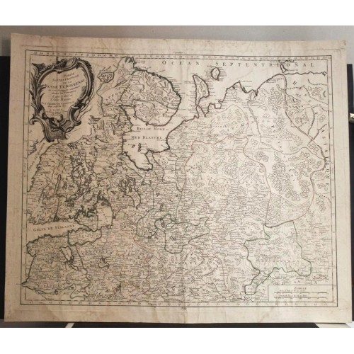
Partie Septentrionale de la Russie Europйenne ou sont distinguйes йxactement toutes les Provinces, d'aprиs le dйtail de l'Atlas Russien. Par le Sr. Robert de Vaugondy fils Geog. ordin? du Roi. A Venise Chez Franзois Santini rue S.te Justine prиs de l'Eglise Chez Mr. Remondini.
Description: Striking and highly detailed interesting 1786 Francesco Santini's edition of the 1753 copper engraved map of northern European Russia by Robert de Vaugondy. It covers the northwestern part of Russia from the Gulf of Finland east to the Ural Mountains and from Finland south to Moscow, including modern day Estonia, Latvia and Finland. This extremely detailed map notes important cities, towns, rivers, mountains, roads and a host of additional topographic features. The Ural Mountains are identified here as ' Monts Payas.'
A beautifully engraved title cartouche and a simple mileage scales cartouche adorn the map.
Date: 1784 ( undated )
Dimension: Paper size approx.: cm 63,9 x 53,8
Condition: Very strong and dark impression on good paper. Paper with chains and wiremarks. Map old original colored. Wide margins. Corners partially missing. Small foxing and browning. Paper with waterstains. Map folded. Conditions are as you can see in the images.
Mapmakers: Gilles (1688 - 1766) and Didier (c. 1723 - 1786) Robert de Vaugondy were map publishers, engravers, and cartographers active in Paris during the mid-18th century. The father and son team were the inheritors to the important Sanson cartographic firm whose stock supplied much of their initial material. Graduating from Sanson's map's Gilles, and more particularly Didier, began to produce their own substantial corpus of work. Vaugondys were well respected for the detail and accuracy of their maps in which they made excellent use of the considerable resources available in 18th century Paris to produce the most accurate and fantasy-free maps possible. The Vaugondys compiled each map based upon their own superior geographic knowledge, scholarly research, the journals of contemporary explorers and missionaries, and direct astronomical observation - moreover, unlike many cartographers of this period, they commonly took pains to reference their source material. Nevertheless, even in 18th century Paris geographical knowledge was severely limited - especially regarding those unexplored portions of the world, including the poles, the Pacific northwest of America, and the interior of Africa and South America. In these areas the Vaugondys, like their rivals De L'Isle and Buache, must be considered speculative geographers. Speculative geography was a genre of mapmaking that evolved in Europe, particularly Paris, in the middle to late 18th century. Cartographers in this genre would fill in unknown areas on their maps with speculations based upon their vast knowledge of cartography, personal geographical theories, and often dubious primary source material gathered by explorers and navigators. This approach, which attempted to use the known to validate the unknown, naturally engendered many rivalries. Vaugondy's feuds with other cartographers, most specifically Phillipe Buache, resulted in numerous conflicting papers being presented before the Academie des Sciences, of which both were members. The era of speculatively cartography effectively ended with the late 18th century explorations of Captain Cook, Jean Francois de Galaup de La Perouse, and George Vancouver. After Didier died, his maps were acquired by Jean-Baptiste Fortin who in 1787 sold them to Charles-Franзois Delamarche (1740 - 1817). While Delamarche prospered from the Vaugondy maps, he also defrauded Vaugondy's window Marie Louise Rosalie Dangy of her inheritance and may even have killed her,
Francesco and Paolo Santini (c.1729-1793)
Franзois [Francesco] Santini (fl. 1776 - 1784) was an Italian cartographer and map publisher based in Venice. He acquired the printing plates of Vaugondy’s Atlas Universel …, a commercial and cartographic success, with widespread influence on mapmakers throughout Europe. Together with his brother Paolo, a Venetian engraver also known for religious prints and cartographic work, he commissioned a new set of plates and reissued the atlas in 1776. Both cartographers were active in roughly the same period and reissued maps of earlier French cartographers ranging from Vaugondy, to Jaillot, to De L'Isle, to D'Anville. Both cartographers also worked with the Venetian Remondini publishing house. The following year, Paolo Santini assigned all his publication rights to M. Remondini, who in 1777 reissued the same atlas but with his name.
Remondini (fl. c. 1657 - 1861) were a family of printers who worked originally based in Bassano del Grappa, near Venice. Giovanni Antonio Remondini (1634-1711), the family patriarch, was born in Padua in 1634. In 1657, he took a home the main square of Bassano where he opened a shop drapes, wool, silk and iron tools. He also sold woodcuts of saints which proved popular with local farmers who believed they bought spiritual protection. When Giovanni died in 1711 his printing business fell into the hands of his son, Joseph Remondini. In 1750 Joseph expended the family business into Venice proper. Having several paper factories established by Giovanni Antonio, the Remondini were in a position to undercut competitors in Venice. The Remondini employed a number of talented engravers, including Paolo Santini, an Abbot who specialized in sacred images as well as cartography. Their corpus includes several beautifully produced atlases, though, cartographically speaking, little in the way of original work. The family fell into decline following the Napoleonic invasions, finally closing their doors in 1861. Most of the Remondini family's work is today preserved in the Museum of Bassano del Grappa and the Piccolo Remondini Museum of Vicenza.
------------
Антикварная карта Северная Часть Европейской России 1784 Роберта де Вогонди (Robert de Vaugondy)
Большая старинная карта - оттиск с медной пластины - Северная Часть европейской России Дидье Робера де Вогонди (1723-1786).
Карта - оттиск с медной платины- из издания Atlas Universel dressйe sur les meuilleures cartes modernes была выполнена картографами Жиля и Дидье Робер де Вогонди (Vaugondy) в 1784 в Париже
Яркое, очень подробное, интересное издание карты северной Европейской части России. Карта является перепечаткой карты Жиля и Дидье Робер де Вогонди 1753 года.
Все надписи на карте на французском языке
Размер листа 63,9 x 53,8
Карта охватывает северо-западную часть России от Финского залива на восток до Уральских гор и от Финляндии на юг до Москвы, включая современные Эстонию, Латвию и Финляндию. На этой чрезвычайно подробной карте отмечены важные города, поселки, реки, горы, дороги и множество дополнительных топографических объектов. Уральские горы обозначены здесь как «Monts Payas».
Карта очень подробная, на ней показаны Финляндия, Лапландия, Эстония, а Москва
14
- Product Code: 6714
- Availability: In Stock
-
$0.00
- Ex Tax: $0.00