
List on Ebay
BOX 21-01-25
описание в картинке
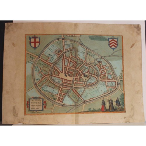
LIER BELGIUM 1588 BRAUN & HOGENBERG UNUSUAL ANTIQUE COPPER ENGRAVED CITY VIEW
ANTIQUE COPPER ENGRAVED CITY VIEW OF LIER BELGIUM 1588
old times rare books and maps
(20087)
100% positiveSeller's other itemsSeller's other itemsContact seller
US $131.00
LIER BELGIUM 1588 BRAUN & HOGENBERG UNUSUAL ANTIQUE COPPER ENGRAVED CITY VIEW
Original Title: Lier - Lira, elegans et amoenum Brabantiae Opp: adeo, Ut multorum huius tractus nobilium in ocio degentium, a curise turba, iundissimus sit recessus. *Lier, a Brabantian town so elegant and delightful that for many of the nobles in this region who can live a life of ease, it is the most pleasant retreat from worries and commotion.)
Description: Striking and highly detailed fine unusual copper engraved map featuring a bird's-eye plan of the city of Lier, Belgium. The view shows the city with his buildings, churches, gardens, streets, town walls, harbor and surrounding landscape. Two strapwork cartouches, two coat of arms and three Inhabitants in their typical dresses adorn the sheet. Latin text on the verso.
This is a bird's-eye view from the south of the town, which has two moats. The inner moat encloses the medieval town. Standing out among the smaller buildings is the church of St Gummarus, a masterpiece of late Gothic Flemish architecture, and the town hall on the Grote Markt, with its Gothic belfry dating from 1369. This town is said to have begun as a hermit's cell established here by a Frankish knight, later known as St Gummarus, who is still the town's patron saint today. In 1212 the town was granted a municipal charter, and a wall was built around it shortly afterwards. Lier was expanded in 1287 and 1389. It largely owed its prosperity to the livestock trade, especially with sheep, but also to the cloth industry.
Braun G. & Hogenberg F. and the Civitates Orbis Terrarum.
The Civitates Orbis Terrarum, or the "Braun & Hogenberg", is a six-volume town atlas and the greatest book of town views and plans ever published: 363 engravings, sometimes beautifully coloured. It was one of the best-selling works in the last quarter of the 16th century.
Georg Braun wrote the text accompanying the plans and views on the verso. A large number of the plates were engraved after the original drawings of Joris Hoefnagel (1542-1600), who was a professional artist.
The first volume was published in Latin in 1572, and the sixth in 1617. Frans Hogenberg created the tables for volumes I through IV, and Simon van den Neuwel created those for volumes V and VI. Other contributors were cartographers Daniel Freese and Heinrich Rantzau. Works by Jacob van Deventer, Sebastian Mьnster, and Johannes Stumpf were also used. Translations appeared in German and French.
Following the original publication of Volume 1 of the Civitates in 1572, seven further editions of 1575, 1577, 1582, 1588, 1593, 1599 and 1612 can be identified. Vol.2, first issued in 1575, was followed by further editions in 1597 and in 1612. The next volumes appeared in 1581, 1588, 1593, 1599 and 1606. The German translation of the first volume appeared from 1574 on, and the French edition from 1575 on.
Several printers were involved: Theodor Graminaeus, Heinrich von Aich, Gottfried von Kempen, Johannis Sinniger, Bertram Buchholtz and Peter von Brachel, who all worked in Cologne.
Date: 1588 ( undated )
Dimension: Paper size approx.: cm 56,2 x 40,3
Condition: Very strong and dark impression on good paper. Paper with chains. Plate old original colored. Wide margins. Corners and margins partially restored with contemporary paper. Small foxing and browning. Plate folded. Conditions are as you can see in the images.
Mapmakers: Georg Braun (also Brunus, Bruin; 1541 – 10 March 1622) was a German geographer, printer and cleric. He spent most of his life as canon and then dean at the church of St Maria ad Gradus in Cologne. His great work was the Civitates orbis terrarum, a magisterial survey of of cities around the world, which took him forty-five years to complete. He oversaw every aspect of the work, from writing the text to hiring artists to engraving the views. As well as producing original material, Braun also drew on the cartography of Jacob van Deventer for cities in the Netherlands, Sebastian Mьnster for Germany, and Heinrich van Rantzau for Scandinavia.
Frans Hogenberg (1535–1590) was a Flemish and German painter, engraver, and mapmaker.
6325
Antique Russian Dresden Christmas Ornament
- Product Code: 6325
- Availability: In Stock
-
$24.99
- Ex Tax: $24.99