
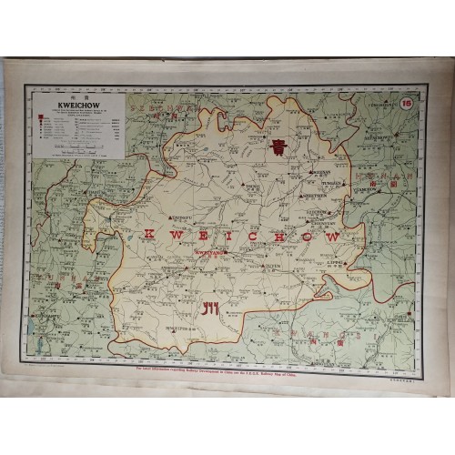
The map titled "Kweichow" was published by the Far Eastern Geographical Establishment and authored by John Edwin Dingle in 1917. It is part of a national atlas published by North-China Daily News & Herald, Ltd. The map is 49 cm wide and 36 cm high, and it is identified by the Pub List No 12042.000 and List No 12042.029.
Composition and Medium:
This is a full-color atlas map, meticulously designed to represent the province of Guizhou (also spelled Kweichow) in China. The map uses a color-coding system, with different shades to distinguish various geographical features. Major cities, towns, and transport routes are prominently marked.
Significant Features:
- Title and Inscriptions: The title "Kweichow" is prominently displayed. The map includes explanations of symbols used, such as capitals, provincial boundaries, and other significant landmarks, in both English and Chinese.
- Landmarks and Cities: Major cities like Guiyang (referred to as Kweiyang) are highlighted. The map also marks important towns such as Anshun, Zunyi, and others.
- Geographical Features: The map shows the province's topography, including rivers and mountain ranges, with a focus on transportation routes.
- Borders: The province's boundaries are clearly delineated, with neighboring provinces like Yunnan, Hunan, and Guangxi identified.
Style and Design:
The map reflects an early 20th-century cartographic style, combining practical geographic information with aesthetic design. The use of color and typography is consistent with the period's focus on clarity and readability, essential for navigation and understanding geographic data.
Subject Matter:
The map focuses on Kweichow (Guizhou province), highlighting its cities, transportation networks, and geographic features. It's a part of a broader atlas that visualizes economic and trade statistics in China, indicating the importance of such maps for understanding regional dynamics during this period.
Cultural and Historical Context:
Created in 1917, this map is part of a national atlas that provides insights into China's geographical and economic landscape during the early 20th century. This period was marked by significant political and social changes in China, including interactions with foreign powers and internal modernization efforts. Maps like this were crucial for navigation, administration, and strategic planning.
Conclusion:
The "Kweichow" map is a detailed representation of Guizhou province, reflecting the cartographic techniques and geopolitical understanding of the early 20th century. Its inclusion in a national atlas underscores its significance in providing insights into China's regional geography and infrastructure at the time.
Author:
Far Eastern Geographical Establishment
Author:
Dingle, John Edwin
Date:1917
Short Title:15. Kweichow, China.
Publisher:North-China Daily News & Herald, Ltd.
Publisher Location:Shanghai
Type:Atlas Map
Obj Height cm:36
Obj Width cm:49
Scale 1:1,676,850
State/Province:Guizhou Sheng (China)
Full Title:15. Kweichow.
Publication Author:Far Eastern Geographical Establishment
Publication Author:Dingle, John Edwin
Pub Date:1917
Pub Title:The New Atlas and Commercial Gazetteer of China. A Work Devoted to Its Geography & Resources and Economic & Commercial Development. Edited by Edwin John Dingle. Containing 25 Bi-lingual maps, with Complete Indexes, and Many Coloured Graphs. Compiled and Translated ... by the Staff of the Far Eastern Geographical Establishment. Shanghai, China: Published by the North-China Daily News & Herald, Ltd.
Pub Note:This volume is a combination of text, maps and graphics. Full color maps. 1917 date based on dates of data (through 1916) and comments by the author in the preface. The atlas contains many interesting visualizations of statistical data on the Chinese economy and trade.
На изображении представлена историческая карта провинции Гуйчжоу (Kweichow) в Китае, относящаяся к началу XX века.
Карта отображает административное деление, ключевые города (например, Гуйян/Kweiyang) и элементы инфраструктуры.
Документ включает пояснения к условным обозначениям на английском и китайском языках.
В нижней части содержится ссылка на специализированные железнодорожные карты Китая того периода.
12251
- Product Code: 12251
- Availability: In Stock
-
$0.00
- Ex Tax: $0.00