
WESTERN HEMISPERE AMERICAS 1852 CRUCHLEY ANTIQUE ORIGINAL LITHOGRAPHIC MAP
ANTIQUE ORIGINAL LITHOGRAPHIC MAP OF WESTERN HEMISPHERE
Condition:
--not specified
Ended:
Sep 15, 2023 22:23:38 PDT
Winning bid:
US $12.50
WESTERN HEMISPERE AMERICAS 1852 CRUCHLEY ANTIQUE ORIGINAL LITHOGRAPHIC MAP
Description
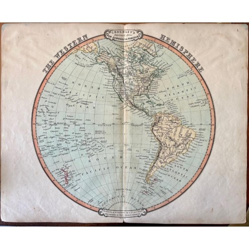
The Western Hemisphere.
Description: Striking and highly detailed fine unusual 1852 George Frederick Cruchley's original colored lithographic map of the Western Hemisphere by George Frederick Cruchley. Includes the whole American Continent, Greenland, New Zealand and Pacific islands (Polynesia). The map is color coded according to continents with countries, cities, rivers and relief is shown by hachures.
Cruchley's General Atlas was unique for its period, employing a vivid color scheme extending even to the oceans, distinctive typography, and various uncommon decorative elements including a peacock feather crown and an imprint medallion, both of which break the printed border. Though many of the maps in this atlas are copyrighted in 1842, the atlas was first published in 1843 from the Cruchley office at 81 Fleet Street, London, and proving popular went through numerous reissues well into the 1850s.
Date: 1852 ( undated )
Dimension: Paper size approx.: cm 47,2 x 38,1
Conditions: Very strong and dark impression. Sheet old original colored. Short margins. Corners partially missing. Small foxing and browning. Small marginal tears. Map folded. Conditions are as you can see in the images.
Cartographer: George Frederick Cruchley (April 23, 1797 - June 16, 1880) was a London based book and map seller active in the middle part of the 19th century. Cruchley began his cartographic career as an apprentice at the venerable Aaroon Arrowsmith firm. Many of Cruchley's earliest maps bear the words 'From Arrowsmith's' on the imprint. In 1844, Cruchley acquired the massive stock of the important early 19th century firm of John Cary. Cruchley published his own maps as well as reissues of Cary's stock well into the 1870s. He is best known for his detailed plans of London, which in recent years have become increasingly scarce and desirable. Cruchley was based in London on 38 Ludgate Street until 1834 when he moved his offices to 81 Fleet Street. Shortly before his death in 1880 Cruchely auctioned (Hodgson's Auctions, Jan 16, 1877) his entire stock. Many of his map plates were thusly acquired by 'Gall and Inglis' who continued the Cruchley tradition well into the early 20th century. Cruchley's son, also George Frederick (1837 - 1882), continued to work as a book and map seller until his death.
-----------
EASTERN HEMISPERE AMERICAS 1852 CRUCHLEY ANTIQUE ORIGINAL LITHOGRAPHIC MAP
ANTIQUE ORIGINAL LITHOGRAPHIC MAP OF EASTERN HEMISPHERE
Condition:
--not specified
Ended:
Sep 15, 2023 22:25:36 PDT
Winning bid:
US $12.50
EASTERN HEMISPERE AMERICAS 1852 CRUCHLEY ANTIQUE ORIGINAL LITHOGRAPHIC MAP
Description
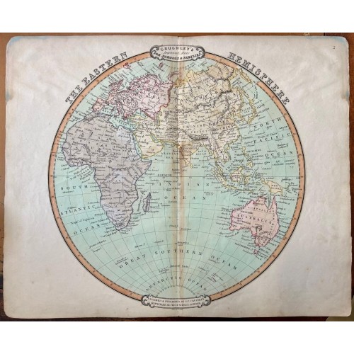
The Eastern Hemisphere.
Description: Striking and highly detailed fine unusual 1852 George Frederick Cruchley's original colored lithographic map of the Eastern Hemisphere by George Frederick Cruchley. Includes the whole Europe, Africa, Asia as well as Australia. The map is color coded according to continents with countries, cities, rivers, lakes, islands and reliefs is shown by hachures.
Cruchley's General Atlas was unique for its period, employing a vivid color scheme extending even to the oceans, distinctive typography, and various uncommon decorative elements including a peacock feather crown and an imprint medallion, both of which break the printed border. Though many of the maps in this atlas are copyrighted in 1842, the atlas was first published in 1843 from the Cruchley office at 81 Fleet Street, London, and proving popular went through numerous reissues well into the 1850s.
Date: 1852 ( undated )
Dimension: Paper size approx.: cm 47 x 38,1
Conditions: Very strong and dark impression. Sheet old original colored. Short margins. Corners partially missing. Small foxing and browning. Small marginal tears. Map folded. Conditions are as you can see in the images.
Cartographer: George Frederick Cruchley (April 23, 1797 - June 16, 1880) was a London based book and map seller active in the middle part of the 19th century. Cruchley began his cartographic career as an apprentice at the venerable Aaroon Arrowsmith firm. Many of Cruchley's earliest maps bear the words 'From Arrowsmith's' on the imprint. In 1844, Cruchley acquired the massive stock of the important early 19th century firm of John Cary. Cruchley published his own maps as well as reissues of Cary's stock well into the 1870s. He is best known for his detailed plans of London, which in recent years have become increasingly scarce and desirable. Cruchley was based in London on 38 Ludgate Street until 1834 when he moved his offices to 81 Fleet Street. Shortly before his death in 1880 Cruchely auctioned (Hodgson's Auctions, Jan 16, 1877) his entire stock. Many of his map plates were thusly acquired by 'Gall and Inglis' who continued the Cruchley tradition well into the early 20th century. Cruchley's son, also George Frederick (1837 - 1882), continued to work as a book and map seller until his death.
12235
- Product Code: 12235
- Availability: In Stock
-
$0.00
- Ex Tax: $0.00