
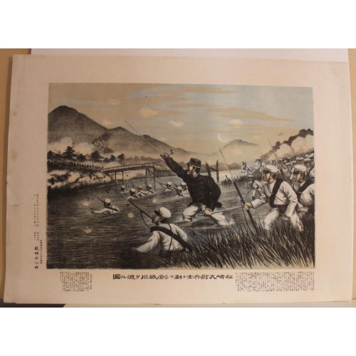
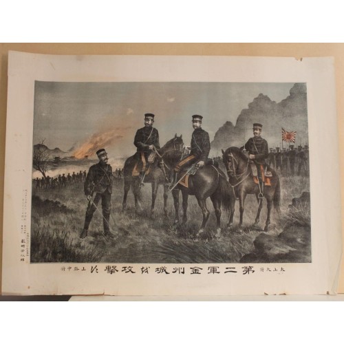
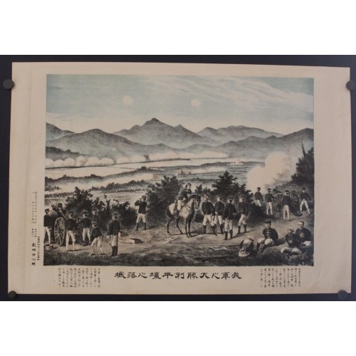
BATTLE OF PYONGYANG KOREA NIGHT SIEGE 1895 YABUSAKI ANTIQUE JAPANESE SCHOOL VIEW
ANTIQUE LITHOGRAPHIC VIEW OF BATTLE OF PYONGYANG KOREA
Condition:
--not specified
“JAPANESE VIEW OF THE BATTLE OF PYONGYANG”
Ended:
Sep 23, 2023 22:17:41 PDT
Winning bid:
US $13.50
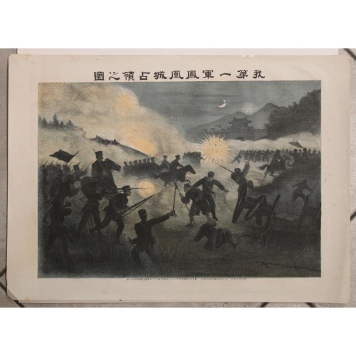
BATTLE OF PYONGYANG KOREA NIGHT SIEGE 1895 YABUSAKI ANTIQUE JAPANESE SCHOOL VIEW
Description
Japenese Shool. - Battle of Pyongyang (Title in Japanese).
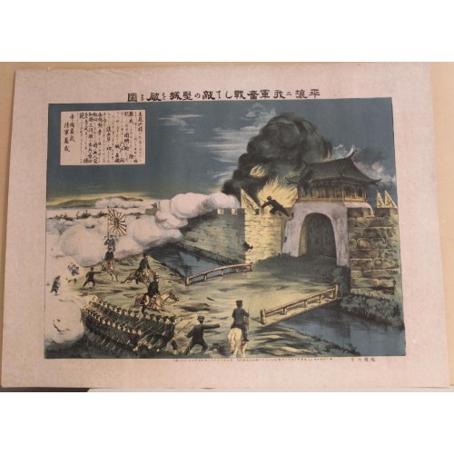
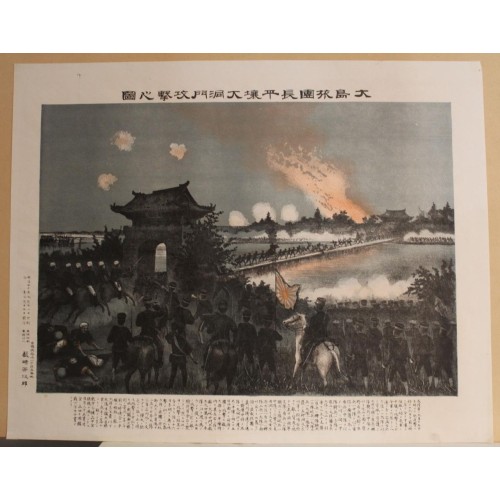
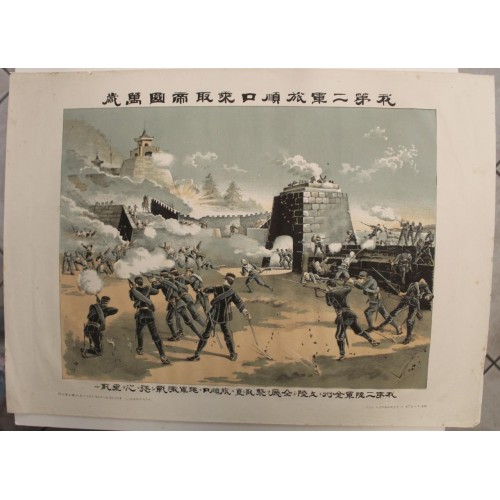
Description: Striking and highly detailed fine unusual original 1895 original colored lithographic print depicting night siege of Pyongyang at the time of the Japanese seizure of Pyongyand, fought on 15-16th September 1894 by the Japanese "Oshima Brigade".
The Battle of Pyongyang (Japanese: ????; Chinese: ????) was the second major land battle of the First Sino-Japanese War. It took place on 15 September 1894 in Pyongyang, Korea between the forces of Meiji Japan and Qing China. It is sometimes referred to archaically in Western sources as the "Battle of Ping-yang". Between 13,000 and 15,000 Chinese troops of the Beiyang Army under overall command of General Ye Zhichao had arrived in Pyongyang on 4 August 1894, and had made extensive repairs to its ancient city walls, feeling itself secure in its superior numbers and in the strength of the defenses.
Prince Yamagata Aritomo's First Army of the Imperial Japanese Army converged on Pyongyang from several directions on 15 September 1894, and in the morning made a direct attack on the north and southeast corners of the walled city under very little cover. The Chinese defense was strong, but was eventually outmaneuvered by an unexpected flanking attack by the Japanese from the rear, costing the Chinese very heavy losses compared to the Japanese.
The First Sino-Japanese War (25 July 1894 – 17 April 1895) was a conflict between the Qing dynasty and Empire of Japan primarily over influence in Korea. After more than six months of unbroken successes by Japanese land and naval forces and the loss of the port of Weihaiwei, the Qing government sued for peace in February 1895.
The war demonstrated the failure of the Qing dynasty's attempts to modernize its military and fend off threats to its sovereignty, especially when compared with Japan's successful Meiji Restoration. For the first time, regional dominance in East Asia shifted from China to Japan; the prestige of the Qing dynasty, along with the classical tradition in China, suffered a major blow. The humiliating loss of Korea as a tributary state sparked an unprecedented public outcry. Within China, the defeat was a catalyst for a series of political upheavals led by Sun Yat-sen and Kang Youwei, culminating in the 1911 Xinhai Revolution.
The war is commonly known in China as the War of Jiawu (Chinese: ????; pinyin: Jiawu Zhаnzheng), referring to the year (1894) as named under the traditional sexagenary system of years. In Japan, it is called the Japan–Qing War (Japanese: ????, Hepburn: Nisshin senso). In Korea, where much of the war took place, it is called the Qing–Japan War (Korean: ????; Hanja: ????).
The print has been published in 1895 by Yoshijiro Yabusaki, of Tsukiji, Tokio.
Date: 1895 ( undated )
Dimension: Paper size approx.: cm 54,8 x 39,4
Condition: Very strong and dark impression on good paper. Map old original colored. Good margins. Small foxing and browning. Small marginal tears. Conditions are as you can see in the images.
Mapmaker: Victor Levasseur (1800 - 1870), an important French engineer, cartographer, and engraver of the mid 19th century, held a number of important cartographically related political and educations posts in France. He is most famous for his Atlas National Illustrй des 86 Dйpartements et des Possessions de La France, a large decorative atlas of France, including his Planisphere and five important continental maps. Levasseur's maps are distinctive for their wide decorative margins containing elaborate depictions of the scenery, peoples, and trade goods of the areas he mapped. Levasseur maps are also known to offer a wealth of statistical data. Until recently, very few Levasseur Atlases migrated out of France where they were mostly used in public libraries and town halls. His work represents some of the last great decorative atlases of the 19th century.
---------
BATTLE OF PYONGYANG KOREA 1895ca YABUSAKI UNUSUAL ANTIQUE JAPANESE SCHOOL VIEW
ANTIQUE LITHOGRAPHIC VIEW OF BATTLE OF PYONGYANG KOREA
Condition:
--not specified
“JAPANESE VIEW OF THE BATTLE OF PYONGYANG”
Ended:
Sep 22, 2023 22:21:37 PDT
Winning bid:
US $46.00
BATTLE OF PYONGYANG KOREA 1895ca YABUSAKI UNUSUAL ANTIQUE JAPANESE SCHOOL VIEW
Description
Japenese Shool. - Battle of Pyongyang (Title in Japanese).
Description: Striking and highly detailed fine unusual original 1895 original colored lithographic print depicting the Japanese seizure of Pyongyand, fought on 15-16th September 1894 by the Japanese "Oshima Brigade".
The Battle of Pyongyang (Japanese: ????; Chinese: ????) was the second major land battle of the First Sino-Japanese War. It took place on 15 September 1894 in Pyongyang, Korea between the forces of Meiji Japan and Qing China. It is sometimes referred to archaically in Western sources as the "Battle of Ping-yang". Between 13,000 and 15,000 Chinese troops of the Beiyang Army under overall command of General Ye Zhichao had arrived in Pyongyang on 4 August 1894, and had made extensive repairs to its ancient city walls, feeling itself secure in its superior numbers and in the strength of the defenses.
Prince Yamagata Aritomo's First Army of the Imperial Japanese Army converged on Pyongyang from several directions on 15 September 1894, and in the morning made a direct attack on the north and southeast corners of the walled city under very little cover. The Chinese defense was strong, but was eventually outmaneuvered by an unexpected flanking attack by the Japanese from the rear, costing the Chinese very heavy losses compared to the Japanese.
The First Sino-Japanese War (25 July 1894 – 17 April 1895) was a conflict between the Qing dynasty and Empire of Japan primarily over influence in Korea. After more than six months of unbroken successes by Japanese land and naval forces and the loss of the port of Weihaiwei, the Qing government sued for peace in February 1895.
The war demonstrated the failure of the Qing dynasty's attempts to modernize its military and fend off threats to its sovereignty, especially when compared with Japan's successful Meiji Restoration. For the first time, regional dominance in East Asia shifted from China to Japan; the prestige of the Qing dynasty, along with the classical tradition in China, suffered a major blow. The humiliating loss of Korea as a tributary state sparked an unprecedented public outcry. Within China, the defeat was a catalyst for a series of political upheavals led by Sun Yat-sen and Kang Youwei, culminating in the 1911 Xinhai Revolution.
The war is commonly known in China as the War of Jiawu (Chinese: ????; pinyin: Jiawu Zhаnzheng), referring to the year (1894) as named under the traditional sexagenary system of years. In Japan, it is called the Japan–Qing War (Japanese: ????, Hepburn: Nisshin senso). In Korea, where much of the war took place, it is called the Qing–Japan War (Korean: ????; Hanja: ????).
The print has been published in 1895 by Yoshijiro Yabusaki, of Tsukiji, Tokio.
Date: 1895 ( undated )
Dimension: Paper size approx.: cm 52,9 x 39,1
Condition: Very strong and dark impression on good paper. Map old original colored. Good margins. Small foxing and browning. Small marginal tears partially repaired on the verso. Conditions are as you can see in the images.
Mapmaker: Victor Levasseur (1800 - 1870), an important French engineer, cartographer, and engraver of the mid 19th century, held a number of important cartographically related political and educations posts in France. He is most famous for his Atlas National Illustrй des 86 Dйpartements et des Possessions de La France, a large decorative atlas of France, including his Planisphere and five important continental maps. Levasseur's maps are distinctive for their wide decorative margins containing elaborate depictions of the scenery, peoples, and trade goods of the areas he mapped. Levasseur maps are also known to offer a wealth of statistical data. Until recently, very few Levasseur Atlases migrated out of France where they were mostly used in public libraries and town halls. His work represents some of the last great decorative atlases of the 19th century.
---
BATTLE OF PYONGYANG KOREA 1895ca YABUSAKI ANTIQUE JAPANESE SCHOOL NIGHT VIEW
ANTIQUE LITHOGRAPHIC VIEW OF BATTLE OF PYONGYANG KOREA
Condition:
--not specified
“JAPANESE VIEW OF THE BATTLE OF PYONGYANG”
Ended:
Sep 22, 2023 22:17:37 PDT
Winning bid:
US $36.00
BATTLE OF PYONGYANG KOREA 1895ca YABUSAKI ANTIQUE JAPANESE SCHOOL NIGHT VIEW
Description
Japenese Shool. - Battle of Pyongyang (Title in Japanese).
Description: Striking and highly detailed fine unusual original 1895 original colored lithographic print depicting the Japanese seizure of Pyongyand, fought on 15-16th September 1894 by the Japanese "Oshima Brigade".
The Battle of Pyongyang (Japanese: ????; Chinese: ????) was the second major land battle of the First Sino-Japanese War. It took place on 15 September 1894 in Pyongyang, Korea between the forces of Meiji Japan and Qing China. It is sometimes referred to archaically in Western sources as the "Battle of Ping-yang". Between 13,000 and 15,000 Chinese troops of the Beiyang Army under overall command of General Ye Zhichao had arrived in Pyongyang on 4 August 1894, and had made extensive repairs to its ancient city walls, feeling itself secure in its superior numbers and in the strength of the defenses.
Prince Yamagata Aritomo's First Army of the Imperial Japanese Army converged on Pyongyang from several directions on 15 September 1894, and in the morning made a direct attack on the north and southeast corners of the walled city under very little cover. The Chinese defense was strong, but was eventually outmaneuvered by an unexpected flanking attack by the Japanese from the rear, costing the Chinese very heavy losses compared to the Japanese.
The First Sino-Japanese War (25 July 1894 – 17 April 1895) was a conflict between the Qing dynasty and Empire of Japan primarily over influence in Korea. After more than six months of unbroken successes by Japanese land and naval forces and the loss of the port of Weihaiwei, the Qing government sued for peace in February 1895.
The war demonstrated the failure of the Qing dynasty's attempts to modernize its military and fend off threats to its sovereignty, especially when compared with Japan's successful Meiji Restoration. For the first time, regional dominance in East Asia shifted from China to Japan; the prestige of the Qing dynasty, along with the classical tradition in China, suffered a major blow. The humiliating loss of Korea as a tributary state sparked an unprecedented public outcry. Within China, the defeat was a catalyst for a series of political upheavals led by Sun Yat-sen and Kang Youwei, culminating in the 1911 Xinhai Revolution.
The war is commonly known in China as the War of Jiawu (Chinese: ????; pinyin: Jiawu Zhаnzheng), referring to the year (1894) as named under the traditional sexagenary system of years. In Japan, it is called the Japan–Qing War (Japanese: ????, Hepburn: Nisshin senso). In Korea, where much of the war took place, it is called the Qing–Japan War (Korean: ????; Hanja: ????).
The print has been published in 1895 by Yoshijiro Yabusaki, of Tsukiji, Tokio.
Date: 1895 ( undated )
Dimension: Paper size approx.: cm 48,8 x 38,8
Condition: Very strong and dark impression on good paper. Map old original colored. Good margins. Small foxing. Conditions are as you can see in the images.
Mapmaker: Victor Levasseur (1800 - 1870), an important French engineer, cartographer, and engraver of the mid 19th century, held a number of important cartographically related political and educations posts in France. He is most famous for his Atlas National Illustrй des 86 Dйpartements et des Possessions de La France, a large decorative atlas of France, including his Planisphere and five important continental maps. Levasseur's maps are distinctive for their wide decorative margins containing elaborate depictions of the scenery, peoples, and trade goods of the areas he mapped. Levasseur maps are also known to offer a wealth of statistical data. Until recently, very few Levasseur Atlases migrated out of France where they were mostly used in public libraries and town halls. His work represents some of the last great decorative atlases of the 19th century.
-----
BATTLE OF PYONGYANG KOREA 1895ca YABUSAKI SCARCE ANTIQUE JAPANESE SCHOOL VIEW
ANTIQUE LITHOGRAPHIC VIEW OF BATTLE OF PYONGYANG KOREA
Condition:
--not specified
“JAPANESE VIEW OF THE BATTLE OF PYONGYANG”
Ended:
Sep 22, 2023 22:15:31 PDT
Winning bid:
US $19.00
BATTLE OF PYONGYANG KOREA 1895ca YABUSAKI SCARCE ANTIQUE JAPANESE SCHOOL VIEW
Description
Japenese Shool. - Battle of Pyongyang (Title in Japanese).
Description: Striking and highly detailed fine unusual original 1895 original colored lithographic print depicting the Japanese seizure of Pyongyand, fought on 15-16th September 1894 by the Japanese "Oshima Brigade".
The Battle of Pyongyang (Japanese: ????; Chinese: ????) was the second major land battle of the First Sino-Japanese War. It took place on 15 September 1894 in Pyongyang, Korea between the forces of Meiji Japan and Qing China. It is sometimes referred to archaically in Western sources as the "Battle of Ping-yang". Between 13,000 and 15,000 Chinese troops of the Beiyang Army under overall command of General Ye Zhichao had arrived in Pyongyang on 4 August 1894, and had made extensive repairs to its ancient city walls, feeling itself secure in its superior numbers and in the strength of the defenses.
Prince Yamagata Aritomo's First Army of the Imperial Japanese Army converged on Pyongyang from several directions on 15 September 1894, and in the morning made a direct attack on the north and southeast corners of the walled city under very little cover. The Chinese defense was strong, but was eventually outmaneuvered by an unexpected flanking attack by the Japanese from the rear, costing the Chinese very heavy losses compared to the Japanese.
The First Sino-Japanese War (25 July 1894 – 17 April 1895) was a conflict between the Qing dynasty and Empire of Japan primarily over influence in Korea. After more than six months of unbroken successes by Japanese land and naval forces and the loss of the port of Weihaiwei, the Qing government sued for peace in February 1895.
The war demonstrated the failure of the Qing dynasty's attempts to modernize its military and fend off threats to its sovereignty, especially when compared with Japan's successful Meiji Restoration. For the first time, regional dominance in East Asia shifted from China to Japan; the prestige of the Qing dynasty, along with the classical tradition in China, suffered a major blow. The humiliating loss of Korea as a tributary state sparked an unprecedented public outcry. Within China, the defeat was a catalyst for a series of political upheavals led by Sun Yat-sen and Kang Youwei, culminating in the 1911 Xinhai Revolution.
The war is commonly known in China as the War of Jiawu (Chinese: ????; pinyin: Jiawu Zhаnzheng), referring to the year (1894) as named under the traditional sexagenary system of years. In Japan, it is called the Japan–Qing War (Japanese: ????, Hepburn: Nisshin senso). In Korea, where much of the war took place, it is called the Qing–Japan War (Korean: ????; Hanja: ????).
The print has been published in 1895 by Yoshijiro Yabusaki, of Tsukiji, Tokio.
Date: 1895 ( undated )
Dimension: Paper size approx.: cm 56,4 x 40,6
Condition: Very strong and dark impression on good paper. Map old original colored. Good margins. Small foxing and browning. Conditions are as you can see in the images.
Mapmaker: Victor Levasseur (1800 - 1870), an important French engineer, cartographer, and engraver of the mid 19th century, held a number of important cartographically related political and educations posts in France. He is most famous for his Atlas National Illustrй des 86 Dйpartements et des Possessions de La France, a large decorative atlas of France, including his Planisphere and five important continental maps. Levasseur's maps are distinctive for their wide decorative margins containing elaborate depictions of the scenery, peoples, and trade goods of the areas he mapped. Levasseur maps are also known to offer a wealth of statistical data. Until recently, very few Levasseur Atlases migrated out of France where they were mostly used in public libraries and town halls. His work represents some of the last great decorative atlases of the 19th century.
--------
BATTLE OF PYONGYANG KOREA 1895ca YABUSAKI ANTIQUE JAPANESE SCHOOL BATTLE VIEW
ANTIQUE LITHOGRAPHIC VIEW OF BATTLE OF PYONGYANG KOREA
Condition:
--not specified
“JAPANESE VIEW OF THE BATTLE OF PYONGYANG”
Ended:
Sep 23, 2023 22:15:34 PDT
Winning bid:
US $13.50
BATTLE OF PYONGYANG KOREA 1895ca YABUSAKI ANTIQUE JAPANESE SCHOOL BATTLE VIEW
Description
Japenese Shool. - Battle of Pyongyang (Title in Japanese).
Description: Striking and highly detailed fine unusual original 1895 original colored lithographic print depicting the Japanese seizure of Pyongyand, fought on 15-16th September 1894 by the Japanese "Oshima Brigade".
The Battle of Pyongyang (Japanese: ????; Chinese: ????) was the second major land battle of the First Sino-Japanese War. It took place on 15 September 1894 in Pyongyang, Korea between the forces of Meiji Japan and Qing China. It is sometimes referred to archaically in Western sources as the "Battle of Ping-yang". Between 13,000 and 15,000 Chinese troops of the Beiyang Army under overall command of General Ye Zhichao had arrived in Pyongyang on 4 August 1894, and had made extensive repairs to its ancient city walls, feeling itself secure in its superior numbers and in the strength of the defenses.
Prince Yamagata Aritomo's First Army of the Imperial Japanese Army converged on Pyongyang from several directions on 15 September 1894, and in the morning made a direct attack on the north and southeast corners of the walled city under very little cover. The Chinese defense was strong, but was eventually outmaneuvered by an unexpected flanking attack by the Japanese from the rear, costing the Chinese very heavy losses compared to the Japanese.
The First Sino-Japanese War (25 July 1894 – 17 April 1895) was a conflict between the Qing dynasty and Empire of Japan primarily over influence in Korea. After more than six months of unbroken successes by Japanese land and naval forces and the loss of the port of Weihaiwei, the Qing government sued for peace in February 1895.
The war demonstrated the failure of the Qing dynasty's attempts to modernize its military and fend off threats to its sovereignty, especially when compared with Japan's successful Meiji Restoration. For the first time, regional dominance in East Asia shifted from China to Japan; the prestige of the Qing dynasty, along with the classical tradition in China, suffered a major blow. The humiliating loss of Korea as a tributary state sparked an unprecedented public outcry. Within China, the defeat was a catalyst for a series of political upheavals led by Sun Yat-sen and Kang Youwei, culminating in the 1911 Xinhai Revolution.
The war is commonly known in China as the War of Jiawu (Chinese: ????; pinyin: Jiawu Zhаnzheng), referring to the year (1894) as named under the traditional sexagenary system of years. In Japan, it is called the Japan–Qing War (Japanese: ????, Hepburn: Nisshin senso). In Korea, where much of the war took place, it is called the Qing–Japan War (Korean: ????; Hanja: ????).
The print has been published in 1895 by Yoshijiro Yabusaki, of Tsukiji, Tokio.
Date: 1895 ( undated )
Dimension: Paper size approx.: cm 54,1 x 38,9
Condition: Very strong and dark impression on good paper. Map old original colored. Good margins. Small foxing and browning. Conditions are as you can see in the images.
Mapmaker: Victor Levasseur (1800 - 1870), an important French engineer, cartographer, and engraver of the mid 19th century, held a number of important cartographically related political and educations posts in France. He is most famous for his Atlas National Illustrй des 86 Dйpartements et des Possessions de La France, a large decorative atlas of France, including his Planisphere and five important continental maps. Levasseur's maps are distinctive for their wide decorative margins containing elaborate depictions of the scenery, peoples, and trade goods of the areas he mapped. Levasseur maps are also known to offer a wealth of statistical data. Until recently, very few Levasseur Atlases migrated out of France where they were mostly used in public libraries and town halls. His work represents some of the last great decorative atlases of the 19th century.
-----
BATTLE OF PYONGYANG JAPANESE GENERALS KOREA 1895ca YABUSAKI ANTIQUE BATTLE VIEW
ANTIQUE LITHOGRAPHIC VIEW OF BATTLE OF PYONGYANG KOREA
Condition:
--not specified
“JAPANESE VIEW OF THE BATTLE OF PYONGYANG”
Ended:
Sep 22, 2023 22:19:39 PDT
Winning bid:
US $31.00
BATTLE OF PYONGYANG JAPANESE GENERALS KOREA 1895ca YABUSAKI ANTIQUE BATTLE VIEW
Description
Japenese Shool. - Battle of Pyongyang (Title in Japanese).
Description: Striking and highly detailed fine unusual original 1895 original colored lithographic print depicting the Japnese Generals, at the time of the Japanese seizure of Pyongyand, fought on 15-16th September 1894 by the Japanese "Oshima Brigade".
The Battle of Pyongyang (Japanese: ????; Chinese: ????) was the second major land battle of the First Sino-Japanese War. It took place on 15 September 1894 in Pyongyang, Korea between the forces of Meiji Japan and Qing China. It is sometimes referred to archaically in Western sources as the "Battle of Ping-yang". Between 13,000 and 15,000 Chinese troops of the Beiyang Army under overall command of General Ye Zhichao had arrived in Pyongyang on 4 August 1894, and had made extensive repairs to its ancient city walls, feeling itself secure in its superior numbers and in the strength of the defenses.
Prince Yamagata Aritomo's First Army of the Imperial Japanese Army converged on Pyongyang from several directions on 15 September 1894, and in the morning made a direct attack on the north and southeast corners of the walled city under very little cover. The Chinese defense was strong, but was eventually outmaneuvered by an unexpected flanking attack by the Japanese from the rear, costing the Chinese very heavy losses compared to the Japanese.
The First Sino-Japanese War (25 July 1894 – 17 April 1895) was a conflict between the Qing dynasty and Empire of Japan primarily over influence in Korea. After more than six months of unbroken successes by Japanese land and naval forces and the loss of the port of Weihaiwei, the Qing government sued for peace in February 1895.
The war demonstrated the failure of the Qing dynasty's attempts to modernize its military and fend off threats to its sovereignty, especially when compared with Japan's successful Meiji Restoration. For the first time, regional dominance in East Asia shifted from China to Japan; the prestige of the Qing dynasty, along with the classical tradition in China, suffered a major blow. The humiliating loss of Korea as a tributary state sparked an unprecedented public outcry. Within China, the defeat was a catalyst for a series of political upheavals led by Sun Yat-sen and Kang Youwei, culminating in the 1911 Xinhai Revolution.
The war is commonly known in China as the War of Jiawu (Chinese: ????; pinyin: Jiawu Zhаnzheng), referring to the year (1894) as named under the traditional sexagenary system of years. In Japan, it is called the Japan–Qing War (Japanese: ????, Hepburn: Nisshin senso). In Korea, where much of the war took place, it is called the Qing–Japan War (Korean: ????; Hanja: ????).
The print has been published in 1895 by Yoshijiro Yabusaki, of Tsukiji, Tokio.
Date: 1895 ( undated )
Dimension: Paper size approx.: cm 54,7 x 39,8
Condition: Very strong and dark impression on good paper. Map old original colored. Good margins. Small foxing. Small marginal tears. Conditions are as you can see in the images.
Mapmaker: Victor Levasseur (1800 - 1870), an important French engineer, cartographer, and engraver of the mid 19th century, held a number of important cartographically related political and educations posts in France. He is most famous for his Atlas National Illustrй des 86 Dйpartements et des Possessions de La France, a large decorative atlas of France, including his Planisphere and five important continental maps. Levasseur's maps are distinctive for their wide decorative margins containing elaborate depictions of the scenery, peoples, and trade goods of the areas he mapped. Levasseur maps are also known to offer a wealth of statistical data. Until recently, very few Levasseur Atlases migrated out of France where they were mostly used in public libraries and town halls. His work represents some of the last great decorative atlases of the 19th century.
----------
BATTLE OF PYONGYANG KOREA 1895 YOSHIJIRO YABUSAKI ANTIQUE JAPANESE SCHOOL VIEW
ANTIQUE LITHOGRAPHIC VIEW OF BATTLE OF PYONGYANG KOREA
Condition:
--not specified
“JAPANESE VIEW OF THE BATTLE OF PYONGYANG”
Ended:
Sep 23, 2023 22:19:37 PDT
Winning bid:
US $13.50
BATTLE OF PYONGYANG KOREA 1895 YOSHIJIRO YABUSAKI ANTIQUE JAPANESE SCHOOL VIEW
Description
Japenese Shool. - Battle of Pyongyang (Title in Japanese).
Description: Striking and highly detailed fine unusual original 1895 original colored lithographic print depicting the Japanese seizure of Pyongyand, fought on 15-16th September 1894 by the Japanese "Oshima Brigade".
The Battle of Pyongyang (Japanese: ????; Chinese: ????) was the second major land battle of the First Sino-Japanese War. It took place on 15 September 1894 in Pyongyang, Korea between the forces of Meiji Japan and Qing China. It is sometimes referred to archaically in Western sources as the "Battle of Ping-yang". Between 13,000 and 15,000 Chinese troops of the Beiyang Army under overall command of General Ye Zhichao had arrived in Pyongyang on 4 August 1894, and had made extensive repairs to its ancient city walls, feeling itself secure in its superior numbers and in the strength of the defenses.
Prince Yamagata Aritomo's First Army of the Imperial Japanese Army converged on Pyongyang from several directions on 15 September 1894, and in the morning made a direct attack on the north and southeast corners of the walled city under very little cover. The Chinese defense was strong, but was eventually outmaneuvered by an unexpected flanking attack by the Japanese from the rear, costing the Chinese very heavy losses compared to the Japanese.
The First Sino-Japanese War (25 July 1894 – 17 April 1895) was a conflict between the Qing dynasty and Empire of Japan primarily over influence in Korea. After more than six months of unbroken successes by Japanese land and naval forces and the loss of the port of Weihaiwei, the Qing government sued for peace in February 1895.
The war demonstrated the failure of the Qing dynasty's attempts to modernize its military and fend off threats to its sovereignty, especially when compared with Japan's successful Meiji Restoration. For the first time, regional dominance in East Asia shifted from China to Japan; the prestige of the Qing dynasty, along with the classical tradition in China, suffered a major blow. The humiliating loss of Korea as a tributary state sparked an unprecedented public outcry. Within China, the defeat was a catalyst for a series of political upheavals led by Sun Yat-sen and Kang Youwei, culminating in the 1911 Xinhai Revolution.
The war is commonly known in China as the War of Jiawu (Chinese: ????; pinyin: Jiawu Zhаnzheng), referring to the year (1894) as named under the traditional sexagenary system of years. In Japan, it is called the Japan–Qing War (Japanese: ????, Hepburn: Nisshin senso). In Korea, where much of the war took place, it is called the Qing–Japan War (Korean: ????; Hanja: ????).
The print has been published in 1895 by Yoshijiro Yabusaki, of Tsukiji, Tokio.
Date: 1895 ( undated )
Dimension: Paper size approx.: cm 54,4 x 36,6
Condition: Very strong and dark impression on good paper. Map old original colored. Good margins. Small foxing and browning. Conditions are as you can see in the images.
Mapmaker: Victor Levasseur (1800 - 1870), an important French engineer, cartographer, and engraver of the mid 19th century, held a number of important cartographically related political and educations posts in France. He is most famous for his Atlas National Illustrй des 86 Dйpartements et des Possessions de La France, a large decorative atlas of France, including his Planisphere and five important continental maps. Levasseur's maps are distinctive for their wide decorative margins containing elaborate depictions of the scenery, peoples, and trade goods of the areas he mapped. Levasseur maps are also known to offer a wealth of statistical data. Until recently, very few Levasseur Atlases migrated out of France where they were mostly used in public libraries and town halls. His work represents some of the last great decorative atlases of the 19th century.
--
12231
- Product Code: 12231
- Availability: In Stock
-
$0.00
- Ex Tax: $0.00