
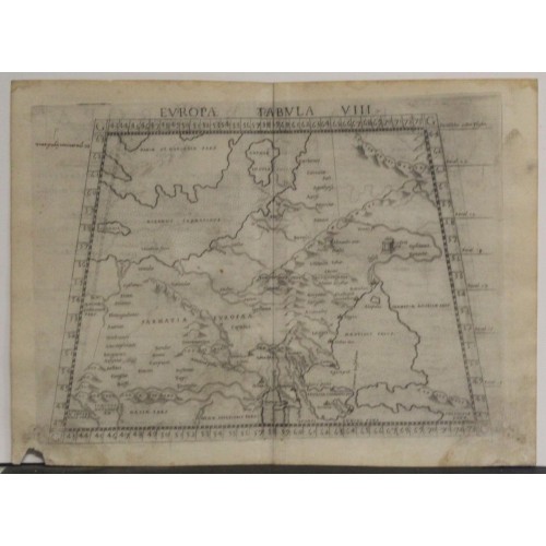
POLAND & LITHUANIA 1574 RUSCELLI & PTOLEMY UNUSUAL ANTIQUE COPPER ENGRAVED MAP
ANTIQUE COPPER ENGRAVED MAP OF POLAND & LITHUANIA 1574
old times rare books and maps
(20116)
100% positiveSeller's other itemsSeller's other itemsContact seller
US $68.00
POLAND LITHUANIA LATVIA 1574 MALOMBRA/PTOLEMY SCARCE ANTIQUE COPPER ENGRAVEDMAP
Description
Europa Tabula VIII.
Description: Striking and highly detailed very interesting 1574 Girolamo Ruscelli’s copper engraved map in trapezoid form is from his work La Geografia di Claudio Tolomeo Alessandrino. Based on the work of Ptolemy, it depicts portions of Eastern Europe from just west of the Vistula River in Poland including a portion of Germany.
The map covers a vast territory through the modern day countries of Scandinavia, the Swedish island of Gotland (Gothia Insula), Poland, Lithuania, Latvia, Ukraine including the Crimea, and Russia. It also includes the Sea of Azov and Sarmatia to the east of it, and the northern shores of the Black Sea, including the legendary kingdom of Colchis of Golden Fleece renown.
The topography is inaccurate in places, with the Ural Mountains positioned to the west of their true geographic location. Two interesting ancient historical altars are depicted, one to Alexander the Great and the other to Julius Caesar. Mountain ranges such as the Carpathians, and river systems are clearly denoted. All the seas are stippled. There is descriptive text in Italian on the verso.
Source: La Geografia di Claudio Tolomeo alessandrino giа tradotta di greco in italiano da M. Giero. Ruscelli & hora in questa nuova editione da m. Gio. Malombra ricorretta & purgata d'infiniti errori con un discorso di m. Gioseppo Moleto, in Venetia, appresso Giordano Ziletti, 1574.
Date: 1574 ( undated )
Dimension: Paper size approx.: cm 29,6 x 21,6
Condition: Very strong and dark impression on good paper. Paper with chains. Sheet uncolored. Wide margins. Small foxing and browning. Map folded. Conditions are as you can see in the images.
Cartographers: Girolamo Ruscelli (1500-1566) was a cartographer, humanist, and scholar from Tuscany. Ruscelli was a prominent writer and editor in his time, writing about a wide variety of topics including the works of Giovanni Boccaccio and Francesco Petrarch, Italian language, Italian poetry, medicine, alchemy, and militia. One of his most notable works was a translation of Ptolemy’s Geographia which was published posthumously.
There is limited information available about Ruscelli’s life. He was born in the Tuscan city of Viterbo to a family of modest means. He was educated at the University of Padua and moved between Rome and Naples until 1548, when he moved to Naples to work in a publishing house as a writer and proofreader. He remained in the city until his death in 1566.
Claudius Ptolemy (90 A.D.-168 A.D.) was a celebrated astronomer, mathematician, and geographer who lived in Alexandria in the 2nd century AD. Although his thinking influenced contemporary Arab geographers, little was known of his work in the West until manuscripts from Constantinople reached Italy in about 1400. These manuscripts were written in Greek and contained the names of every city, island, mountain and river known to the many travellers interviewed by Ptolemy. In addition, the latitude and longitude of each of the resulting eight thousand locations were also recorded. They were translated into Latin by 1401 and appeared in print by 1475. The earliest Byzantine manuscript maps, drawn by analysing the Ptolemy figures, date from the twelfth century. A number of hand-drawn copies were made in Italy throughout the early fifteenth century to accompany Ptolemys text.
Ptolemy stressed the importance of accurate observations in order to calculate latitude and longitude, and laid down the principals of systematic cartography that remain to this day. Obviously there are many errors in Ptolemys maps, due to the limited extent of basic geographic information at that time and the lack of a method of determining accurate longitudes. Judged by modern standards, the basic shortcoming of the Ptolemy world map is the small area it portrays. The Mediterranean is fairly well depicted, but is greatly exaggerated in length (Longitudinally). The effect of this, combined with Ptolemys disregard for Eratosthenes extremely accurate estimate of the earths circumference (c. 200 B.C.) and the use of a Posidonius much smaller flawed estimate (c.50 B.C.) implied a much shorter distance across that part of the unknown earths surface not drawn on the map. Columbus and his contemporaries based their exploratory ventures on Ptolemys calculations and, like him, had no idea of the vast New World to the west, interposed between Europe and Asia.
Work on the first printed atlas from the text of Ptolemy was started in 1473 and finally published in 1478. A crude copy of this atlas was produced and published by some dissident workers in 1477 in order to be first. However, the plates for the 1478 were done prior to the pirated issue and thus the 1478 atlas holds the title of the first Atlas of the world. There are very few surviving examples of this atlas and individual maps.
Translator: Giovanni Malombra (circa 1520 – circa 1580), floruit 1574, also known as Zuan Malombra and Zuanne Malombra, Italian geographer and translator.
12176
- Product Code: 12176
- Availability: In Stock
-
$0.00
- Ex Tax: $0.00