
Между двух кусков оргалита
Можно выставить на мешке
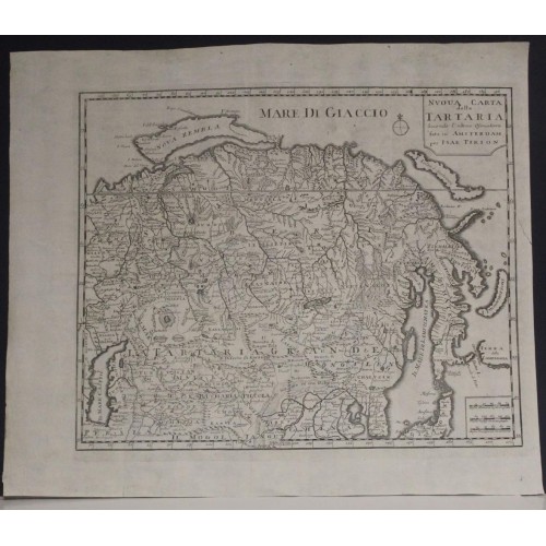
RUSSIA TARTARY CHINA 1736 ISAAK TIRION ANTIQUE UNUSUAL COPPER ENGRAVED MAP
ANTIQUE COPPER ENGRAVED MAP OF TARTARY RUSSIA & CHINA
old times rare books and maps
(20116)
100% positiveSeller's other itemsSeller's other itemsContact seller
US $37.00
RUSSIA TARTARY CHINA 1736 ISAAK TIRION ANTIQUE UNUSUAL COPPER ENGRAVED MAP
Description
Nuova Carta della Tartaria Secondo l'Ultime Oservationi fata in Amsterdam per Isak Tirion.
Description: Striking and highly detailed fine unusual 1736 Isaac Tirion's copper engraved map of Tartary, or Russia in Asia. This is one of the few obtainable derivative maps to be based upon the little-known but groundbreaking cartography of Phillip Johann von Strahlenberg, created while he was a prisoner in Tobolsk.
The Source
Tirion's work, presented as 'drawn from the latest observations,' has often been ascribed, likely in error, to Guillaume De l'Isle. This map does not at all resemble De l'Isle's map of the same area. Rather, Tirion's 1732 original was indeed drawn from the truly state-of-the-art 1730 map of Phillip Johann von Strahlenberg. A cursory comparison between this map, those of De l'Isle, and the 1730 Strahlenberg makes the connection plain, on the strength of its depiction of the north and east coastlines. The shared detail of the Mare/Lacus Kamischnor (probably the wetlands of Kazakhstan and Uzbekistan) and the identical treatment of Lake Baikal on both maps confirms the connection. Tirion's choice of source was wise: Strahlenberg's 1730 map was the largest, most groundbreaking, and unique map of Russia to appear in the first half of the 18th century. Its presentation of a potential Northeast Passage, and its pre-Bering mapping of the Bering Strait made it among the most compelling works of the mapping of Asian Russia. Strahlenberg's enforced proximity to his subject (owing to his decades as a prisoner of war in Tobolsk) made his work all the more authoritative, improving sharply on the work of the area produced in the 17th century by Witsen, and the early 18th-century efforts of De l'Isle.
The Dezhnev Anomaly or Witsen's Peninsula
Nicolas Witsen's mapping does not disappear in Strahlenberg's work; for example, Witsen's Peninsula - here named 'Capo Suetoinos' - can be seen extending from Siberia's northeastern coast just south of the Kolyma River.
The Mysterious Island of Puchochotski
One of the hallmarks of the Strahlenberg map appearing here is Puchochotski Island - the crescent shaped island at the easternmost extreme of this map. This island is mapped on only a few obscure Russian manuscripts of the early eighteenth century and was probably related to the discoveries of Petr Popov, who was sent from Anadyrsk to explore the Chukchi Peninsula in 1711. Popov returned with indigenous reports of a large island one day's voyage east of the Peninsula - without question representing Chukchi knowledge of the Behring Strait and Alaska: thus - Puchochotski Island is actually one of the first depictions of Alaska, based on native report.
An Unsung Map
Leo Bagrow had lamented in Imago Mundi that:
It is to be regretted that Strahlenberg's map has so far not been studied to any large extent. After Remezov, it is the second most important source of historical geographical information about Siberia. Yet it did not have a great influence on maps of the following period and, in a way, stands apart.
And yet, here in Tirion's map and its Italian copy, is evidence that Strahlenberg's cartography was in fact disseminated and presented as 'the latest observations,' albeit failing to apply the long-suffering Strahlenberg's name to any of it.
Date: 1736 ( undated )
Dimension: Paper size approx.: cm 40,7 x 34,8
Condition: Very strong and dark impression on good paper. Paper with chains and wiremarks. Map uncolored. Wide top and lower margins. Short right lateral margin. Wide left lateral margin. Small tear at the right side repaired on the verso. Map folded. Conditions are as you can see in the images.
Mapmakers: Isaak Tirion (1705 - 1765) was a Dutch publisher in Amsterdam. Born in Utrecht, Tirion quickly rose to prominence by publishing pamphlets, historical works, and most importantly, maps and atlases. He produced several atlases and Dutch town plans. His maps are mainly based on those of Guillaume de l'Isle. Tirion eventually relocated his printing house to the prestigious Kalverstraat. In his long career, he produced eight atlases in multiple editions, some of which were published posthumously until about 1784.
Philipp Johann von Strahlenberg (October 6, 1677 - September 7, 1747), aka Philip Johan Tabbert, was a Swedish army officer of Germanic descent. Strahlenberg was born in the Hanseatic town Stralsund, now Pomerania, Germany, but then part of Sweden. Strahlenberg joined the Swedish army in 1694, being promoted to Captain in 1703. When he was ennobled in 1707, he took the name Strahlenberg. During the Great Northern War (1700 - 1721) between Russia and Sweden, Strahlenberg was captured and sent to Tobolsk, where he lived the commodious life of a noble prisoner of war from 1711 to 1721. During this time, he developed a fascination with the the geography of Siberia and studied the anthropology, languages, and customs of its indigenous peoples. He also worked as an assistant to the German explorer and naturalist Daniel Gottlieb Messerschmidt (1685-1735), who was then working for Peter the Great. Along with fellow Swedish prisoner, Johan Anton von Matйrn, Strahlenberg dedicated himself to the composition of a large new map of Russia. Strahlenberg recommended that the Ural Mountains serve as the eastern borders of the European continent, an idea that was later approved by the Tsar. He returned to Sweden in 1722, and in 1730 he published an important book about Siberia, Das Nord- und Ostliche Theil von Europa und Asia (North and Eastern Parts of Europe and Asia), and its accompanying map.
12166
- Product Code: 12166
- Availability: In Stock
-
$0.00
- Ex Tax: $0.00