
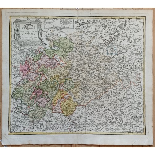
Яркая цветная большая антикварная карта ок. 1735 года с изображением Саксонии немецкого гравера и картографа, основателя картографического издательства в Нюрнберге, ведущего издателя карт в Германии в XVIII веке, Иоганна Баптиста Хоманна (Johann Baptist Homann) Отличный подарок солидному человеу!!
Гравюра на меди (офорт, резец), бумага верже, акварель.
В левом верхнем углу роскошный титульный картуш, с оригинальным названием карты.
Год: 1735 (недатированная)
Техника: гравюра на стали, бумага, ручная акварельная раскраска
Страна: Франция
Размер листа (см): 52 x 60
Размер изображения (см): 49,5 x 56,5
Verso blanc.
Оригинальное название: "Circuli Super Saxoniae pars Meridionalis sive Ducatus...Homannianos"
Иоанн Баптист Хоманн (Johann Baptist Homann, 1664-1724) - немецкий гравёр и картограф, основатель картографического издательства в Нюрнберге, ведущего издателя карт в Германии в XVIII веке. В 1702 году основал картографическое издательство «Ioh. Baptisto Homanno». В 1715 году Хоманн был избран членом Прусской академии наук в Берлине и назначен главным географом Священной Римской Империи при дворе императора Карла VI. Иоанн Баптист Хоманн состоял в переписке с Петром I и Яковом Брюсом, а в 1722 году получил патент русского агента в Нюрнберге. Издательство перешло к его сыну Кристофу после смерти Иоганна в 1724 году. Кристоф умер в 1730 году, в возрасте всего 27 лет, и дело было унаследовано последующими наследниками Хоманна. Это изменило название издательства, которое было известно как Homann Erben, или “наследники Хоманна“. Издательство продолжало свою деятельность до 1848 года.
Карта имеет историко-географическое, культурное и художественное значение, её отличает прекрасная техника гравирования, эффектность, особая декоративность. Прекрасное коллекционное состояние, оттиск яркий и четкий.
Кабинетный формат, представляет интерес для музеев, ценителей истории, декораторов.
Старинная карта обладает антикварной, художественной и коллекционной ценностью, и будет великолепным подарком коллекционеру, неповторимым украшением интерьера.
? 15000 rub
# 11685
-------------------
1735 J B Homann Large Antique Map of Old Saxony, Germany - Berlin to Prague
Cartographer : Johann Baptist Homann
Title : Circuli Super Saxoniae pars Meridionalis sive Ducatus...Homannianos
Date : 1735
Condition: (A+) Fine Condition
Ref # : 30832
Size : 23in x 19in (600mm x 520mm)
Description:
This large original hand coloured copper plate engraved antique map of the Saxony region of central Germany. The map stretches from Berlin in the north to Prague in the Czech Republic to the south, by J B Homann was published by the Homann Heirs firm in 1735. (Ref: Tooley; M&B)
General Definitions:
Paper thickness and quality: - Heavy and stable
Paper color : - off white
Age of map color: - Original
Colors used: - Blue, pink, red, green, yellow
General color appearance: - Authentic
Paper size: - 23in x 19in (600mm x 520mm)
Plate size: - 24in x 19 1/2in (565mm x 495mm)
Margins: - Min 1in (25mm)
Imperfections:
Margins: - None
Plate area: - None
Verso: - None
Background:
Saxony is a landlocked federal state of Germany, bordering the federal states of Brandenburg, Saxony Anhalt, Thuringia, and Bavaria, as well as the countries of Poland and the Czech Republic.
The history of the state of Saxony spans more than a millennium. It has been a medieval duchy, an electorate of the Holy Roman Empire, a kingdom, and twice a republic.
The area of the modern state of Saxony should not be confused with Old Saxony, the area inhabited by Saxons. Old Saxony corresponds roughly to the modern German states of Lower Saxony, Saxony-Anhalt, and the Westphalian part of North Rhine-Westphalia.
The territory of the Free State of Saxony became part of the Holy Roman Empire by the 10th century, when the dukes of Saxony were also kings (or emperors) of the Holy Roman Empire, comprising the Ottonian, or Saxon, Dynasty. Around this time, the Billungs, a Saxon noble family, received extensive fields in Saxony. The emperor eventually gave them the title of dukes of Saxony. After Duke Magnus died in 1106, causing the extinction of the male line of Billungs, oversight of the duchy was given to Lothar of Supplinburg, who also became emperor for a short time.
In 1137, control of Saxony passed to the Guelph dynasty, descendants of Wulfhild Billung, eldest daughter of the last Billung duke, and the daughter of Lothar of Supplinburg. In 1180 large portions west of the Weser were ceded to the Bishops of Cologne, while some central parts between the Weser and the Elbe remained with the Guelphs, becoming later the Duchy of Brunswick-Lьneburg. The remaining eastern lands, together with the title of Duke of Saxony, passed to an Ascanian dynasty (descended from Eilika Billung, Wulfhild\\\\\\\'s younger sister) and were divided in 1260 into the two small states of Saxe-Lauenburg and Saxe-Wittenberg. The former state was also named Lower Saxony, the latter Upper Saxony, thence the later names of the two Imperial Circles Saxe-Lauenburg and Saxe-Wittenberg. Both claimed the Saxon electoral privilege for themselves, but the Golden Bull of 1356 accepted only Wittenberg\\\\\\\'s claim, with Lauenburg nevertheless continuing to maintain its claim. In 1422, when the Saxon electoral line of the Ascanians became extinct, the Ascanian Eric V of Saxe-Lauenburg tried to reunite the Saxon duchies.
However, Sigismund, King of the Romans, had already granted Margrave Frederick IV the Warlike of Meissen (House of Wettin) an expectancy of the Saxon electorate in order to remunerate his military support. On 1 August 1425 Sigismund enfeoffed the Wettinian Frederick as Prince-Elector of Saxony, despite the protests of Eric V. Thus the Saxon territories remained permanently separated. The Electorate of Saxony was then merged with the much bigger Wettinian Margraviate of Meissen, however using the higher-ranking name Electorate of Saxony and even the Ascanian coat-of-arms for the entire monarchy. Thus Saxony came to include Dresden and Meissen. In the 18th and 19th centuries Saxe-Lauenburg was colloquially called the Duchy of Lauenburg, which in 1876 merged with Prussia as the Duchy of Lauenburg district.
Saxony-Wittenberg, in modern Saxony-Anhalt, became subject to the margravate of Meissen, ruled by the Wettin dynasty in 1423. This established a new and powerful state, occupying large portions of the present Free State of Saxony, Thuringia, Saxony-Anhalt and Bavaria (Coburg and its environs). Although the centre of this state was far to the southeast of the former Saxony, it came to be referred to as Upper Saxony and then simply Saxony, while the former Saxon territories were now known as Lower Saxony.
In 1485, Saxony was split. A collateral line of the Wettin princes received what later became Thuringia and founded several small states there (see Ernestine duchies). The remaining Saxon state became still more powerful and was known in the 18th century for its cultural achievements, although it was politically weaker than Prussia and Austria, states which oppressed Saxony from the north and south, respectively.
Between 1697 and 1763, the Electors of Saxony were also elected Kings of Poland in personal union.
In 1756, Saxony joined a coalition of Austria, France and Russia against Prussia. Frederick II of Prussia chose to attack preemptively and invaded Saxony in August 1756, precipitating the Third Silesian War (part of the Seven Years\\\\\\\' War). The Prussians quickly defeated Saxony and incorporated the Saxon army into the Prussian army. At the end of the Seven Years\\\\\\\' War, Saxony recovered its independence in the 1763 Treaty of Hubertusburg.
? 15000 rub
# 11685
11685
- Product Code: 11685
- Availability: In Stock
-
$0.00
- Ex Tax: $0.00