
List on Ebay
BOX 21-01-25
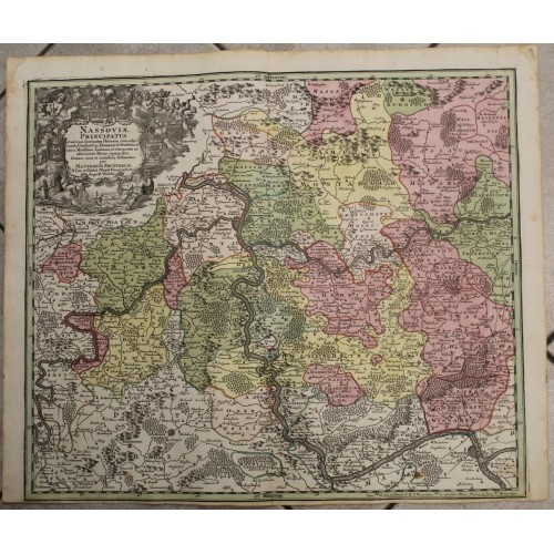
DUCHY OF NASSAU GERMANY 1740 SEUTTER UNUSUAL ANTIQUE COPPER ENGRAVED MAP
ANTIQUE
COPPER ENGRAVED MAP OF THE DUCHY OF NASSAU 1740
old times rare books and maps
old times rare books and maps
(19538)
100% positiveSeller's other itemsSeller's other itemsContact seller
US $27.00
DUCHY OF NASSAU GERMANY 1740 SEUTTER UNUSUAL ANTIQUE COPPER ENGRAVED MAP
Description
Nassoviж Principatus et ad eum spectantes Ditiones cum adjacentibus Comitatibus Dominiis et Praefecturis intra Mosellam, Lahnum et citeriorem ac ulteriorem Rheni ripam sites summa cura et industria delineatus per Matthaeum Seutterum S. Cжs. et Cathol. Majest. Geographum August. Vindelic.
Description: Striking and highly detailed fine unusual 1740 copper engraved map of the Duchy of Nassau, Germany. Covers the region between the Rhein & Moselle Rivers. The map is filled with excellant topographic details on cities, towns, rivers, reliefs and forests. A large figurate title cartouche bearing figures & six Armorials adorns the map.
The Duchy of Nassau (German: Herzogtum Nassau) was an independent state between 1806 and 1866, located in what is now the German states of Rhineland-Palatinate and Hesse. It was a member of the Confederation of the Rhine and later of the German Confederation. Its ruling dynasty, now extinct, was the House of Nassau. The duchy was named for its historical core city, Nassau, although Wiesbaden rather than Nassau was its capital. In 1865, the Duchy of Nassau had 465,636 inhabitants. After being occupied and annexed into the Kingdom of Prussia in 1866 following the Austro-Prussian War, it was incorporated into the Province of Hesse-Nassau. The area today is a geographical and historical region, Nassau, and Nassau is also the name of the Nassau Nature Park within the borders of the former duchy.
Today, the Grand Duke of Luxembourg still uses "Duke of Nassau" as his secondary title, and "Prince" or "Princess of Nassau" is used as a title by other members of the grand ducal family. Nassau is also part of the name of the Dutch royal family, which styles itself Orange-Nassau.
Date: 1740 ( undated )
Dimension: Map size approx.: cm 62,8 x 52,8
Condition: Very strong and dark impression on good paper. Paper with chains and wiremarks. Map old original colored. Wide margin to the top. Lower margin missing. Wide lateral margins. Corners partially missing. Small foxing and browning. Map folded. Conditions are as you can see in the images.
Mapmakers: MatthaЁus Seutter (1678 - 1757) was one of the most important and prolific German map publishers of the 18th century. Seutter was born the son of a goldsmith but apprenticed as a brewer. Apparently uninspired by the beer business, Seutter abandoned his apprenticeship and moved to Nuremberg where he apprenticed as an engraver under the tutelage of the prominent J. B. Homann. Sometime in the early 1700s Seutter left Homann to return to Augsburg, where he worked for the prominent art publisher Jeremiad Wolff (1663 - 1724), for whom he engraved maps and other prints. Sometime around 1717 he established his own independent cartographic publishing firm in Augsburg. Though he struggled in the early years of his independence, Seutter's engraving skill and commitment to diversified map production eventually attracted a substantial following. Most of Seutter's maps are heavily based upon, if not copies of, earlier work done by the Homann and De L'Isle firms. Nonetheless, by 1731/32 Seutter was one of the most prolific publishers of his time and was honored by the German Emperor Karl VI who gave him the title of Imperial Geographer, after which most subsequent maps included the Avec Privilege designation. Seutter continued to publish until his death, at the height of his career, in 1757. Seutter had two engraver sons, Georg MatthaЁus Seutter (1710 - 173?) and Albrecht Carl Seutter (1722 - 1762). Georg MatthaЁus quit the business and relocated to Woehrdt in 1729 (and probably died shortly thereafter), leaving the family inheritance to his wastrel brother Albrecht Carl Seutter, who did little to advance the firm until in own death in 1762. Following Albrecht's death, the firm was divided between the established Johann Michael Probst (1727 - 1776) firm and the emerging firm of Tobias Conrad Lotter. Lotter, MatthaЁus Seutter's son-in-law, was a master engraver and worked tirelessly on behalf of the Suetter firm. It is Lotter, who would eventually become one of the most prominent cartographers of his day, and his descendants, who are generally regarded as the true successors to MatthaЁus Seutter. (Ritter, M. Seutter, Probst and Lotter: An Eighteenth-Century Map Publishing House in Germany., "Imago Mundi", Vol. 53, (2001), pp. 130-135).
10875
- Product Code: 10875
- Availability: In Stock
-
$0.00
- Ex Tax: $0.00