
list on ebay
BOX 21-01-25
SOUTHERN UPPER SAXONY GERMANY & CZECH REPUBLIC 1688 DE WIT UNUSUAL ANTIQUE MAP
ANTIQUE COPPER ENGRAVED MAP OF SOUTHERN UPPER SAXONY
Condition:
--not specified
Ended:Jul 11, 2022 , 7:13AM
Winning bid:
US $41.04
SOUTHERN UPPER SAXONY GERMANY & CZECH REPUBLIC 1688 DE WIT UNUSUAL ANTIQUE MAP
Description
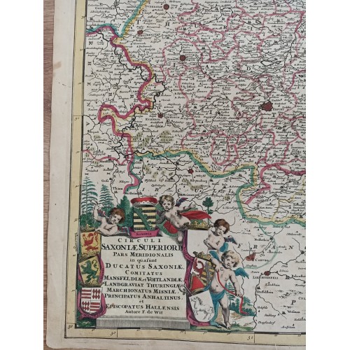
Circuli Saxoniж Superioris Pars Meridionalis in qua sunt Ducatus Saxoniж, Comitatus Mansfeldiж, et Voitlandiж, Landgraviat Thuringiж, Marchionatus Misniж, Principatus Anhaltinus, et Episcopatus Hallensis Autore F. de Wit.
Description: Striking and highly detailed interesting 1688 Frederik de Wit's copper engraved map of Saxony in eastern Germany, and part of western Czech Republic. Includes the cities of Erfurt, Mansfeld, Weimar, Eisenach, Heiligenstadt, Altenburg, Leipzig, Dresden, Meissen, Plauen and several others. The entire region is depicted in extraordinary detailed, offering both topographical and political information, with cities, towns, villages, rivers, lakes, roads, reliefs and forests.
The magnificent title cartouche is embellished with 7 coats of arms, cherubds and wwodly landscape. A monument-style cartouche includes two mileage scales.
Date: 1688 ( undated )
Dimension: Paper size approx.: cm 60,1 x 51,4
Condition: Very strong and dark impression on good paper. Paper with chains and wiremarks. Map old original colored. Wide margins. Corners partially missing. Small foxing and browning. Small tears. Small warmings affecting the map repaired on the verso. Map partially reinforced on the verso. Map folded. Conditions are as you can see in the images.
Mapmaker: Frederik de Wit (1629 - 1706) was a Dutch Golden Age cartographer active in the second half of the 17th and the early 18th centuries. De Wit was born of middle class Protestant stock in the western Netherlandish town of Gouda. He relocated to Amsterdam sometime before 1648, where he worked under Willem Blaeu. His first attributed engraved map, a plan of Haarlem for Antonius Sanderus' Flandria Illustrata, was issued around this time. He struck out on his own in 1654. The first chart that De Wit personally both drew and engraved was most likely his 1659 map of Denmark, REGNI DANIЖ Accuratissima delineatio Perfeckte Kaerte van ‘t CONJNCKRYCK DENEMARCKEN. His great wall map of the world and most famous work, Nova Totius Terrarum Orbis Tabula appeared one year later. Following the publication of his wall map De Wit quickly rose in prominence as a both cartographer and engraver. He married Maria van der Way in 1661 and through her became a citizen of Amsterdam in 1662. Around this time he also published his first major atlas, a composite production ranging in size from 17 to over 150 maps and charts. Other atlases and individual maps followed. In 1689 De Wit was granted at 15 year Privilege by the Dutch States General. The Privilege was a kind of early copyright that protected his exclusive rights to print and publish his maps. He was recognized with the honorific 'Good Citizen' in 1694. De Wit died in 1706 after which his wife Maria continued publishing his maps until about 1710. Though De Wit did have a son, Franciscus, he had no interest in the map trade, being a prosperous stockfish merchant. Instead, on her own retirement, Maria sold most De Wit maps and plates at a public auction. Most were acquired by Pieter Mortier and laid the groundwork for the 1721 rise of Covens and Mortier, the largest Dutch cartographic publishing house of the 18th century.
10726
- Product Code: 10726
- Availability: In Stock
-
$0.00
- Ex Tax: $0.00