
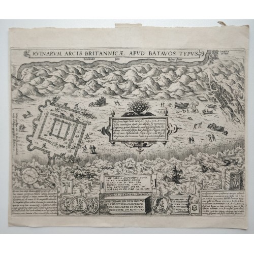
BRITTENBURG KATWIJK NETHERLANDS 1581 LODOVICO GUICCIARDINI UNUSUAL ANTIQUE VIEW
ANTIQUE COPPER ENGRAVED CITY VIEW OF BRITTENBURG 1581
Condition:
--not specified
Ended:Jul 09, 2022 , 7:05AM
Winning bid:
US $58.00
Cartographer/Publisher:
Lodovico Guicciardini
Country/Region:
Netherlands
Date Range:
1500-1599
Format:
Atlas Map
Original/Reproduction:
Antique Original
Printing Technique:
Copper Plate
Type:
City Map
Year:
1581
BRITTENBURG KATWIJK NETHERLANDS 1581 LODOVICO GUICCIARDINI UNUSUAL ANTIQUE VIEW
Description
Ruinarum Arcis Britannicж apud Batavos Typus.
Description: Striking and highly detailed fine unusual copper engraved plan depicting the remnants of Arx Britanica (also called Huis Britten, Brittenberg and Arx Britannica) Roman Castle at the mouth of the Rhine River.
Arx Britanica was fortress constructed by the Romans. The foundation of the fortress was one of the most prominent geological landmarks on the coast of Holland and could be seen at low tide at the mouth of the Middle Rhine. Legend explains that the castle was constructed at the time of the Roman Emperor Caligula, during his conquest of Britain, or by Drusus, with a later alter during the time of Claudius, who conducted an expedition to Britain. By the end of the 17th Century, "the sea had advanced sixteen hundred paces beyond it." Marsch, The Earth and Modfied by Man's Action.
Depictions of the Fortress are quite rare. Abraham Ortelius made a drawing of the building in 1567, which was copied in an engraving dated 1581. Guicciardini produced a map of Arx Britannica in 1612. Langenes also made a small map in 1649, as did Blaeu in the same year. Moll's map of the Netherlands includes a plan.
The plate originates from the 1613 edition of 'Discrittione di tutti i Paesi Bassi', by L. Guicciardini.
Date: 1581 ( undated )
Dimension: Paper size approx.: cm 32,9 x 27,6
Condition: Very strong and dark impression on good paper. Paper with chains. Plate uncolored. Wide top and lower margins. Small lateral margins. Corners partially missing. Paper with foxing and browning. Sheet folded. Conditions are as you can see in the images.
Mapmaker: Lodovico Guicciardini (19 August 1521 - 22 March 1589) was an Italian writer and merchant from Florence who lived primarily in Antwerp from 1542 or earlier. He was the nephew of historian and diplomat Francesco Guicciardini. His best-known work, the “Descrittione di Lodovico Guicciardini patritio fiorentino di tutti i Paesi Bassi altrimenti detti Germania inferior” (1567, Description of the Low Countries), was an influential account of the history and the arts of the Low Countries, accompanied by city maps by various leading engravers. Guicciardini died in Antwerp in 1589; he was buried there in the Cathedral of Our Lady.
10711
- Product Code: 10711
- Availability: In Stock
-
$0.00
- Ex Tax: $0.00