
List on eBAY
BOX 21-01-25
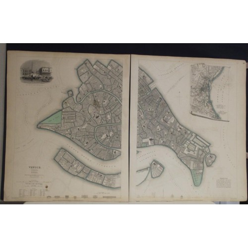
VENICE VENEZIA ITALY 1838 S.D.U.K. LARGE 2-SHEETS ANTIQUE STEEL ENGRAVED MAP
ANTIQUE STEEL ENGRAVED CITY MAP OF VENICE VENEZIA 1838
old times rare books and maps
(20087)
100% positiveSeller's other itemsSeller's other itemsContact seller
US $89.00
VENICE VENEZIA ITALY 1838 S.D.U.K. LARGE 2-SHEETS ANTIQUE STEEL ENGRAVED MAP
Description
Venice. Venezia. Venedig.
Description: Striking and highly detailed fine unusual 1838 steel engraved double-page SDUK town plan of Venice, with an inset view of the Piazza San Marco from the Grande Canal.
Includes profile views of the Ponte De La Rialto, Piazza Rialto, La Zecca, Prigoni, St. Marco, Palazzio, Piazza San Marco, Chiesa del Redentore, Campanile St. Marco, Chiesa di S. Giorgio Maggiore and Dogana (Customs House). The map is titled with the English, Italian, and German names for Venice; it was at the time a seat (with Milan) of the Lombardo-Venetian Kingdom in the Austrian Empire.
One of the best 19th-century English towns plans to appear in a commercial atlas. The inset map, pictured on an unfurled scroll, shows the Gulf of Venice. A vignette of St. Marks and vicinity is in the upper-left corner. The key shows major buildings at the bottom.
The Society for the Diffusion of Useful Knowledge (S.D.U.K.) Atlas was initially issued in parts over several years by Baldwin and Craddock to promote the society's mission of egalitarian self-education. The first S.D.U.K. began appearing in 1829 when the society contracted John Walker to produce the first proofs. The first S.D.U.K maps were produced serially by Baldwin and Craddock and issued in 2 map batches, priced at 2 shillings each. The series, originally anticipated to feature 50 maps, ultimately contained 200 and took over 14 years to produce. The initial production was completed in 1844 when the whole was issued in its first compiled atlas edition. Around 1842, following the 1837 bankruptcy of Baldwin and Craddock, publication of the atlas was taken over by the Society itself, who issued editions in 1838, 1839, 1840, 1841, and 1842. Overburdened by the work of publishing, they then outsourced the publication to Chapman and Hall in 1842. Chapman and Hall produced editions in 1842, 1843, and 1844. Dissatisfied with the quality of Chapman and Hall printing, the Society turned to another publisher, Charles Knight, who issued editions under the auspices of the Society in 1844, 1845, and 1846. In 1846 Knight officially acquired the plates in his own right and reissued in revised editions until 1852, when he sold them to George Cox. Cox in turn sold them to Edward Stanford who published them from 1856 well into the 1860s. The S.D.U.K. Atlas is known for the quantity and quality of its maps. The S.D.U.K. published many maps of areas largely ignored by other publishers. The many city plans incorporated into the atlas are particularly admired and are the highlight of the S.D.U.K.'s long map publishing history. As a whole the S.D.U.K. Atlas was groundbreaking in terms of quality, scope, and being offer at a cost effective price point.
Date: 1838 ( dated )
Dimension: Paper size approx.: cm 33,4 x 40,9 (left sheet) & cm 33,4 x 40,9 (right sheet)
Condition: Very strong and dark impression on good paper. Map old original colored. Map folded. Small foxing and browning. Map folded. Conditions are as you can see in the images.
Mapmakers: The "Society for the Diffusion of Useful Knowledge" (1826 - 1848) was a Whiggish organization founded in 1828 at the instigation of idealistic British lord Henry Peter Brougham. The admirable goal of the Society was to distribute useful information via a series of publications to the English working and middle classes. It promoted self-education and the egalitarian sharing of all knowledge. While closely tied to the London University and publishing houses on the order of Baldwin and Cradock, Chapman and Hall, and Charles Knight, the Society failed to achieve its many lofty goals in finally closed its doors in 1848. Most likely the failure of the Society resulted from its publications being too expensive for its intended lower to middle class markets and yet not large and fine enough to appeal to the aristocratic market. Nonetheless, it did manage to publish several extraordinary atlases of impressive detail and sophistication. Their most prominent atlas consisted of some 200 separately issued maps initially published by Baldwin and Cradock and sold by subscription from 1829 to 1844. Afterwards, the Society combined the maps into a single world atlas published under the Chapman and Hall imprint. In its day, this atlas was unprecedented in its quality, scope, and cost effectiveness. Today Society, or S.D.U.K. as it is commonly known, maps are among the most impressive examples of mid-19th century English mass market cartographic publishing available. The S.D.U.K. is especially known for its beautiful and accurately detailed city plans.
9926
- Product Code: 9926
- Availability: In Stock
-
$0.00
- Ex Tax: $0.00