
List on Ebay
List on Ebay
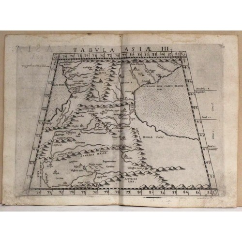
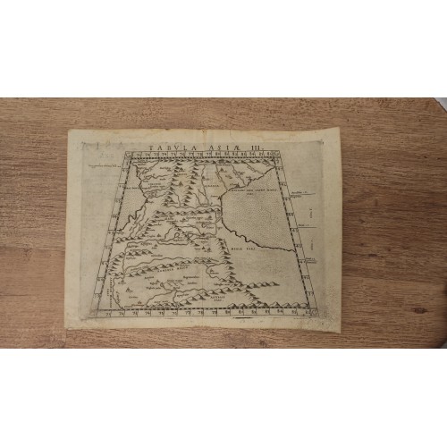
GEORGIA & ARMENIA 1574 RUSCELLI & PTOLEMY UNUSUAL ANTIQUE COPPER ENGRAVED MAP
ANTIQUE COPPER ENGRAVED MAP OF GEORGIA & ARMENIA 1574
Condition:
--not specified
Ended:
Nov 02, 2023 22:09:31 PDT
Winning bid:
Tabula Asiж III.
Description: Striking and highly detailed very interesting 1574 Girolamo Ruscelli’s copper engraved map of Georgia and Armenia. The map depicts the region between the The Black Sea and the Caspian Sea, extends into the territory of the Middle East and as far south as Mesopotamia. The map first appeared in the 1561 edition of Ruscelli's edition of Ptolemy's Geografia.
Colchis is in its place on the Black Sea coast, and a large area to the east of Armenia, is labeled Assyriae. Caucasian Albania is in its place to the northwest of the Caspian Sea, with the neighboring Kingdom of Iberia to the west. Centered on present-day Eastern Georgia, it was bordered by Colchis in the west, Caucasian Albania in the east and Armenia in the south. Its population, the Iberians, formed the nucleus of the Kartvelians (i.e. Georgians).
Close to the eastern end of the Caucasus range a defile opens up not far from the shore of the Caspian; this is the Darband pass, called the Gates of Albania and the Caspian Gates by the ancients. Ruscelli has labeled it ‘the Gates of Albania’ along with a vignette of an edifice no doubt intended to represent gates. Cappadocia, which is located in central Turkey is mistakenly shown on the southeastern coast of the Black Sea. The Caucasus Mountains are depicted pictorially and many river systems are denoted. Both seas are stippled. Italian text on the verso describes the areas depicted on the map.
Source: La Geografia di Claudio Tolomeo alessandrino giа tradotta di greco in italiano da M. Giero. Ruscelli & hora in questa nuova editione da M. Gio. Malombra ricorretta & purgata d'infiniti errori con un discorso di M. Gioseppo Moleto, in Venetia, appresso Giordano Ziletti, 1574.
Date: 1574 ( undated )
Dimension: Paper size approx.: cm 29,6 x 21,8
Condition: Very strong and dark impression on good paper. Paper with chains. Sheet uncolored. Wide margins. Small foxing and browning. Small waterstains. Map folded. Conditions are as you can see in the images.
Cartographers: Girolamo Ruscelli (1500-1566) was a cartographer, humanist, and scholar from Tuscany. Ruscelli was a prominent writer and editor in his time, writing about a wide variety of topics including the works of Giovanni Boccaccio and Francesco Petrarch, Italian language, Italian poetry, medicine, alchemy, and militia. One of his most notable works was a translation of Ptolemy’s Geographia which was published posthumously.
There is limited information available about Ruscelli’s life. He was born in the Tuscan city of Viterbo to a family of modest means. He was educated at the University of Padua and moved between Rome and Naples until 1548, when he moved to Naples to work in a publishing house as a writer and proofreader. He remained in the city until his death in 1566.
Claudius Ptolemy (90 A.D.-168 A.D.) was a celebrated astronomer, mathematician, and geographer who lived in Alexandria in the 2nd century AD. Although his thinking influenced contemporary Arab geographers, little was known of his work in the West until manuscripts from Constantinople reached Italy in about 1400. These manuscripts were written in Greek and contained the names of every city, island, mountain and river known to the many travellers interviewed by Ptolemy. In addition, the latitude and longitude of each of the resulting eight thousand locations were also recorded. They were translated into Latin by 1401 and appeared in print by 1475. The earliest Byzantine manuscript maps, drawn by analysing the Ptolemy figures, date from the twelfth century. A number of hand-drawn copies were made in Italy throughout the early fifteenth century to accompany Ptolemys text.
Ptolemy stressed the importance of accurate observations in order to calculate latitude and longitude, and laid down the principals of systematic cartography that remain to this day. Obviously there are many errors in Ptolemys maps, due to the limited extent of basic geographic information at that time and the lack of a method of determining accurate longitudes. Judged by modern standards, the basic shortcoming of the Ptolemy world map is the small area it portrays. The Mediterranean is fairly well depicted, but is greatly exaggerated in length (Longitudinally). The effect of this, combined with Ptolemys disregard for Eratosthenes extremely accurate estimate of the earths circumference (c. 200 B.C.) and the use of a Posidonius much smaller flawed estimate (c.50 B.C.) implied a much shorter distance across that part of the unknown earths surface not drawn on the map. Columbus and his contemporaries based their exploratory ventures on Ptolemys calculations and, like him, had no idea of the vast New World to the west, interposed between Europe and Asia.
Work on the first printed atlas from the text of Ptolemy was started in 1473 and finally published in 1478. A crude copy of this atlas was produced and published by some dissident workers in 1477 in order to be first. However, the plates for the 1478 were done prior to the pirated issue and thus the 1478 atlas holds the title of the first Atlas of the world. There are very few surviving examples of this atlas and individual maps.
Translator: Giovanni Malombra (circa 1520 – circa 1580), floruit 1574, also known as Zuan Malombra and Zuanne Malombra, Italian geographer and translator.
Птолемей. Карта Закавказья, 1574 год.
"Tabula Asiae III"
Очень подробная интересная гравированная карта - оттиск с медной платины - территория Закавказья Джироламо Русчелли (Girolamo Ruscelli) 1574 года.
Изображённая на карте территория Закавказье вместе с прилегающими землями- Армения, Грузия и Албания (современный Азербайджан). На западе омывается Чёрным морем, а на востоке- Каспийским. Долгое время в Античности находилось под влиянием Урарту. В VIII веке до н.э. здесь был возведён город- предок будущей столицы Армении Еревана, который назывался Эребуни. В I тысячелетии до н.э. в Закавказье властвовала Держава Ахеменидов. На её осколках впоследствии появились Великая Армения, Кавказская Албания и Колхида, куда аргонавты во главе с Ясоном отправились за золотым руном. Древнегреческий миф имел веские основания считать Закавказье богатыми землями, ведь там до сих пор археологи поражаются обилию драгоценных находок и шедевров ювелирного искусства. В 301 г. н.э. Армения стала первой страной в мире, принявшей христианство в качестве официальной государственной религии. Вскоре её примеру последовали Грузия и Алания.
Вашему вниманию представлено издание карты Закавказья, составленной Птолемеем и выпущенной на латыни в Венеции 1574 года. Входила в труд «География», где подробно рассматривался и суммировался предыдущий опыт древних греко-римских учёных в этой науке. Карты Птолемея содержались в первых уменьшенных версиях карт Европы, Азии и Африки атласа не менее известного немецкого географа XVI века Меркатора.
Автор Клавдий Птолемей (Claudius Ptolemaus; около 100 г. н.э. - 170 г. н. э.) великий античный греко-египетский учёный, прославившийся как математик, астроном, географ и астролог. Родился и жил в египетском городе Александрия и его окрестностях, которые подчинялись Римской Империи. Писал на распространённом диалекте греческого языка койне. Создал несколько фундаментальных научных трудов. Наибольшей популярностью среди них пользовались «Математический трактат», «Астрологический трактат» и «География», важнейшие для поздней византийской, исламской и европейской науки.
Антикварная гравюра на меди, в отличной сохранности, размер листа 29,6 х 21,8 см. Издательский фальц. Бумага верже с водными знаками в виде характерной "решетки".
Яркий памятник одной из интереснейших для мировой культуры территории, с солидным возрастом!
9746
- Product Code: 9746
- Availability: In Stock
-
$0.00
- Ex Tax: $0.00