
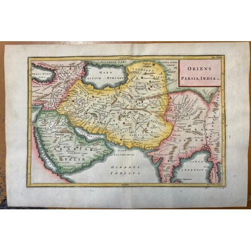
ARABIA IRAN IRAQ INDIA CENTRAL ASIA 1796 CELLARIUS & TOMS UNUSUAL ANTIQUE MAP
US $31.00
Description
Oriens Persia, India, &c..
Description: Striking and highly detailed fine unusual 1796 Christoph Cellarius's copper engraved historical map of the Central Asia, engraved by William Henry Toms. The map covers modern-days Arabian Peninsula, Iran, Iraq, Afghanistan, Armenia, western Turkey, Pakistan, northern India, Bangladesh, Bhutan, Nepal, Tibet and part of Myanmar (Burma). The map is filled with ancient place names, rivers, lakes, reliefs and islands. A decorative title cartouche adorns the map.
Date: 1796 ( undated )
Dimension: Paper size approx.: cm 37,4 x 25,5
Condition: Very strong and dark impression on good paper. Paper with chains. Map contemporary handcolored. Wide margins. Small foxing and browning. Conditions are as you can see in the images.
Mapmakers: Christoph Cellarius (1638 - 1707) or, more commonly, Christopher Keller was a German scholar, historian and textbook publisher working in the later part of the 17th century. Cellarius is known to have been born in Schmalkalden and to have held academic positions in both Weimar and Halle. C. Cellarius's most important contribution was his 1683 publication of A Universal History Divided into an Ancient, Medieval, and New Period. It was in this work that the concept of history as divisible into three distinct periods (Ancient History, Mediaeval History, and Modern History) was introduced. Likely Cellarius never understood the impact that his structured system of historical nomenclature would have on the way future historians would interpret the past. Christopher Cellarius should not be confused with the more widely known cosmographer Andreas Cellarius.
William Henry Toms (c. 1700–1765) was an English engraver. He worked on portraits, book-plates, landscapes and prints of buildings. Among his works were the plates for Robert West's "Perspective Views of All the Ancient Churches in London" (1736–1739). In 1741, he worked with Thomas Badeslade on "Chorographia Britanniae or a New Set of Maps of all the Counties in England and Wales". The maps were republished on 29 September 1742, with additional place names. Among Toms's apprentices was the engraver and publisher John Boydell. W. H. Toms lived in Masham Street, London, and was the father of the painter Peter Toms. Toms died in 1765.
Антикварная карта Центральной Азии 1796 года
Оригинальное название карты: "Oriens Persia, India, &c.."
Яркая и очень подробная, очень интересная и необычная карта Центральной Азии картографа Christoph Cellariusб выгравированная William Henry Toms
На карте изображены современные территории Аравийского полуострова, Ирана, Ирака, Армении, западной Турции, Пакистана, Северной Индии, бутана , Непала, Тибета и часть Бирмы.
На карте отмечены города, поселки, реки, озера, рельефы, заливы и острова.
Размер листа cm 37,4 x 25,5
Дата: 1796 (недатированная)
Обратная сторона чистая.
9739
- Product Code: 9739
- Availability: In Stock
-
$0.00
- Ex Tax: $0.00