
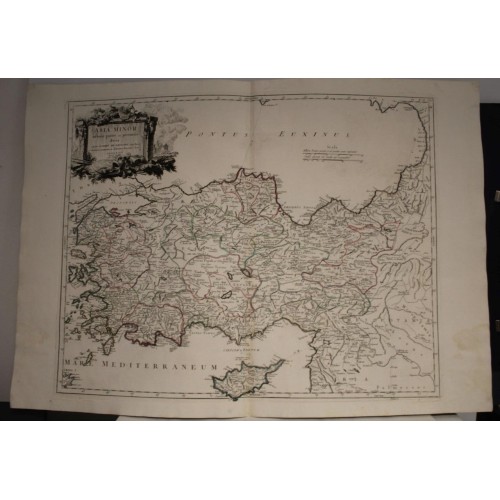
TURKEY & CYPRUS 1779 VAUGONDY & SANTINI ANTIQUE ORIGINAL COPPER ENGRAVED MAP
ANTIQUE ORIGINAL COPPER ENGRAVED MAP OF TURKEY & CYPRUS
Condition:
--not specified
Ended:Jun 06, 2022 , 7:11AM
Winning bid:
US $43.50
TURKEY & CYPRUS 1779 VAUGONDY & SANTINI ANTIQUE ORIGINAL COPPER ENGRAVED MAP
Description
Asia Minor in sua partes seu provincias divisa. Auctore Robert de VaugondyGeog Regis, et Academiж Scientiarum ac Litterarum Nanceianж Socio Venetiis Apud P. Santini Chez Mr. Rem.
Description: Striking and highly detailed interesting 1778 Paolo Santini's edition of the 1756 Robert de Vaugoundy's copper engraved map of Asia Minor or Turkey. It covers from the Aegean Sea to Mesopotamia and from the Black Sea to Cyprus. The map is filled with excellent topographic details on place names, rivers, lakes, reliefs and islands.
The map notes the ancient Kingdoms of Asia Minor, many of which were Greek colonies or heavily influences by Ancient Greek culture. These include Mysia, Hellespontus, Lycia, Pisidia, Cilicia, Phrygia, Bithynia, Cappadocia, Armenia Minor, Pontus and others. This region saw the development of currency, the conquest of Troy, as well as the construction of three of the Ancient World's Seven Wonders. An elegant large cartouche includes the title.
Date: 1779 ( undated )
Dimension: Paper size approx.: cm 75,7 x 53,1
Condition: Very strong and dark impression on good paper. Paper with chains and wiremarks. Map old original colored. Wide margins. Corners partially missing. Small foxing and browning. Map folded. Conditions are as you can see in the images.
Mapmakers: Gilles (1688 - 1766) and Didier (c. 1723 - 1786) Robert de Vaugondy were map publishers, engravers, and cartographers active in Paris during the mid-18th century. The father and son team were the inheritors to the important Sanson cartographic firm whose stock supplied much of their initial material. Graduating from Sanson's map's Gilles, and more particularly Didier, began to produce their own substantial corpus of work. Vaugondys were well respected for the detail and accuracy of their maps in which they made excellent use of the considerable resources available in 18th century Paris to produce the most accurate and fantasy-free maps possible. The Vaugondys compiled each map based upon their own superior geographic knowledge, scholarly research, the journals of contemporary explorers and missionaries, and direct astronomical observation - moreover, unlike many cartographers of this period, they commonly took pains to reference their source material. Nevertheless, even in 18th century Paris geographical knowledge was severely limited - especially regarding those unexplored portions of the world, including the poles, the Pacific northwest of America, and the interior of Africa and South America. In these areas the Vaugondys, like their rivals De L'Isle and Buache, must be considered speculative geographers. Speculative geography was a genre of mapmaking that evolved in Europe, particularly Paris, in the middle to late 18th century. Cartographers in this genre would fill in unknown areas on their maps with speculations based upon their vast knowledge of cartography, personal geographical theories, and often dubious primary source material gathered by explorers and navigators. This approach, which attempted to use the known to validate the unknown, naturally engendered many rivalries. Vaugondy's feuds with other cartographers, most specifically Phillipe Buache, resulted in numerous conflicting papers being presented before the Academie des Sciences, of which both were members. The era of speculatively cartography effectively ended with the late 18th century explorations of Captain Cook, Jean Francois de Galaup de La Perouse, and George Vancouver. After Didier died, his maps were acquired by Jean-Baptiste Fortin who in 1787 sold them to Charles-Franзois Delamarche (1740 - 1817). While Delamarche prospered from the Vaugondy maps, he also defrauded Vaugondy's window Marie Louise Rosalie Dangy of her inheritance and may even have killed her.
Paolo Santini (1729-1793) was an Venetian engraver known especially for his religious prints and fine cartographic engravings. He published in Venice and may have a been a member of the clergy. In his maps, he largely adopted and adapted the work of his French counterparts, especially the brothers de Vaugondy.
Remondini (fl. c. 1657 - 1861) were a family of printers who worked originally based in Bassano del Grappa, near Venice. Giovanni Antonio Remondini (1634-1711), the family patriarch, was born in Padua in 1634. In 1657, he took a home the main square of Bassano where he opened a shop drapes, wool, silk and iron tools. He also sold woodcuts of saints which proved popular with local farmers who believed they bought spiritual protection. When Giovanni died in 1711 his printing business fell into the hands of his son, Joseph Remondini. In 1750 Joseph expended the family business into Venice proper. Having several paper factories established by Giovanni Antonio, the Remondini were in a position to undercut competitors in Venice. The Remondini employed a number of talented engravers, including Paolo Santini, an Abbot who specialized in sacred images as well as cartography. Their corpus includes several beautifully produced atlases, though, cartographically speaking, little in the way of original work. The family fell into decline following the Napoleonic invasions, finally closing their doors in 1861. Most of the Remondini family's work is today preserved in the Museum of Bassano del Grappa and the Piccolo Remondini Museum of Vicenza.
All of the maps we sell are ORIGINALS. We guarantee all of our maps to be authentic. We do our best to describe the condition of our maps as accurately as possible. Due to the age and type of paper, some imperfections are to be expected. Please examine the images provided carefully, and if you have any questions please ask and we will be happy to help.
A Certification of Authenticity ( COA ) can be issued on request
I will send you all your item by Registered and Insured Airmal or by TNT/DHL with covering Insurance
If you buy more than one item you have to pay just one only shipping cost
Any map purchased from us may be returend for any reason for a full refund.
Shipping: Customs may be charged on international shipments. All customs charges are the responsiblity of the buyer and are not included in the selling price.
10368
- Product Code: 10368
- Availability: In Stock
-
$0.00
- Ex Tax: $0.00