
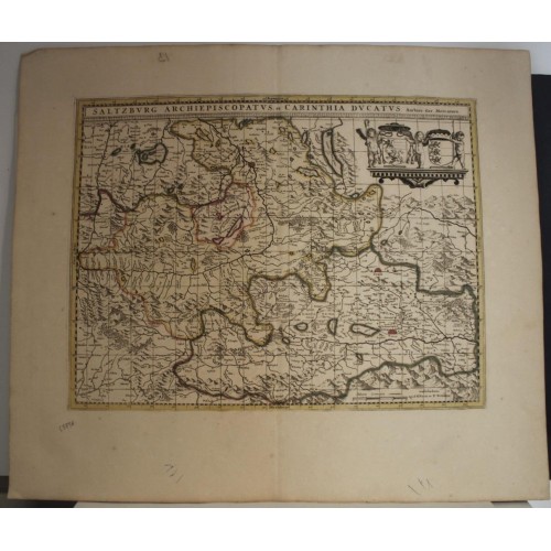
SALZBURG & CARINTHIA AUSTRIA 1702ca VALK & SCHENK ANTIQUE COPPER ENGRAVED MAP See original listing
SALZBURG & CARINTHIA AUSTRIA 1702ca VALK & SCHENK ANTIQUE COPPER ENGRAVED MAP
Item Sold
Condition:--
Ended:Jun 12, 2022 , 7:09AM
Winning bid:US $38.55
SALZBURG & CARINTHIA AUSTRIA 1702ca VALK & SCHENK ANTIQUE COPPER ENGRAVED MAP
Description
Saltzburg Archiepiscopatus, et Carinthia Ducatus. Auctore Ger. Mercatore.
Description: Striking and highly detailed very interesting large-format 1702 approx. Valk & Schenk's copper engraved map of the Austrian Salzburg region and Duchy of Carinthia. The map is filled with excellent topographic details on cities, towns, rivers, lakes, reliefs and regional divisions.
The cartography follows a map by Gerard Mercator, as declared in the title. Three cherubs hold two coats of arms in the upper right corner. A frame-style cartoucrhe at the top including the title amd a mileage scale complete the map.
The Duchy of Carinthia (German: Herzogtum Kдrnten; Slovene: Vojvodina Koroљka) was a duchy located in southern Austria and parts of northern Slovenia. It was separated from the Duchy of Bavaria in 976, and was the first newly created Imperial State after the original German stem duchies. Carinthia remained a State of the Holy Roman Empire until its dissolution in 1806, though from 1335 it was ruled within the Austrian dominions of the Habsburg dynasty. A constituent part of the Habsburg monarchy and of the Austrian Empire, it remained a Cisleithanian crown land of Austria-Hungary until 1918. By the Carinthian Plebiscite in October 1920, the main area of the duchy formed the Austrian state of Carinthia.
The Prince-Archbishopric of Salzburg (German: Fьrsterzbistum Salzburg) was an ecclesiastical principality and state of the Holy Roman Empire. It comprised the secular territory ruled by the archbishops of Salzburg, as distinguished from the much larger Catholic diocese founded in 739 by Saint Boniface in the German stem duchy of Bavaria. The capital of the archbishopric was Salzburg, the former Roman city of Iuvavum. From the late 13th century onwards, the archbishops gradually reached the status of Imperial immediacy and independence from the Bavarian dukes. Salzburg remained an ecclesiastical principality until its secularisation to the short-lived Electorate of Salzburg (later Duchy of Salzburg) in 1803. Members of the Bavarian Circle from 1500, the prince-archbishops bore the title of Primas Germaniae, though they never obtained electoral dignity; actually of the six German prince-archbishoprics (with Mainz, Cologne and Trier), Magdeburg, Bremen and Salzburg got nothing from the Golden Bull of 1356. The last prince-archbishop exercising secular authority was Count Hieronymus von Colloredo, an early patron of Salzburg native Wolfgang Amadeus Mozart.
Date: 1702 approx. ( undated )
Dimension: Paper size approx.: cm 62,6 x 54,2
Condition: Very strong and dark impression on good. Paper with chains and wiremarks. Map old original colored. Wide margins. Corners partially missing. Small foxing and browning. Small tears. Map folded. Conditions are as you can see in the images.
Cartographers: The Valk Family
Gerard Valk (Valck) (1652-1726) was a publisher, engraver, art seller, and globemaker of Amsterdam. He was trained under Abraham Bloteling, later becoming his assistant. The two moved to London where Valk worked with various map and print-sellers. He married Abraham’s sister, Maria Bloteling, in London around 1673; in that city, his son and successor, Leonard, was born in 1675. Not long after, Bloteling and Valk returned to Amsterdam where Gerard Valk was registered as a burgher on December 8, 1679. Around 1680 he began working with the German engraver Petrus Schenk as engravers, publishers, map and print-sellers. They acquired the plates for the Janssonius Novus Atlas and Sanson’s maps. Although they never shared premises, they worked closely together in the publications of editions of these works. Valk and his son Leonard are best known for their globemaking. In addition to globes newly compiled from the latest geographical and astronomical information, the Valk’s published theoretical works on astronomy and globes. In 1710, the family tie between the two partners, Valk and Schenk, became even closer when Gerard’s son Leonard Valk (1675-1746) married Maria Schenk (1688-1770), Petrus’ daughter. After the death of Gerard in 1726, the business continued in the hands of his son Leonard and Gerard’s widow Maria until she died in 1729, and then by Leonard until his death in 1746.
The Schenk Family
Petrus Schenk (1660-1718), the founder of one of the best-known publishing firms of Amsterdam in the 18th century, was born in Elberfeld, Germany, in 1660. He went to Amsterdam where he became a pupil of the engraver Gerard Valck. On 19 Nov. 1686, a privilegio was granted to Petrus Schenk and Gerard Valk for the manufacturing and selling of their prints. Schenk’s contribution to cartography dates from c. 1695. In 1706 he moved to the Vijgendam in Amsterdam, ‘in Sanson’s Atlas’. After he died in 1718 his son, Leonardus Schenk, continued the art and print shop. The second son, Petrus II, settled in another famous house: ‘in Visscher’s Atlas’ where he continued the association with Gerard and Leonarus Valck. The Schenk family produced general geographical atlases and special atlases. Apart from seventy original maps, several hundred are known with the name of Schenk, which were printed from plates obtained from Janssonius and Visscher. Schenk and Valck acquired all the plates of the Janssonius Heir’s Novus Atlas, Celestial atlas included. Many of Janssonius’ plates were reworked and amended. The republishing of the maps from Janssonius’ Novus Atlas since c. 1680 was followed by the engraving of new maps, copied from Sanson’s better and more modern maps. Petrus Schenk published these maps in his Atlas Contractus sive mapparum geographicarum Sansoniarum auctarum et correctum Nova Congeries, also called Atlas Minor. After 1719, Petrus Schenk II continued the Atlas Contractus. Petrus Schenk, the elder, enjoyed great fame as a print-seller and artist among art-and print-dealers in the whole of Europe. The great activity in map publishing, displayed by Petrus Schenk, the elder, was continued by his son and grandson. But the number of original atlas-maps is small. Like his father, who bought the copperplates of Janssonius’ atlas, Petrus Schenk II bought many of the plates formerly owned by Nicolaas Visscher. Apart from the globes, maps and atlases, Petrus Schenk II published many books. He was older men of the booksellers guild in 1733.
Gerard Mercator (1512 – 1594)
Gerard Mercator was born as Gerard de Cremere in Rupelmonde (near Antwerp) on 5 March 1512.
Young Gerard learned what Latin he could in Rupelmonde, and when he was about fifteen, his uncle sent him to ’s Hertogenbosch to study at a school run by the Brothers of the Common Life. One of Mercator’s teachers was the celebrated humanist Macropedius. After three and a half years with the brothers, Gerard went to Louvain, where he enrolled in the university in 1530 as one of the poor students at Castle College.
By this time, he had Latinized his name to Mercator. He studied philosophy and took his master’s degree in 1532. The problems of the creation of the Universe and the Earth interested him in particular; this is reflected by his works, written in later years.
After spending a few years in Antwerp, he returned to Louvain c. 1535, where he took courses in mathematics under the guidance of Gemma Frisius. Soon he was recognised as an expert on the construction of mathematical instruments, as a land-surveyor and, after 1537, as a cartographer. He drew his income from these activities after his marriage on 3 August 1536. He also qualified himself as a copper-engraver; he was the first in history to introduce the italic handwriting to this trade. The first maps, drawn and engraved by Gerard Mercator are: Palestine, 1537; the world in double heart-shaped projection, 1538; and Flanders, 1540.
In 1544, Mercator came into great danger: he was arrested on the accusation of heresy and put into jail. Thanks to intervention of the University of Louvain, he was released after four months. In 1552, he moved with his family into the city of Duisburg (Germany). In 1560, Mercator became cosmographer in service of the Duke of Jьlich-Cleve-Berge and in 1563 he became lecturer at the Grammar School of the new University in Duisburg. During this period, he made wall-maps of Europe, 1554; of Loraine, 1564; the British Isles, 1564; and the famous map of the world with increasing latitudes, 1569. About this time, Mercator was also working on the project for a complete description of the Creation, the Heavens, Earth, and Sea and a world history. Out of this resulted his Atlas, sive cosmographicae meditationes de fabrica mundi et fabricati figura. He worked also on an edition of Ptolemy’s Geographia which appeared in 1578. The first part of his book with modern maps (France, Germany and the Netherlands) appeared in 1585.
Shortly after the publication of the second part of his map-book (not yet called Atlas) with the maps of Italy (1589), he had a stroke which brought an end to his extremely great productivity. The great man passed away on 2 December 1594, leaving the responsibility of finishing the map-book to his son Rumold. The final part of it appeared in 1595. Its title is Pars Altera and it constitutes an essential part of what was then called Mercator’s Atlas.
The map of Europe and the world map in the Atlas are by Rumold Mercator. After Rumold’s death in 1599, the Atlas was reissued once more in 1602.
The plates of the maps, both of the Ptolemy edition and the Atlas, were sold in 1604 to Jodocus Hondius of Amsterdam. The following year Hondius managed to bring out Ptolemy’s Geographia. In the following year, 1606, the first Amsterdam edition of the Mercator Atlas appeared. From then to 1638, the Atlas saw many enlarged editions in various languages.
All of the maps we sell are ORIGINALS. We guarantee all of our maps to be authentic. We do our best to describe the condition of our maps as accurately as possible. Due to the age and type of paper, some imperfections are to be expected. Please examine the images provided carefully, and if you have any questions please ask and we will be happy to help.
A Certification of Authenticity ( COA ) can be issued on request
I will send you all your item by Registered and Insured Airmal or by TNT/DHL with covering Insurance
If you buy more than one item you have to pay just one only shipping cost
Any map purchased from us may be returend for any reason for a full refund.
Shipping: Customs may be charged on international shipments. All customs charges are the responsiblity of the buyer and are not included in the selling price.
10364
- Product Code: 10364
- Availability: In Stock
-
$0.00
- Ex Tax: $0.00