
LIST ON EBAY
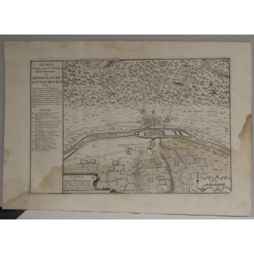
PARIS FRENCH LUTETIA FRANCE 1724 DE FER & DANET ANTIQUE COPPER ENGRAVED CITY MAP
ANTIQUE ORIGINAL COPPER ENGRAVED CITY MAP OF PARIS 1724
Condition:
--not specified
Ended:
Dec 11, 2023 21:17:34 PST
Winning bid:
US $52.00
PARIS FRENCH LUTETIA FRANCE 1724 DE FER & DANET ANTIQUE COPPER ENGRAVED CITY MAP
Description
Lutece Conquise par les Franзois sur les Romains ou Second Plan de la Ville de Paris Tirй du Misopagene de l'Empereur Iulien, d'Ammian Marcelin, de Gregoire de Tours ..... A Paris Chez le Sr. Danet, gendre de l'auteur sur le Pont Nфtre Dame a la Sphere Royale avec Privilege du Roy 1720.
Description: Striking and highly detailed interesting 1724 Guillaume Danet's edition of the Nicolas de Fer's copper engraved map of the ancient Lutetia, modern-days Paris, France, after the reconquest by the Franch over the Romains. The plan shows the city with his buildings, temples, town walls and surrounding landscape.
Lutetia, (French: Lutиce) also known as Lutecia and Lutetia Parisiorum (lit. 'Lutetia of the Parisii'), was a Gallo–Roman town and the predecessor of modern-day Paris. Traces of an earlier Neolithic settlement (c. 4500 BC) have been found nearby, and a larger settlement was established around the middle of the third century BC by the Parisii, a Gallic tribe. The site was an important crossing point of the Seine, the intersection of land and water trade routes.
In the first century BC, the settlement was conquered by Romans and a city began to be built. Remains of the Roman forum, amphitheatre, aqueduct and baths can still be seen. In the fifth century it became the capital of the Merovingian dynasty of French kings, and thereafter was known as Paris.
Many artifacts from Lutetia have been recovered and are on display at the Musйe Carnavalet.
A simple title att he top left quadrant, a decorative mileage scale cartouche, a letterd key along left lateral side and a monument-style publisher's note cartouche complete the map.
Date: 1724 ( dated )
Dimension: Paper size approx.: cm 40,2 x 27,6
Condition: Very strong and dark impression on good paper. Paper with chains and wiremarks. Map uncolored. Wide margins. Small foxing and browning. Paper with waterstains. Conditions are as you can see in the images.
Mapmaker: Nicholas de Fer (1646 - October 25, 1720) was a French cartographer and publisher, the son of cartographer Antoine de Fer. He apprenticed with the Paris engraver Louis Spirinx, producing his first map, of the Canal du Midi, at 23. When his father died in June of 1673 he took over the family engraving business and established himself on Quai de L'Horloge, Paris, as an engraver, cartographer, and map publisher. De Fer was a prolific cartographer with over 600 maps and atlases to his credit. De Fer's work, though replete with geographical errors, earned a large following because of its considerable decorative appeal. In the late 17th century, De Fer's fame culminated in his appointment as Geographe de le Dauphin, a position that offered him unprecedented access to the most up to date cartographic information. This was a partner position to another simultaneously held by the more scientific geographer Guillaume De L'Isle, Premier Geograph de Roi. Despite very different cartographic approaches, De L'Isle and De Fer seem to have stepped carefully around one another and were rarely publicly at odds. Upon his death of old age in 1720, Nicolas was succeeded by two of his sons-in-law, who also happened to be brothers, Guillaume Danet (who had married his daughter Marguerite-Geneviиve De Fer), and Jacques-Franзois Bйnard (Besnard) Danet (husband of Marie-Anne De Fer), and their heirs, who continued to publish under the De Fer imprint until about 1760. It is of note that part of the De Fer legacy also passed to the engraver Remi Rircher, who married De Fer's third daughter, but Richer had little interest in the business and sold his share to the Danet brothers in 1721.
Guillaume Danet (1670 – 1732) was a Paris based French bookseller and map publisher active in the late 17th and early 18th century. Danet married Marguerite-Geneviиve De Fer becoming the son-in-law of the cartographer and map publisher Nicolas De Fer (1626 – 1720). Along with his brothers and brothers-in-law, Jacques-Franзois Bйnard (Besnard) Danet (husband of Marie-Anne De Fer and engraver to the King of Spain) and Remi Richer (an engraver who sold portion of the De Fer business to his brothers in 1721), Guillaume Danet inherited a portion Nicolas De Fer's publishing business in 1720. Both Danet and Bйnard used the De Fer name and signage concurrently. Danet maintained a book and map shop on the Pont Notre-Dame. After Danet's own death in 1732, the business was continued by his widow, Marguerite-Geneviиve, until about 1746. Marguerite-Geneviиve died in 1746 after which many of the De Fer / Danet plates were acquired by Louis Charles Desnos.
5300
- Product Code: 5300
- Availability: In Stock
-
$0.00
- Ex Tax: $0.00