
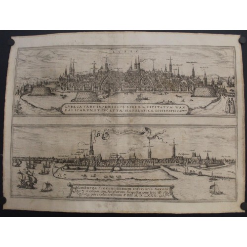
LЬBECK & HAMBURG GERMANY 1572 BRAUN & HOGENBERG ANTIQUE COPPER ENGRAVED VIEWS
ANTIQUE COPPER ENGRAVED CITY VIEWS OF LЬBECK & HAMBURG
Condition:
--not specified
Ended:
Sep 07, 2023 22:17:34 PDT
Winning bid:
US $103.50
LЬBECK & HAMBURG GERMANY 1572 BRAUN & HOGENBERG ANTIQUE COPPER ENGRAVED VIEWS
Description
Lubeca Urbs Imperialis Libera, Civitatum Wandalicarum, et Inclytж Hanseaticж Societatis Caput. // Hamburga, Florentissimum Inferioris Saxoniae Emporium, Anglorum frequetatione hoc tepore celeberrimum A° Dni: M.D.LXXII.
Description: Striking and highly detailed fine unusual copper engraved map featuring, on one sheet, the aerial plans of the German Cities of Lьbeck & Hamburg. Each view shows the city with his buildings, churches, town walls and surrounding landscape. A banner-style title cartouches, two strapwork title cartouches, several sailing ships and a couple in their typical dresses adorn the sheet. French text on the verso.
LЬBECK
TRANSLATION OF CARTOUCHE TEXT: The Free Imperial City of Lьbeck, capital of the Vandals and the world-famous Hanseatic League.
COMMENTARY BY BRAUN: "Lьbeck is well fortified in our day with massive bulwarks, which lie on strong stakes in the water. It possesses two long streets, which are crossed by the others and which lead down to the Rivers Trave and Wakenitz; the streets are spotless because all the dirt runs off into the rivers. Lьbeck also has handsome churches with tall towers roofed in copper and lead, and gold spires. The water is conveyed from the river to a high tower by an ingeniously designed mill. From there, it runs via the ground and into the townhouses so that an unknowing observer might think it came from a spring."
The view shows the "City of Seven Spires" on the Baltic Sea seen from the west across the inland harbour, with the city gates - the Holstentor, left, Molentor and Burgtor, right - and the spires of its seven Gothic red-brick churches, all of which evolved out of existing Romanesque churches. Lьbeck's Gothic cathedral (De Dom) is rising magnificently on the left. Further right lies the church of St Giles (S. Tillien), the imperial church of St Peter (S. Petri) and the town Hall. St Mary's (Unse Lefrowen Karck) served the merchants, city council and people of Lьbeck and is considered the mother church of red-brick Gothic architecture in northern Germany: it would provide the model for some 70 churches in the Baltic region. On the far right, finally, is the church of St. James (S. Iakob), dedicated to the patron saint of sailors and fishermen.
HAMBURG
CARTOUCHE: Hamburg, a flourishing centre of trade in Lower Saxony in our times mainly well known for its many English visitors. In the year of our Lord 1572.
COMMENTARY BY BRAUN: "Hamburg is ten miles from Lьbeck, is abundantly surrounded by water and therefore is best placed to conduct international trade; for this reason, one sees many English here, who no longer travel to Antwerp, but transact their business here. As far as the city walls, the moats, the barriers and the wealth of the inhabitants is concerned, I have seen nothing more beautiful or better fortified than Hamburg. There are very splendid buildings here that are equipped with water pipes. For want of wine, the Hamburgers brew beer, which is drunk with great pleasure not only in the city but in all the towns of Lower Saxony; it is quite astonishing to see how the people get drunk on beer: it is even the case that the one who can drink the most receives the most praise and admiration. [...]"
This view, showing the city from a low vantage point, reveals its rural character. Left stands the 153-m-high tower of the church of St Nicholas, which was completed in 1517 in the north-German brick-Gothic style. To the right is the spire of St Peter's. The modern city landmark, the Hamburger Michel, was finished in 1786 as the tower of the Baroque church of St Michael. After Emperor Frederick I Barbarossa granted the city port rights in 1189 and tax exemption on trading with the entire Lower Elbe region, Hamburg grew into a vibrant commercial hub. Boasting up to 600 breweries, the city was the purveyor of beer to the Hanseatic League.
Braun G. & Hogenberg F. and the Civitates Orbis Terrarum.
The Civitates Orbis Terrarum, or the "Braun & Hogenberg", is a six-volume town atlas and the greatest book of town views and plans ever published: 363 engravings, sometimes beautifully coloured. It was one of the best-selling works in the last quarter of the 16th century. Georg Braun wrote the text accompanying the plans and views on the verso. A large number of the plates were engraved after the original drawings of Joris Hoefnagel (1542-1600), who was a professional artist. The first volume was published in Latin in 1572, and the sixth in 1617. Frans Hogenberg created the tables for volumes I through IV, and Simon van den Neuwel created those for volumes V and VI. Other contributors were cartographers Daniel Freese and Heinrich Rantzau. Works by Jacob van Deventer, Sebastian Mьnster, and Johannes Stumpf were also used. Translations appeared in German and French.
Following the original publication of Volume 1 of the Civitates in 1572, seven further editions of 1575, 1577, 1582, 1588, 1593, 1599 and 1612 can be identified. Vol.2, first issued in 1575, was followed by further editions in 1597 and in 1612. The next volumes appeared in 1581, 1588, 1593, 1599 and 1606. The German translation of the first volume appeared from 1574 on, and the French edition from 1575 on.
Several printers were involved: Theodor Graminaeus, Heinrich von Aich, Gottfried von Kempen, Johannis Sinniger, Bertram Buchholtz and Peter von Brachel, who all worked in Cologne.
Date: 1572 ( undated )
Dimension: Paper size approx.: cm 50,3 x 37,6
Condition: Very strong and dark impression. Sheet sticked on canvas on the verso. Plate uncolored. Wide margins. Coners partially missing. Small foxing. Sheet heavy washed and restored. Conditions are as you can see in the images.
Mapmakers: Georg Braun (also Brunus, Bruin; 1541 – 10 March 1622) was a topo-geographer. From 1572 to 1617 he edited the Civitates orbis terrarum, which contains 546 prospects, bird's-eye views and maps of cities from all around the world. He was the principal editor of the work, he acquired the tables, hired the artists, and wrote the texts. He died as an octogenarian in 1622, as the only survivor of the original team to witness the publication of volume VI in 1617.
Braun was born and died in Cologne. His principal profession was as a Catholic cleric, however, he spent thirty-seven years as canon and dean at the church, St. Maria ad Gradus, in Cologne. His six-volume work was inspired by Sebastian Mьnster's Cosmographia. In form and layout it resembles the 1570 Theatrum orbis terrarum by Abraham Ortelius, as Ortelius was interested in a complementary companion for the Theatrum.
The Braun publication set new standards in cartography for over 100 years. Frans Hogenberg (1535–1590, from Mechelen) created the tables for volumes I through IV, and Simon van den Neuwel created those for volumes V and VI. Other contributors were Joris Hoefnagel, Jacob Hoefnagel, cartographer Daniel Freese, and Heinrich Rantzau. Works by Jacob van Deventer, Sebastian Mьnster, and Johannes Stumpf were also used. Primarily European cities are depicted in the publication; however, Casablanca and Mexico City/Cuzco on one sheet[4] are also included in volume I.
Frans Hogenberg (1535–1590) was a Flemish and German painter, engraver, and mapmaker.
Hogenberg was born in Mechelen as the son of Nicolaas Hogenberg. In 1568 he was banned from Antwerp by the Duke of Alva and travelled to London, where he stayed a few years before emigrating to Cologne. He is known for portraits and topographical views as well as historical allegories. He also produced scenes of contemporary historical events.
Hogenberg died in Cologne.
4897
- Product Code: 4897
- Availability: In Stock
-
$0.00
- Ex Tax: $0.00