
LIST ON EBAY
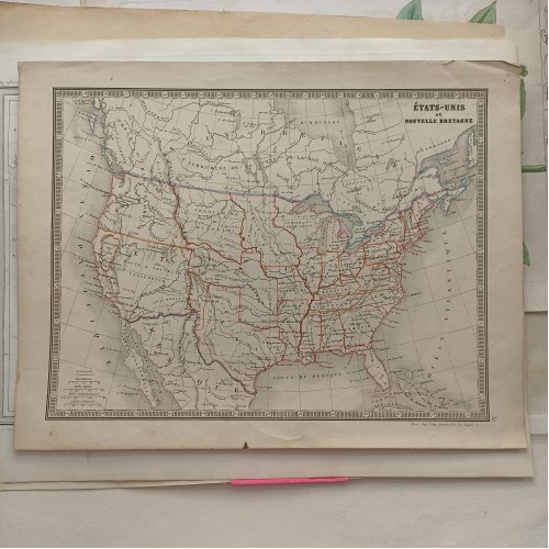
United States 1849 Vuillemin & Monin Unusual Antique Original Lithographic Map
ANTIQUE ORIGINAL COLORED LITHOGRAPHIC MAP UNITED STATES
old times rare books and maps
More from old times rare books and maps (19073)
100% positive
Contact seller
Condition:
--not specified
“DEPICTS THE GOLD REGION IN CALIFORNIA, UNITED STATES”
Ended:
Apr 16, 2023 22:31:36 PDT
Winning bid:
US $87.00
UNITED STATES 1849 VUILLEMIN & MONIN UNUSUAL ANTIQUE ORIGINAL LITHOGRAPHIC MAP
Description
Afrique Mйridionale Dressйe par C.V. Monin.
Description: Striking and highly detailed fine unusual 1849 Alexandre Vuillemin & Charles V. Monin's original colored lithographic map of the United States, most notable for its unusual location of Region De L'Or (Gold Region) in California, a most unusual reference on a French map. 54-40 or fight Oregon Territorial Border, Large Missouri Territory and Indian Territory are shown. The Southwest is still called Upper California, and Appacharia appears prominently. New Mexico is still in its Mexican provincial configuraion and Texas is also oddly configured. A massive District of Iowa is shown, alont with the Northwest Territory, suggesing that while the French had it right in the west, they had not yet updated the map to show Wisconsin or Minnesota Territory. An scarce and interesting map. Many Indian Tribes and Western Forts located.
Date: 1849 ( undated )
Dimension: Paper size approx.: cm 32,9 x 25,2
Condition: Very strong and dark impression on good paper. Map old original colored. Good margins. Small foxing and browning. Conditions are as you can see in the images.
Mapmaker: Charles V. Monin (1830 - 1880) was a French map publisher working the early to mid 19th century. A progressive printer, Monin was one of the first cartographic printers in Europe to take advantage of the newly discovered lithographic engraving process. His workshops in Paris and Caen, France, produced three important atlases as well as numerous independent issue maps. Monin was a member of La Sociйte de Gйographie in Paris. He is known to have worked with other French map publishers including Vuillemin and Fremin.
Alexandre Vuillemin (1812-1880) was a prominent 19th century French cartographer and editor based in Paris. He produced a number of atlases, and his maps are noted for the frequent use of extensive margin illustrations - vignettes, famous people, and views of cities. His atlases were popular, and many went through multiple editions. Despite a prolific cartographic career, not a lot is known of Vuillemin's life. He studied under the French cartographer Auguste Dufour (1798 - 1865), and his atlases and maps are held by and available through many collections including the British Museum and the University of Alabama Historical Maps of Europe Archive. Vuillemin's most important works include his detailed, highly decorative large format Atlas Illustrй de Gйographie Commerciale et Industrielle as well as his many French Atlases.
United States 1849 Vuillemin & Monin Unusual Antique Original Lithographic Map
- Product Code: 3542
- Availability: In Stock
-
$0.00
- Ex Tax: $0.00