
LIST ON EBAY
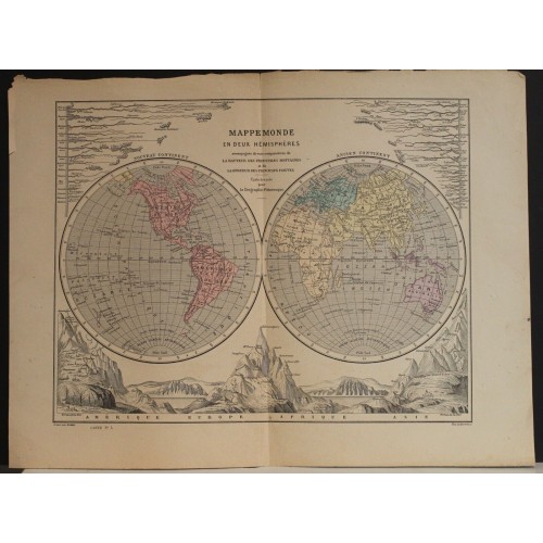
1860ca Edler Antique Original Colored Lithographic World Map In Two Hemispheres
ANTIQUE LITHOGRAPHIC WORLD MAP IN TWO HEMISPHERES 1860c
old times rare books and maps
More from old times rare books and maps (19073)
100% positive
Contact seller
Condition:
--not specified
Ended:
Apr 16, 2023 22:39:31 PDT
Winning bid:
US $23.50
1860ca EDLER ANTIQUE ORIGINAL COLORED LITHOGRAPHIC WORLD MAP IN TWO HEMISPHERES
Description
Mappemonde en deux Hemispheres accompagnйe de vues comparatives de la Hateur des principales Montagnes et de la Longeur des principaux Fleuves Carte dressйe par la Gйographie Pittoresque.
Description: Striking and highly detailed fine unusual original colored lithographic map of the World in two Hemispheres. The map notes rivers, lakes, islands and reliefs. Two comparative tables show yhe heights of Mountains of the World and the lenghts of the world Rivers.
Date: 1860 approx. ( undated )
Dimension: Paper size approx.: cm 38,1 x 28,6
Condition: Very strong and dark impression on good paper. Map old original colored. Wide margins. Corners partially missing. Small foxing and browning. Small tears. Map folded. Conditions are as you can see in the images.
Mapmaker: Pierre M. Lapie (fl. 1779 - 1850) and his son Alexandre Emile Lapie (fl. 1809 - 1850) were French cartographers and engravers active in the early part of the 19th century. The Lapies were commissioned officers in the French army holding the ranks of Colonel and Capitan, respectively. Alexander enjoyed the title of "First Geographer to the King", and this title appears on several of his atlases. Both father and son were exceptional engravers and fastidious cartographers. Working separately and jointly they published four important atlases, an 1811 Atlas of the French Empire (Alexander), the 1812 Atlas Classique et Universel (Pierre), the Atlas Universel de Geographie Ancienne et Modern (joint issue), and the 1848 Atlas Militaire (Alexander). They also issued many smaller maps and independent issues. All of these are products of exceptional beauty and detail. Despite producing many beautiful maps and atlases, the work of the Lapie family remains largely underappreciated by most modern collectors and map historians. The later 19th century cartographer A. H. Dufour claimed to be a student of Lapie, though it is unclear if he was referring to the father or the son. The work of the Lapie firm, with its precise engraving and informational density, strongly influenced the mid-19th century German commercial map publishers whose maps would eventually dominate the continental market.
Armand Joseph Lallemand (c. 1810 - 1871) was an engraver and map publisher based in Paris during the mid-19th century. Most of Lallemand's work focused on landscapes and building vies, though he did take part in a few cartographic ventures, including the production of an atlas with Alexandre Emile Lapie and several tourist pocket maps of Paris.
1860ca Edler Antique Original Colored Lithographic World Map In Two Hemispheres
- Product Code: 3470
- Availability: In Stock
-
$0.00
- Ex Tax: $0.00