
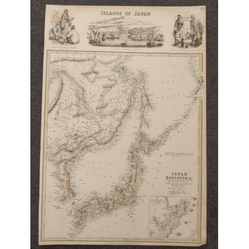
JAPAN CHINA KOREAN PENINSULA 1860 FULLARTON & CO. ANTIQUE LITHOGRAPHIC MAP
Description
Japan, Mandshuria (Showing The Course of the Amur River) The Kurile Isles &c. Accroding to the British & Russian Admiralty Surveys, Krusenstern, Siebold &c. By J: Bartholomew. Jun.r Edin.r.
Description: Striking and highly detailed unusual original colored lithographic map of Japan, China, Korean Peninsula and a part of Russia, engraved by J. Bartholomew and published by Fullarton.
The map is filled with excellent topograhic details on place names, rivers, lakes, relifs and islands.
The map includes large vignettes of the Port of Simoneseke and indigenous Japanese peoples, along with a large inset plan of the Port of Nagasaki.
Date: 1860 ( undated )
Dimension: Paper size approx.: cm 31,8 x 46,8
Condition: Very strong and dark impression on good paper. Plate old 0riginal colored. Short margins. Small foxing and browning. Conditions are as you can see in the images.
Mapmakers: Bartholomew Family (fl. c. 1810 - 1920) is clan of map publishers active in London through the 19th century. They represent one of the great names in British cartography. The cartographic story of the Bartholomew family begins with George Bartholomew (January, 8 1784 - October 23, 1871, active from 1797), an engraver in the employ of the Daniel Lizars firm of Edinburgh. George was the first of six generations in the Bartholomew map-making dynasty. It was his son, John Bartholomew Sr. (1805 - April 9, 1861) who ultimately founded John Bartholomew and Sons in 1828. The John Bartholomew firm produced thousands of maps and rose to become one of the largest and most prolific cartography firms in Scotland. John Sr. was succeeded by his son, also John Bartholomew Jr. (1831-93). John George Bartholomew (1860-1920), son of John Bartholomew (1831-93) took control of the firm at its height. John George was a charter member of the Royal Scottish Geographical Society and supported the creation of a National Institute of Geography - a good idea that never took off. John George is also reliably attributed to be the first to bring the term "Antarctica" into popular usage as a denominator for the Southern Continent. In recognition of his work, John George was awarded a warrant from the king and often used the title "Cartographer to the King" on his imprint. Among his friends and admirers he was referred to as the "Prince of Cartography". John (Ian) Bartholomew (1890 - 1962) continued the family business and oversaw publication of the Times Survey Atlas of the World in 1922 and the Mid Century Edition of the Time Atlas of the World from 1955 - 1960. John Christoper Bartholomew (1923 - 2008) continued the family business into a fifth generation and was fascinated by the natural sciences. He spearheaded the publication of many of the most detailed and popular maps of the last century. His brother Robert, a trained printer, became production director. Another brother, Peter, an accountant, started as a managing director and eventually became executive chairman. The John Bartholomew firm has been part of the HarperCollins family of publishers since 1989. The vast archive of maps and atlases produced by the Bartholomew family has since been transferred to the National Library of Scotland where it is currently in the cataloguing process.
Archibald Fullarton (fl. c. 1809 - 1868) was a Scottish engraver and map publisher active in the first half of the 19th century. Fullerton first began publishing maps in partnership with his friends William Somerville and John Blackie (1782 - 1874), with whom, on November 20 of 1809, he established the Edinburgh Blackie, Fullarton and Co. Around 1831 Fullarton left Blackie, Fullarton, and Company to found his own, independent firm, Fullerton and Co., in Glasgow. Fullarton and Company, which prospered between 1831 and 1850, specialized in Gazetteers and popular regional and world atlases. Fullarton's maps, most of which were copper plate engraving, are considered among the most decorative British maps of his era and included numerous vignettes and other attractive elements.
All of the maps we sell are ORIGINALS. We guarantee all of our maps to be authentic. We do our best to describe the condition of our maps as accurately as possible. Due to the age and type of paper, some imperfections are to be expected. Please examine the images provided carefully, and if you have any questions please ask and we will be happy to help.
A Certification of Authenticity ( COA ) can be issued on request
I will send you all your item by Registered and Insured Airmal or by TNT/DHL with covering Insurance
If you buy more than one item you have to pay just one only shipping cost
Any map purchased from us may be returend for any reason for a full refund.
Shipping: Customs may be charged on international shipments. All customs charges are the responsiblity of the buyer and are not included in the selling price.
About:
Old Times
Rare Antiquarian Books & Maps Sellers
Our Firm was founded in 1983 and we are specialized on antiquarian works on paper concerning Antique Rare Maps, Atlases and Travel Books of all the World.
Our Firm adheres to the Codes of Ethics outlined by the Italian Antiquarian Booksellers Association ( ALAI ) and International League of Antiquarian Booksellers ( ILAB ).
All items sold by OLD TIMES are genuine and a Certificate of Authenticity (COA) will be happily supplied on request.
10127
- Product Code: 10127
- Availability: In Stock
-
$0.00
- Ex Tax: $0.00