
Лист между двумя листами оргалита
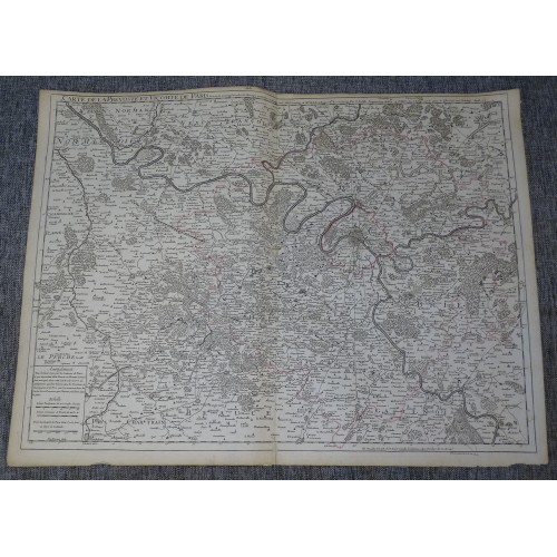
Яркое и очень подробное интересное издание карты Франции Филиппа Бюаша 1745 года с карты Гийома де л'Иль 1711 года. на карте изображен регион Иль-де-Франс, Франция, с центром в Париже, . Карта наполнена отличной топографической информацией о городах, поселках, дорогах и лесах. Заголовок вверху рядом с линией сети и простая шкала пробега и картуш с легендой дополняют карту.
Оригинальное название карты написано наверху:"Crate de la Prevostй et Vicomtй de Paris Dressйe sur un grand nombre de Memoires particuliers assujettie aux observations de M.rs de l'Academie R.le des Sciences Par G. Delisle Premier Geog.e du Eoy. A Paris ... 1711. Ph. Buache P. G. d. R. .... 1745"
Размер листа: 66,1,1 x 51,1 cm
Составители карт: Гийом де л'Иль (1675-1726) был французским картографом и, возможно, лучшим картографом начала восемнадцатого века. Он был главным сторонником школы «позитивной географии» и главной фигурой, определившей стандарты Золотого века французской картографии. Мастерство Гийома как картографа было настолько поразительным, что он нарисовал свою первую карту всего в девять лет. Применяя разнообразные научные дисциплины к информации, предоставленной мореплавателями 18-го века, Гийом создал метод, который стал известен как «научная картография», по сути, расширение «позитивной географии» Сансона. Этот революционный подход изменил картографию и позволил создавать более точную картину мира.
Среди многих нововведений Гийома - первое название Техаса, первая правильная карта Миссисипи, окончательное опровержение заблуждения об островной Калифорнии и первое определение правильной долготы Америки.
Стилистически Де Л'Иль также инициировал важные изменения в картографии, отказавшись от яркого голландского стиля прошлого века в пользу высокодетализированного, и в то же время декоративного подхода, который сделал карту одновременно красивой и информативной.
Гийом был избран во Французскую Королевскую академию наук в 27 лет. Позже, в 1718 году, он также был назначен «Premier Geographe du Roi» - должность, созданная специально для него. Де Лиль лично финансировал публикацию большинства своих карт, надеясь получить большие гонорары от их продажи. К сожалению, он безвременно скончался в 1728 году.
Филипп Бюаш (1700-1773) был французским картографом конца 18 века и издателем карт. Буаш начал свою картографическую карьеру в качестве помощника в мастерской и ученика важного и плодовитого картографа Гийома де Лиля. После безвременной смерти Де Л'Иля Буаш взял на себя издательскую фирму, женившись на дочери Де Л'Иля. За прошедшие годы Бош переиздал многие карты и схемы Де Л'Иля.
В конечном итоге Бюаш был назначен премьер-министром географической географии короля - должность, созданная для Гийома де Л'Иля и ранее занимаемая им. Буаше больше всего уважают за то, что он ввел штриховку как метод отображения подводной высоты на двухмерной поверхности карты. Бюаш составлял карты на основе географических знаний, научных исследований, журналов современных исследователей и миссионеров и прямых астрономических наблюдений. Тем не менее, даже в Париже 18-го века географические знания были сильно ограничены - особенно в отношении неизведанных частей мира, включая полюса, Тихий океан к северо-западу от Америки, а также внутренние районы Африки и Южной Америки.
В этих областях Буаше, как и его главного соперника Робер де Вогонди, следует считать спекулятивным географом или «позитивным географом». Спекулятивная география была жанром составления карт, который развился в Европе, особенно в Париже, в середине-конце 18 века. Картографы этого жанра заполняли неизвестные области на своих картах предположениями, основанными на их личных познаниях в картографии, личных географических теориях и часто сомнительных первоисточниках, собранных исследователями и мореплавателями. Этот подход, который пытался использовать известное для подтверждения неизвестного, естественно, породил много соперничества. Вражда Буаша с другими картографами, особенно с Дидье Робером де Вогонди, привела к тому, что перед Академией наук, членами которой оба были, были представлены многочисленные противоречивые документы. Эпоха спекулятивной картографии фактически закончилась исследованиями капитана Кука, Жана Франсуа де Галаупа де Лаперуза и Джорджа Ванкувера в конце 18 века.
Очень сильный и темный отпечаток на плотной бумаге. Бумага верже. Карта неокрашенная. Поля до верха обрезаны. Широкий нижний край. Широкие боковые поля. Углы частично отсутствуют. Небольшие фоксинги. Карта укреплена на обратной стороне по центральному сгибу. Издательский фальц.
PARIS НLE-DE-FRANCE FRANCE 1745 DE L'ISLE & BUACHE ANTIQUE COPPER ENGRAVED MAP
ANTIQUE COPPER ENGRAVED MAP OF PARIS ОLE-DE-FRANCE 1745
PARIS НLE-DE-FRANCE FRANCE 1745 DE L'ISLE & BUACHE ANTIQUE COPPER ENGRAVED MAP
Description
Crate de la Prevostй et Vicomtй de Paris Dressйe sur un grand nombre de Memoires particuliers assujettie aux observations de M.rs de l'Academie R.le des Sciences Par G. Delisle Premier Geog.e du Eoy. A Paris ... 1711. Ph. Buache P. G. d. R. .... 1745.
Description: Striking and highly detailed interesting 1745 Phillipe Buache's edition of the 1711 Guillaume de l'Isle's copper engraved map centerd on Paris, Оle-de-France region, France. The map is filled with excellent topographic details on cities, towns, roads and forests. A title to the top near netline and a simple mileage scale & legend cartouche complete the map.
Date: 1745 ( dated )
Dimension: Paper size approx.: cm 66,1,1 x 51,1
Condition: Very strong and dark impression on good paper. Paper with chains and wiremark. Map uncolored. Margin to the top cut very shortly. Wide lower margin. Wide lateral margins. Corners partially missing. Small foxing and browning. Small tear at the lower margin near central fold repaired on the verso. Map reinforced on the verso along central fold. Map folded. Conditions are as you can see in the images.
Mapmakers: Guillaume De l’Isle (1675 - 1726) was a French cartographer, and arguably the finest mapmaker at the beginning of the eighteenth century. He was the son of Claude De L'Isle (1644 -1720), a Paris-based historian and geographer under Nicholas Sanson, then the leading light of French cartography. He was the chief proponent of the school of 'positive geography' and the primary figure defining the heights of the Golden Age of French Cartography. Guillaume's skill as a cartographer was so prodigious that he drew his first map at just nine years of age. He was tutored by J. D. Cassini in astronomy, science, mathematics and cartography. By applying these diverse disciplines to the vast stores of information provided by 18th century navigators, Guillaume created the technique that came to be known as 'scientific cartography', essentially an extension of Sanson's 'positive geography'. This revolutionary approach transformed the field of cartography and created a more accurate picture of the world. Among Guillaume's many firsts are the first naming of Texas, the first correct map of the Mississippi, the final rejection of the insular California fallacy, and the first identification of the correct longitudes of America. Stylistically De L'Isle also initiated important changes to the medium, eschewing the flamboyant Dutch style of the previous century in favor of a highly detailed yet still decorative approach that yielded map both beautiful and informative. Guillaume was elected to the French Academie Royale des Sciences at 27. Later, in 1718, he was also appointed 'Premier Geographe du Roi', an office created especially for him. De L'Isle personally financed the publication of most of his maps, hoping to make heavy royalties on their sales. Unfortunately he met an untimely death in 1728, leaving considerable debt and an impoverished child and widow. De L'Isle's publishing firm was taken over by his assistant, Phillipe Buache, who would also become his son in law.
Phillipe Buache (1700 - 1773) was a late 18th century French cartographer and map publisher. Buache began his cartographic career as the workshop assistant and apprentice to the important and prolific cartographer Guillaume de L'Isle. Upon De L'Isle's untimely death, Buache took over the publishing firm cementing the relationship by marrying De L'Isle's daughter. Over the years, Bauche republished many of De L'Isle's maps and charts. Buache was eventually appointed Premier Geographe du Roi, a position created-for and previously held by Guillaume de L'Isle. Buache is most respected for his introduction of hachuring as a method from displaying underwater elevation on a two dimensional map surface. Buache compiled maps based upon geographic knowledge, scholarly research, the journals of contemporary explorers and missionaries, and direct astronomical observation. Nevertheless, even in 18th century Paris geographical knowledge was severely limited - especially regarding those unexplored portions of the world, including the poles, the Pacific northwest of America, and the interior of Africa and South America. In these areas the Buache, like his primary rival Robert de Vaugondy, must be considered a speculative geographer or 'positive geographer'. Speculative geography was a genre of mapmaking that evolved in Europe, particularly Paris, in the middle to late 18th century. Cartographers in this genre would fill in unknown areas on their maps with speculations based upon their vast knowledge of cartography, personal geographical theories, and often dubious primary source material gathered by explorers and navigators. This approach, which attempted to use the known to validate the unknown, naturally engendered many rivalries. Buache's feuds with other cartographers, most specifically Didier Robert De Vaugondy, resulted in numerous conflicting papers being presented before the Academie des Sciences, of which both were members. The era of speculatively cartography effectively ended with the late 18th century explorations of Captain Cook, Jean Francois de Galaup de La Perouse, and George Vancouver. Buache was succeeded by his nephew Jean-Nicholas Buache de Neuville.
10100
- Product Code: 10100
- Availability: In Stock
-
$0.00
- Ex Tax: $0.00