
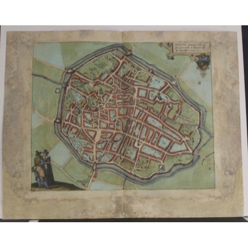
DOUAI FRANCE 1581 BRAUN & HOGENBERG UNUSUAL ANTIQUE COPPER ENGRAVED CITY VIEW
ANTIQUE COPPER ENGRAVED CITY VIEW OF DOUAI FRANCE 1581
old times rare books and maps
(20116)
100% positiveSeller's other itemsSeller's other itemsContact seller
US $112.50
DOUAI FRANCE 1581 BRAUN & HOGENBERG UNUSUAL ANTIQUE COPPER ENGRAVED CITY VIEW
Description
Douay. == Duacum, Catuacorum Urbs, tam situ, quam incolis, et litterarum studijs elegantissime ornata.
Description: Striking and highly detailed fine unusual copper engraved map featuring a bird's-eye plan of Douai, France. The plan shows the city with his buildings, churches, streets, gardens, town walls and surrounding landscape. An ornate lettered key cartouche, a simple title st the top central side, an Armorial and two inhabitants in their typical dresses adorn the view. Latin text on verso.
TRANSLATION OF CARTOUCHE TEXT: Duacum, the town of the Catuaci, is most beautifully embellished by its appearance, inhabitants and university.
COMMENTARY BY BRAUN: "Douai, situated on the border of Flanders, Hainaut and Artois, is such a well-built and well-fortified city thanks to its thick ring walls that its equal is hard to find. [...] The city has an extremely good system of government, which distinguished it from other cities. They recognize the king as their supreme regent; as a result of the admirable wisdom of their ancestors, they appoint two mayors, one of whom presides over the magistrate, while the other is responsible for civic matters. Both offices are hereditary.."
Douai on the River Scarpe is seen in a bird's-eye view from the east. The narrow streets are outlined schematically by uninterrupted chains of houses. This schematic style of illustration also extends to the churches and other major buildings, including the town hall with its lofty belfry and the largest carillon in Europe; the Porte de Valenciennes in the east; the nearby Gothic church of Notre-Dame; Douai's oldest church, the Collegiale Saint-Pierre; and lastly the Gothic church of Saint-Jacques in the west. Douai passed to Burgundy in 1384 and to the Spanish Netherlands in 1477.
Braun G. & Hogenberg F. and the Civitates Orbis Terrarum.
The Civitates Orbis Terrarum, or the "Braun & Hogenberg", is a six-volume town atlas and the greatest book of town views and plans ever published: 363 engravings, sometimes beautifully coloured. It was one of the best-selling works in the last quarter of the 16th century. Georg Braun wrote the text accompanying the plans and views on the verso. A large number of the plates were engraved after the original drawings of Joris Hoefnagel (1542-1600), who was a professional artist. The first volume was published in Latin in 1572, and the sixth in 1617. Frans Hogenberg created the tables for volumes I through IV, and Simon van den Neuwel created those for volumes V and VI. Other contributors were cartographers Daniel Freese and Heinrich Rantzau. Works by Jacob van Deventer, Sebastian Mьnster, and Johannes Stumpf were also used. Translations appeared in German and French.
Following the original publication of Volume 1 of the Civitates in 1572, seven further editions of 1575, 1577, 1582, 1588, 1593, 1599 and 1612 can be identified. Vol.2, first issued in 1575, was followed by further editions in 1597 and in 1612. The next volumes appeared in 1581, 1588, 1593, 1599 and 1606. The German translation of the first volume appeared from 1574 on, and the French edition from 1575 on.
Several printers were involved: Theodor Graminaeus, Heinrich von Aich, Gottfried von Kempen, Johannis Sinniger, Bertram Buchholtz and Peter von Brachel, who all worked in Cologne.
Date: 1581 ( undated )
Dimension: Paper size approx.: cm 52,4 x 41,8
Condition: Very strong and dark impression on good paper. Paper with chains. Plate old original colored. Wide margins. Corners partially missing and redone. Small foxing and browning. Small holes partially restored. Small tears. Sheet reinforced with contemporary paper. Plate folded. Conditions are as you can see in the images.
Mapmakers: Georg Braun (also Brunus, Bruin; 1541 – 10 March 1622) was a topo-geographer. From 1572 to 1617 he edited the Civitates orbis terrarum, which contains 546 prospects, bird's-eye views and maps of cities from all around the world. He was the principal editor of the work, he acquired the tables, hired the artists, and wrote the texts. He died as an octogenarian in 1622, as the only survivor of the original team to witness the publication of volume VI in 1617.
Braun was born and died in Cologne. His principal profession was as a Catholic cleric, however, he spent thirty-seven years as canon and dean at the church, St. Maria ad Gradus, in Cologne. His six-volume work was inspired by Sebastian Mьnster's Cosmographia. In form and layout it resembles the 1570 Theatrum orbis terrarum by Abraham Ortelius, as Ortelius was interested in a complementary companion for the Theatrum.
The Braun publication set new standards in cartography for over 100 years. Frans Hogenberg (1535–1590, from Mechelen) created the tables for volumes I through IV, and Simon van den Neuwel created those for volumes V and VI. Other contributors were Joris Hoefnagel, Jacob Hoefnagel, cartographer Daniel Freese, and Heinrich Rantzau. Works by Jacob van Deventer, Sebastian Mьnster, and Johannes Stumpf were also used. Primarily European cities are depicted in the publication; however, Casablanca and Mexico City/Cuzco on one sheet[4] are also included in volume I.
Frans Hogenberg (1535–1590) was a Flemish and German painter, engraver, and mapmaker.
Hogenberg was born in Mechelen as the son of Nicolaas Hogenberg. In 1568 he was banned from Antwerp by the Duke of Alva and travelled to London, where he stayed a few years before emigrating to Cologne. He is known for portraits and topographical views as well as historical allegories. He also produced scenes of contemporary historical events.
Hogenberg died in Cologne.
12173
- Product Code: 12173
- Availability: In Stock
-
$0.00
- Ex Tax: $0.00