
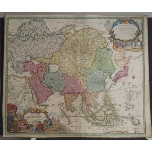
ASIAN CONTINENT 1716ca JOHANN BAPTIST HOMANN UNUSUAL ANTIQUE COPPER ENGRAVED MAP
ANTIQUE COPPER ENGRAVED MAP OF ASIAN CONTINENT 1716ca
old times rare books and maps
(20116)
100% positiveSeller's other itemsSeller's other itemsContact seller
US $222.50
ASIAN CONTINENT 1716ca JOHANN BAPTIST HOMANN UNUSUAL ANTIQUE COPPER ENGRAVED MAP
Description
Asiae Recentissima Delineatio, qua Status et Imperia totius Orientis unacum Orientalibus Indiis exhibentur Ioh. Bapt. Homanno Nurenberg.
Description: Striking and highly detailed fine unusual 1716ca. Johann Baptist Homann's copper engraved first map of Asia, extending from the Mediterranean to the Pacific and including parts of Nova Hollandia, Carpentaria, Nova Britannia and the Marianas, along with a nice incomplete version of the mythical Compagnie Land, north of Japan. Still without Kamchatka, but with the big island of Terra Yedso above Japan.
Korea or Corea is present if misshapen in roughly the correct location. Further south New Guinea, New Britannia, Australia (New Holland), Hoch Land, and Carpentaria (part of Australia), are personated in tentative form with largely unexplored boundaries.
The map is filled with excellen topographic details on cities, towns, rivers, lakes. deserts, reliefs and islands.
Bottom left quadrant features a decorative title cartouche displaying an enthroned king in Middle Eastern or Indian garb, exotic animals including a lion and leopard, trade goods, Camels, and bowing supplicants.
This edition of the map includes an ornate second cartouche in the upper right corner of the map. In later editions, the cartouche is removed and the coastal features above Japan along the NE Coast of Asia are significantly revised. There are also small changes in the mapping of Carpentaria.
Dampier's passage north of Carpentaria is noted, along with Arnham's Land and Vay van Diemen on the continent of Nova Hollandia. Nova Britannia appears to have been detected by William Dampier in 1700. Several place names appear in Carpentaria.
North Pacific chimeras: Yesso, De Gama, and Compagnie Land
The etymology of the idiom Yesso (Eso, Yeco, Jesso, Yedso) is most likely the Japanese Ezo-chi; a term used for the lands north of the island of Honshu. During the Edo period (1600-1886), it came to represent the ‘foreigners’ on the Kuril and Sakhalin islands. As European traders came into contact with the Japanese in the seventeenth century, the term was transferred onto European maps, where it was often associated with the island of Hokkaido. It varies on maps from a small island to a near-continent sized mass that stretches from Asia to Alaska.
The toponym held interest for Europeans because the island was supposedly tied to mythic riches. Father Francis Xavier (1506-1552), an early Jesuit missionary to Japan and China, related stories that immense silver mines were to be found on a secluded Japanese island; these stories were echoed in Spanish reports. The rumors became so tenacious and tantalizing that Abraham Ortelius included an island of silver north of Japan on his 1589 map of the Pacific.
Yesso is often tied to two other mythical North Pacific lands, Gamaland and Compagnies Land. Juan de Gama, the grandson of Vasco de Gama, was a Portuguese navigator who was accused of illegal trading with the Spanish in the East Indies. Gama fled and sailed from Macau to Japan in the later sixteenth century. He then struck out east, across the Pacific, and supposedly saw lands in the North Pacific. These lands were initially shown as small islands on Portuguese charts, but ballooned into a continent-sized landmass in later representations.
Several voyagers sought out these chimerical islands, including the Dutchmen Matthijs Hendrickszoon Quast in 1639 and Maarten Gerritszoon Vries in 1643. Compagnies Land, often shown along with Staten Land, were islands sighted by Vries on his 1643 voyage. He named the islands for the Dutch States General (Staten Land) and for the Dutch East India Company (VOC) (Compagnies, or Company’s Land). In reality, he had re-discovered two of the Kuril Islands. However, other mapmakers latched onto Compagnies Land in particular, enlarging and merging it with Yesso and/or Gamaland.
In the mid-eighteenth century, Vitus Bering, a Danish explorer in Russian employ, and later James Cook would both check the area and find nothing. La Perouse also sought the huge islands, but found only the Kurils, putting to rest the myth of the continent-sized dream lands.
Date: 1716ca ( undated )
Dimension: Map size approx.: cm 60,1 x 50,9
Condition: Very strong and dark impression on good paper. Paper with chains and wiremarks. Map old original colored. Title cartouche contemporary handcolored. Small margins. Small foxing and browning. Map folded. Conditions are as you can see in the images.
Mapmakers: Johann Baptist Homann (March 20, 1664 - July 1, 1724) was the most prominent and prolific map publisher of the 18th century. Homann was born in Oberkammlach, a small town near Kammlach, Bavaria, Germany. As a young man Homann studied in a Jesuit school and nursed ambitions of becoming a Dominican priest before converting to Protestantism in 1687. Following his conversion, Homann moved to Nuremberg and found employment as a notary. Around 1693 Homan briefly relocated to Vienna, where he lived and studied printing and copper plate engraving until 1695. Afterwards he returned to Nuremberg where, in 1702, he founded the commercial publishing firm that would bear his name. In the next five years Homann produced hundreds of maps and developed a distinctive style characterized by heavy detailed engraving, elaborate allegorical cartouche work, and vivid hand color. The Homann firm, due to the lower cost of printing in Germany, was able to undercut the dominant French and Dutch publishing houses while matching the diversity and quality of their output. By 1715 Homann's rising star caught the attention of the Holy Roman Emperor Charles the VI, who appointed him Imperial Cartographer. In the same year he was also appointed a member of the Royal Academy of Sciences in Berlin. Homann's prestigious title came with a number of important advantages including access to the most up to date cartographic information as well as the "Privilege". The Privilege was a type of early copyright offered to a few individuals by the Holy Roman Emperor. Though not as sophisticated as modern copyright legislation, the Privilege did offer a kind of limited protection for several years. Most all J. B. Homann maps printed between 1715 and 1730 bear the inscription "Cum Priviligio" or some variation. Following Homann's death in 1726, the management of the firm passed to his son Johann Christoph Homann (1703 - 1730). J. C. Homann, perhaps realizing that he would not long survive his father, stipulated in his will that the company would be inherited by his two head managers, Johann Georg Ebersberger and Johann Michael Franz, and that it would publish only under the name Homann Heirs. This designation, in various forms (Homannsche Heirs, Heritiers de Homann, Lat Homannianos Herod, Homannschen Erben, etc..) appears on maps from about 1731 onwards. The firm continued to publish maps in ever diminishing quantities until the death of its last owner, Christoph Franz Fembo in 1848.
12169
- Product Code: 12169
- Availability: In Stock
-
$0.00
- Ex Tax: $0.00