
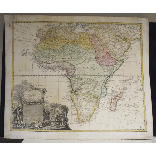
AFRICAN CONTINENT 1737 HOMANN HEIRS & HAAS UNUSUAL ANTIQUE COPPER ENGRAVED MAP
ANTIQUE COPPER ENGRAVED MAP OF THE AFRICAN CONTINENT
old times rare books and maps
(20116)
100% positiveSeller's other itemsSeller's other itemsContact seller
US $231.50
AFRICAN CONTINENT 1737 HOMANN HEIRS & HAAS UNUSUAL ANTIQUE COPPER ENGRAVED MAP
Description
Africa Secundum legitimas Projectionis Stereographicae regulas et juxta recentissimas et relationes et observationes in subsidium vocatis quoque veterum Leonis Africani Nubiensis Geographi et alioru monumentis et eliminates fabulosis aliorum designationibus pro prasenti statue ejus aptius exhibita а Ioh. Matthia Hasio M.P.R.O. h. t. Facult. Phil. in Acad. Witeb. Decano Impensis Homannianorum Heredum. S. P. C. S. M.
Description: Striking and highly detailed fine unusual 1737 Homann Heirs's copper engraved map of Africa, augmented to include important cartographic developments as recorded by Guillaume Delisle and D’Anville.
The map presents a fairly accurate picture without most of the fictitious lakes and rivers of previous cartography, focusing on the known coastal regions of the continent, leaving the interior blank or marked Terra Incognito. Egypt, Nubia and Abyssinia are shown as distinct entities, Lake Nyasa is shown as Lac Marawi, and the Congo is located. The Dutch settlements of Castell Batov and Stellenbosch are shown at the Cape.
The most striking feature of the map is the large title cartouche that is framed by elephant tusks and a horned serpent. In the foreground is a scene of natives negotiating with European traders, surrounded by indigenous animals. In the background is a view of Table Bay and Table Mountain.
Date: 1737 ( undated )
Dimension: Map size approx.: cm 61,1 x 52,1
Condition: Very strong and dark impression on good paper. Paper with chains and wiremarks. Map old original colored. Wide margins. Top left margin partially redone. Small foxing. Small tears restored. Map washed and retsored. Map folded. Conditions are as you can see in the images.
Mapmakers: Johann Baptist Homann (March 20, 1664 - July 1, 1724) was the most prominent and prolific map publisher of the 18th century. Homann was born in Oberkammlach, a small town near Kammlach, Bavaria, Germany. As a young man Homann studied in a Jesuit school and nursed ambitions of becoming a Dominican priest before converting to Protestantism in 1687. Following his conversion, Homann moved to Nuremberg and found employment as a notary. Around 1693 Homan briefly relocated to Vienna, where he lived and studied printing and copper plate engraving until 1695. Afterwards he returned to Nuremberg where, in 1702, he founded the commercial publishing firm that would bear his name. In the next five years Homann produced hundreds of maps and developed a distinctive style characterized by heavy detailed engraving, elaborate allegorical cartouche work, and vivid hand color. The Homann firm, due to the lower cost of printing in Germany, was able to undercut the dominant French and Dutch publishing houses while matching the diversity and quality of their output. By 1715 Homann's rising star caught the attention of the Holy Roman Emperor Charles the VI, who appointed him Imperial Cartographer. In the same year he was also appointed a member of the Royal Academy of Sciences in Berlin. Homann's prestigious title came with a number of important advantages including access to the most up to date cartographic information as well as the "Privilege". The Privilege was a type of early copyright offered to a few individuals by the Holy Roman Emperor. Though not as sophisticated as modern copyright legislation, the Privilege did offer a kind of limited protection for several years. Most all J. B. Homann maps printed between 1715 and 1730 bear the inscription "Cum Priviligio" or some variation. Following Homann's death in 1726, the management of the firm passed to his son Johann Christoph Homann (1703 - 1730). J. C. Homann, perhaps realizing that he would not long survive his father, stipulated in his will that the company would be inherited by his two head managers, Johann Georg Ebersberger and Johann Michael Franz, and that it would publish only under the name Homann Heirs. This designation, in various forms (Homannsche Heirs, Heritiers de Homann, Lat Homannianos Herod, Homannschen Erben, etc..) appears on maps from about 1731 onwards. The firm continued to publish maps in ever diminishing quantities until the death of its last owner, Christoph Franz Fembo in 1848.
Johann Matthias (Matyhias) Haas (Hasio, Haase) (Latinized as Johannes Hasius) (January 14, 1684 - September 24, 1742) was a German mathematician, astronomer, and cartographer. Haas was born in Augsburg but is known to have held academic positions in Nuremburg, Leipzig and Wittenberg, where he was a professor of mathematics. He produced several maps for the Homann Heirs firm in addition to several publications of his own. Today is memorialized by a crater on the Moon - Hase Crater.
Антикварная Карта Америки Иоганна Хоманна
Северная и Южная Америка - старинная карта с пышными картушами, Иоганн Хоманн, 1744.
Картограф: Иоганн Баптист Хоманн
Год издания: после 1744
Место публикации: Нюрнберг
Язык: латынь
Размер листа (см): 62,1 x 53,2
Date: 1746 ( dated )
Настоящая карта Северной и Центральной Америки происходит из Atlas minor XXXVI. Tabularum Hommanianarum (лист 34), опубликованном Иоганном Баптистом Хоманном в начале XVIII века и впоследствии неоднократно переиздававшемся в течение столетия.
Карта демонстрирует некоторую архаичность географических знаний об отображенном регионе: Калифорния показана в виде острова, мифический Анианов пролив образует Северо-Западный проход между первой и «TerraEsonis» (своеобразный аналог terraincognita), формируя длинную сухопутную связку между западным побережьем Америки и Азией. Тем не менее, система Великих озер отражена с большой долей детализации. Река Миссисипи показана в соответствии с изысканиями ранних французских экспедиций ордена иезуитов: ее истоки уходят на север гораздо дальше, чем это было принято в картографии на 20-30 лет ранее. Однако несуществующее в природе озеро Лемойн все еще фиксируется на представленной карте в юго-восточной территории Соединенных Штатов.
Карта украшена двумя роскошными картушами, содержащими в себе титул (нижний) и легенду (верхний).
Сложные орнаментальные рамы фланкируются фигурными композициями, отражающими европоцентричные взгляды на колонизацию материка. Они демонстрируют взору зрителя прибытие экспедиции Колумба и обращение местных жителей в новую веру (в противовес языческому тотемизму).
За образец титульного картуша Хоманном был взят тот, что украшал карту Николя де Фера 1699 года, за образец картуша, содержащего легенду – тот, что использовал Гийом Делиль в своей карте Канады 1703 года выпуска.
Иоганн Баптист Хоманн (1663-1724) – знаменитый немецкий картограф и гравер, базировавшийся в Нюрнберге. До обращения в протестантизм Хоманн стремился сделать карьеру священника. В 1702 году он основал издательство, специализировавшееся на публикации гравюр, однако славу ему принесло издательство карт, превратившее фирму Хоманна в одну из самых знаменитых в Германии и востребованных во всей Европе. В 1715 году картограф приобрел титул Географа правителя Священной Римской империи (от Карла VI) и был избран в члены прусской Академии Наук. Покровительство и привилегии от императора обеспечили фирме Хоманна прочное положение на рынке и авторитет в академических кругах. Наиболее известным проектом картографа стал Большой Атлас Мира, опубликованный в 1716 году. После смерти Хоманна издательство перешло в руки его наследников, продолжая существовать таким образом вплоть до середины XIX столетия.
Карта является значительным памятником картографии раннего XVIII века и представляет большой интерес как с научной, так и с эстетической точки зрения.
12164
- Product Code: 12164
- Availability: In Stock
-
$0.00
- Ex Tax: $0.00