
List on Ebay
BOX 21-01-25
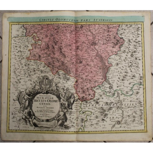
COUNTY OF OLOMUC CZECH REPUBLIC 1720 HOMANN UNUSUAL ANTIQUE COPPER ENGRAVED MAP
ANTIQUE COPPER ENGRAVED MAP OF COUNTY OF OLOMUC 1720
old times rare books and maps
old times rare books and maps
(19538)
100% positiveSeller's other itemsSeller's other itemsContact seller
US $78.77
COUNTY OF OLOMUC CZECH REPUBLIC 1720 HOMANN UNUSUAL ANTIQUE COPPER ENGRAVED MAP
Description
Marchionatus Moraviae Circulus Olomucensis quem mandato Cжsareo accuratи emensus hac mappa delineatum exhibet Jo. Chr. Mьller S.C.M. Cap. et Ingen. Editore Joh. Baptista Homann Norimbergж Cum Privilegio Sac. Cжs. Majestatis. // Circuli Olomucensis Pars Australis.
Description: Striking and highly detailed fine unusual 1720 Johann Baptist Homann's copper engraved map of the region of Olomuc in Moravia, now in Czech Republic. The map is graphically engraved to illustrate cities, towns, villages, rivers, forests and reliefs. A large figurate cartocuhe includes the title. The map is based on the work of Johann Christoph Muller.
Johann Christoph Mьller (Wцhrd, March 15, 1673 - Vienna, June 21, 1721) was a German cartographer and engineer who worked for the Austrian administration. Johann Christoph Mьller was the son of Johann Mьller, a school teacher in Wцhrd, a town near Nuremberg, of which it is now a district, and Ursula Luft. His brother Johann Heinrich Mьller (1671–1731) was an astronomer. From 1692 to 1696, Mьller was, as his first brother, assistant to Georg Christoph Eimmart at the Nьrnberger Sternwarte; he was then placed in the public administration by Luigi Ferdinando Marsigli. He had created numerous sketches during the war against the Turks in Eastern Europe and was looking for a collaborator to draw up the maps. From the collaboration between Mьller and Marsigli emerged the first reasonably accurate map of Hungary. Until then, the Danube east of Esztergom had never been shown on maps. The first accurate maps of Bohemia and Moravia were also produced by Mьller. In 1703 Marsigli was dishonorably discharged from the army. About 300 maps were drawn up by Mьller, who was one of the most important cartographers of Austria and Hungary. Johann Christoph Mьller died in 1721 unmarried and childless.
Date: 1720 ( undated )
Dimension: Map size approx.: cm 61,3 x 52,8
Condition: Very strong and dark impression on good paper. Paper with chains and wiremarks. Map old original colored. Wide margins. Corners partially missing. Small foxing and browning. Small waterstains. Map folded. Conditions are as you can see in the images.
Mapmakers: Johann Baptist Homann (March 20, 1664 - July 1, 1724) was the most prominent and prolific map publisher of the 18th century. Homann was born in Oberkammlach, a small town near Kammlach, Bavaria, Germany. As a young man Homann studied in a Jesuit school and nursed ambitions of becoming a Dominican priest before converting to Protestantism in 1687. Following his conversion, Homann moved to Nuremberg and found employment as a notary. Around 1693 Homan briefly relocated to Vienna, where he lived and studied printing and copper plate engraving until 1695. Afterwards he returned to Nuremberg where, in 1702, he founded the commercial publishing firm that would bear his name. In the next five years Homann produced hundreds of maps and developed a distinctive style characterized by heavy detailed engraving, elaborate allegorical cartouche work, and vivid hand color. The Homann firm, due to the lower cost of printing in Germany, was able to undercut the dominant French and Dutch publishing houses while matching the diversity and quality of their output. By 1715 Homann's rising star caught the attention of the Holy Roman Emperor Charles the VI, who appointed him Imperial Cartographer. In the same year he was also appointed a member of the Royal Academy of Sciences in Berlin. Homann's prestigious title came with a number of important advantages including access to the most up to date cartographic information as well as the "Privilege". The Privilege was a type of early copyright offered to a few individuals by the Holy Roman Emperor. Though not as sophisticated as modern copyright legislation, the Privilege did offer a kind of limited protection for several years. Most all J. B. Homann maps printed between 1715 and 1730 bear the inscription "Cum Priviligio" or some variation. Following Homann's death in 1726, the management of the firm passed to his son Johann Christoph Homann (1703 - 1730). J. C. Homann, perhaps realizing that he would not long survive his father, stipulated in his will that the company would be inherited by his two head managers, Johann Georg Ebersberger and Johann Michael Franz, and that it would publish only under the name Homann Heirs. This designation, in various forms (Homannsche Heirs, Heritiers de Homann, Lat Homannianos Herod, Homannschen Erben, etc..) appears on maps from about 1731 onwards. The firm continued to publish maps in ever diminishing quantities until the death of its last owner, Christoph Franz Fembo in 1848.
10874
- Product Code: 10874
- Availability: In Stock
-
$0.00
- Ex Tax: $0.00