
PALACE OF WHITEHALL LONDON ENGLAND 1743 SALMON ANTIQUE COPPER ENGRAVED VIEW See original listing
PALACE OF WHITEHALL LONDON ENGLAND 1743 SALMON ANTIQUE COPPER ENGRAVED VIEW
Item Sold
Condition:--
Ended:Jan 25, 2022 , 8:01AM
Winning bid:US $40.00
Approximately 3,070.55 RUB
[ 7 bids ]
PALACE OF WHITEHALL LONDON ENGLAND 1743 SALMON ANTIQUE COPPER ENGRAVED VIEW
Description
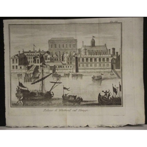
Palazzo di Whitehal sul Tamigi.
Description: Striking and highly detailed interesting 1743 Thomas Salmon's copper engraved view of the Palace of Whitehall at Wstminster, London, England, United Kingdom. Several ships on the Thames Rives and several inhabitans complete the sheet.
The Palace of Whitehall (or Palace of White Hall) at Westminster, Middlesex, was the main residence of the English monarchs from 1530 until 1698, when most of its structures, except notably Inigo Jones's Banqueting House of 1622, were destroyed by fire. Henry VIII moved the royal residence to White Hall after the old royal apartments at the nearby Palace of Westminster were themselves destroyed by fire. Although the Whitehall palace does not survive, the area where it was located is still called Whitehall and has remained a centre of government.
White Hall was at one time the largest palace in Europe, with more than 1,500 rooms, overtaking the Vatican, before itself being overtaken by the expanding Palace of Versailles, which was to reach 2,400 rooms. The palace gives its name, Whitehall, to the street located on the site on which many of the current administrative buildings of the present-day British government are situated, and hence metonymically to the central government itself. At its most expansive, the palace extended over much of the area bordered by Northumberland Avenue in the north; to Downing Street and nearly to Derby Gate in the south; and from roughly the elevations of the current buildings facing Horse Guards Road in the west, to the then banks of the River Thames in the east (the construction of Victoria Embankment has since reclaimed more land from the Thames)—a total of about 23 acres (9.3 ha). It was about 710 yards (650 m) from Westminster Abbey.
Date: 1743 ( undated )
Dimension: Paper size approx.: cm 24,8 x 19,2
Condition: Very strong and dark impression on good paper. Paper with chains and wiremarks. Map uncolored. Goodmargin to the top. Good lower margin. Wide right lateral margins. Quitee left lateral margin. Corners partially missing. Small holes inside the view. Plate folded. Conditions are as you can see in the images.
Mapmaker: Thomas Salmon (1679–1767) was an English historical and geographical writer. Born at Meppershall in Bedfordshire, and baptised there on 2 February 1679, was son of Thomas Salmon, by his wife Katherine, daughter of John Bradshaw; Nathanael Salmon was his elder brother. William Cole wrote that he wrote much of his work in Cambridge, where he ran a coffee house, and then moved to London. He told Cole that he had spent time at sea, and in both the East and West Indies for some time. He also travelled in Europe. In 1739–40 Salmon accompanied George Anson on his voyage round the world. He died on 20 January 1767.
9719
- Product Code: 9719
- Availability: In Stock
-
$0.00
- Ex Tax: $0.00