
SEA OF AZOF & BLACK SEA CRIMEA RUSSIA UKRAINE 1784 DELESPINASSE ANTIQUE MAP
ANTIQUE COPPER ENGRAVED MAP OF SEA OF AZOF & BLACK SEA
Condition:
--not specified
Ended:Jul 17, 2022 , 7:05AM
Winning bid:
US $23.00
SEA OF AZOF & BLACK SEA CRIMEA RUSSIA UKRAINE 1784 DELESPINASSE ANTIQUE MAP
Description
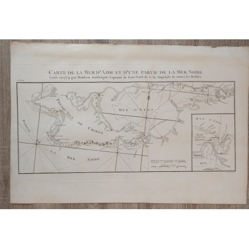
Carte de la Mer d'Azof et d'une partie de la Mer Noire Levйe en 1774 par Monsieur Kinsbergen, Capitaine de haut-bord de S.M. Impйriale de toutes les Russies.
Description: Striking and highly detailed fine unusual large copper engraved map of the Crimean Peninsula with the Black Sea and the Sea of Azov in Russia. The map is filled with excellant topographic details on place names, depth and soundings. Inset map at the lower right quadrant titled "Plan du Dйtroit de Zabache". A title to the top, two mileage scales, a fleur-de-lis and rhumb lines adorn the map.
The map, engraved by Pierre Franзois Tardieu, is based upon the Jan-Hendrki Van Kinsbergen's map.
Jan-Hendrki Van Kinsbergen's map of Crimea was the first printed map of the Crimea, following its annexation by Russia.
The first edition of Van Kinsbergen's map appeared in 1776. The map is based on observations made by Van Kinsbergen and the Russian Navy, shortly after the conclusion of the Russian-Turkish War, and includes a remarkable amount of topographical detail. During the Russian-Turkish war of 1768-1774, and again in 1783 in connection with the annexation of the Crimea, an intensive effort to map the Black Sea was conducted by the Russian Navy. Among the earliest maps to derive from this work is Jan-Hendrik Van Kinsbergen's map of the Crimea, first published in 1776.
Captain Jan Hendrik van Kinsbergen (1735-1819) was a Dutch officer invited by Catherine II to serve in the Russian Navy. During her service from 1770-75, he fought the Turks, becoming known as the "Hero of the Black Sea," as a result of his important victory in 1773 against a much larger Turkish force. During this war, Russia took the Crimea, and one of the duties of Jan Hendrik van Kinsbergen, as laid out by Peter the Great, founder of the Russian Navy, was making charts of the newly conquered land. During this time, he produced a number of maps which were later published from Russian sources, of which this 4-sheet map is perhaps the best known and most important. Van Kinsbergen's superlative map of Crimea is a work whose quality far exceeded the expectations of his mandate as Captain for the Russian Navy.
Source: Nicolas-Gabriel Le Clerc. Histoire physique, morale, civile et politique de la Russie ancienne & moderne. Paris & Versailles: Froullй & Blaizot, 1783-1794.
References: Cohen/Ricci, 613; Brunet, III, 916; Lewine S., 302; Sander, 1138.
Date: 1784 ( undated )
Dimension: Paper size approx.: cm 49,2 x 32,9
Condition: Very strong and dark impression on good paper. Paper with chains and wiremarks. Sheet uncolored. Wide top and lower margins. Good right lateral margins. Left lateral margin cut very shortly. Corners partially missing. Small foxing and browning. Conditions are as you can see in the images.
Writer: Louis-Nicolas de Lespinasse (1734 -1808), called the Chevalier de Lespinasse , has been a French Artist.
Mapmakers: Pierre Franзois Tardieu (1711 - 1771) was a French engraver and mapmaker active in Paris during the middle part of the 18th century and a member of the large and prolific Tardieu family. Several members of the family established themselves as engravers, and, for over 200 years, the family produced works. Pierre Francois Tardieu was born around 1711 in Paris, son of Jean Tardieu. His uncle, Nicolas-Henry Tardieu, taught him the art of engraving. Pierre was a general engraver whose work was not limited to maps but also included historical and genre works. Many of his maps are extremely significant and include some of the finest French productions of the period. Tardieu had his office at Rue de al Corderie, Paris. Tardieu was married to Marie-Anne Rousselet (1733-1826), whose family included the engraver Gilles Rousselet and the sculptor Jean Rousselet. It is highly likely that Pierre Francois Tardieu was succeeded by Pierre Antoine Francois Tardieu (1757 - 1822), who is also possibly his son, as the latter continued to engrave under the P. F. Tardieu imprint well after the former's death.
Оригинальная карта (резцовая гравюра) - оттиск с медной доски - по рисунку г. Ш. де Леспинасе. Гравировал Нике, под руководством Ф.-Д. Нее.
Гравюра из атласа к изданию А.Ф. Леклерка «Физическая, моральная, гражданская и политическая история современной России» (Париж, 1783-1784). (Nicolas-Gabriel Le Clerc. Histoire physique, morale, civile et politique de la Russie ancienne & moderne. Paris & Versailles: Froullй & Blaizot, 1783-1794.)
References: Cohen/Ricci, 613; Brunet, III, 916; Lewine S., 302; Sander, 1138.
Оригинальное название - Carte de la Mer d'Azof et d'une partie de la Mer Noire Levйe en 1774 par Monsieur Kinsbergen, Capitaine de haut-bord de S.M. Impйriale de toutes les Russies.
Гравюра выполнена по оригиналу французского художника Луи Николя Леспинаса (1734-1808) известным мастером гравюры Франсуа-Дени Нее (1732-1817) для альбома к популярному в XVIII веке сочинению Леклерка. В атлас входило 38 сложенных гравюр, карт, планов.
Date: 1784 ( undated )
Представленные в атласе города Российской империи были наиболее известными для своего времени. В атлас включались виды городов Сибири, а также Петербурга, Твери, Новгорода, Казани, Кронштадта и планы Петербурга и Москвы.
Во второй половине XVIII века эти изображения были, безусловно, одними из первых и наиболее достоверных, поскольку отражали своеобразие пейзажа и этнографические особенности одежды местного населения, что соответствовало восприятию иностранцами России как экзотической страны. Атлас содержал 56 гравированных листов с панорамными видами Санкт-Петербурга, включая уникальный план Санкт-Петербурга, гравированный П. Ф. Тардье, план Москвы, виды городов Тобольска, Екатеринграда, Якутска и др. Гравюры, вошедшие в состав атласа, были выполнены выдающимися мастерами французской школы гравировального искусства - одной из самых интересных и сильных в XVIII в. Во второй половине XVIII в. эти изображения городов России стали одними из первых и наиболее достоверных.
В хорошем состоянии - см фото.
Бумага верже с водяными знаками.
Размер листа cm 49,2 x 32,6, размер изображения 36 x 28 cm - Обратная сторона чистая
?20000 rub
10707
10707
- Product Code: 10707
- Availability: In Stock
-
$0.00
- Ex Tax: $0.00