
Между двух кусков оргалита!!
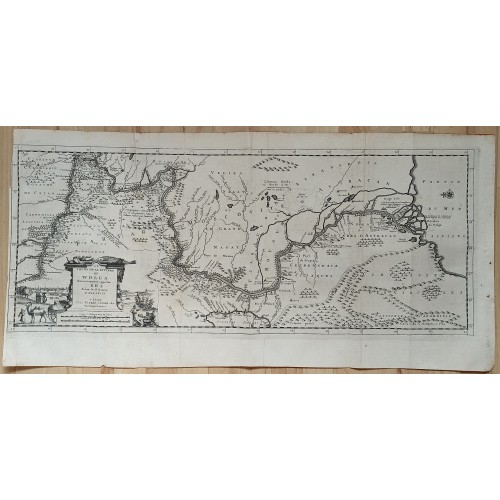
WOLGA RIVER RUSSIA 1719 OLEARIUS & VAN DER AA LARGE ANTIQUE COPPER ENGRAVED MAP
ANTIQUE COPPER ENGRAVED MAP OF THE WOLGA RIVER RUSSIA
WOLGA RIVER RUSSIA 1719 OLEARIUS & VAN DER AA LARGE ANTIQUE COPPER ENGRAVED MAP
Description
Le Cours de la Riviere de Wolga. Anciennement appellйe RHA. Selon la Relation d'Olearius. A Leide, Chez Pierre vander Aa, Marchand Libraire.
Description: Striking and highly decorative unusual 1719 copper engraved map showing the course of the Volga River from Novogorod to its entrance in the Caspian Sea. The map is filled with excellent topographic details on cities, towns, rivers, lakes, forests and reliefs. Embellished with a pictorial cartouche of Russian scenery. Two sheets joined, as issued.
Olearius's map of the lower Volga is the most important map 18th Century map of the River.
Olearius participated in an embassy to Moscow and later to Persia, in an attempt to secure for Frederick III a favorable position at the end of the Silk Route. He travelled extensively in Russia and Persia, meeting with the Czar and the Shah. The party's descent of the Volga resulted in the first detailed mapping of the river and Olearius' account of the expedition, first published in German in 1646 and translated into French in 1656 and again in 1659, is one of the most important early accounts of European travels in Russia.
Olearius map of the Volga is the most accurate 17th century map of the lower Volga river valley, then a key area along Europe's eastern frontier. "There is no comparing Olearius' Volga with those primitive representations seen on earlier maps, such as those of Massa and Visscher" (Bagrow). Olearius' map was quickly copied by Jansson and was widely copied by other makers (with significantly less embellishment and detail) for the next 60+ years. The map is based upon a manuscrip map created by Olearius himself. When he returned to Moscow and presented the map to Czar Michael Romanov, the Czar was offered Olearius a position as court astronomer (which Olearius refused).
Olearius' mission as ambassador was to secure permission to use the Volga as a trade route to Persia, and so his accurate charting of the route was of vital importance. He observed that: "since in my opinion this river is one of the largest, longest and most remarkable in the world, I have explored it assiduously with the help of an expert Dutch navigator, Cornelius Clausen, and some Russian pilots; and reduced it to a map with the aid of compass, showing not only its course, its bends, angles and shores, but also its depths so as to indicate where one can navigate freely and safely, its sand banks, islands in it, and countries along its shores; and I measured the distances in miles and even in versts".
Source: Adam Olearius. Relation du voyage d'Olйarius Adam en Moscovie, Tartarie, et Perse avec celui de I. A. De Mandelslo aux Indes Orientales Traduit de l'Allemand et augmentй par A. de Wicquefort. 1719
Date: 1719 ( undated )
Dimension: Paper size approx.: cm 62,8 x 32,7
Condition: Very strong and dark impression on good paper. Paper with chains and wiremarks. Map uncolored. Wide margin to the top. Wide lower margin. Quite right lateral margin. Wide left lateral margin. Corners partially missing. Small foxing and browning. Sheet folded. Conditions are as you can see in the images.
Translator: Abraham de Wicquefort (Dutch: Abraham van Wickevoort; 24 December 1606 - 23 February 1682) was a Dutch diplomat. Born in Amsterdam, Wicquefort was the brother of Joachim de Wicquefort. Between 1626 and 1658 he represented Brandenburg at the French court, but Cardinal Mazarin imprisoned him in the Bastille as a result of a suspicious exchange of letters. He was released after one year, was given a French pension and settled in the Hague as the representative of the Duchy of Braunschweig-Lьneburg. In 1675 he was put in prison by the Dutch government for treasonous relations with the French. He was given a life-time sentence and his property was confiscated. However, he managed to escape to Celle where he died. Wicquefort translated travel accounts by Adam Olearius and Garcнa de Silva Figueroa's account of an embassy to Persia. He is also the author of L'ambassadeur, ses fonctions (two volumes, 1682) and L'histoire des provinces-unies des Pays-Bas (1719), which discusses the Treaty of Westphalia.
Authors: Johan Albrecht de Mandelslo (1616-1644) was a seventeenth-century German adventurer, who wrote about his travels through Iran (Persia) and India. Born at Schцnberg in Mecklenburg, Germany. After traveling to Isfahan with a diplomatic mission, he separated from the party and made his way to India, where he made interesting observations on the Mughal Empire, then ruled by Shah Jahan. In 1638, Mandelslo visited the ruins at Persepolis in Persia; his name and the year can be found inscribed in the Gate of All Nations at the entrance to the site. Arriving at the port of Surat in April 1638, he moved on to Ahmedabad and Agra. While his observations of life in the capital are useful, he apparently heard nothing about the Taj Mahal, then in its sixth year of construction. The omission may stem from his premature departure from the city, prompted by a chance meeting with the relative of a man he had killed in Persia. Fearing reprisals, he retreated to Lahore before continuing his journey through the empire's southern provinces and travelling on to the Far East. Mandelslo is an engaging and cheerful writer, whose enthusiasm for indiscriminately shooting wildlife (including snakes, buffalo and monkeys) did not endear him to his Indian travelling companions.
Adam Olearius (born Adam Цlschlдger or Oehlschlaeger, 24 September 1599 - 22 February 1671) was a German scholar, mathematician, geographer and librarian. He became secretary to the ambassador sent by Frederick III, Duke of Holstein-Gottorp, to the Shah of Safavid Persia (Iran), and published two books about the events and observations during his travels. He was born at Aschersleben, near Magdeburg. After studying at Leipzig he became librarian and court mathematician to Frederick III, and in 1633 he was appointed secretary to the ambassadors Philipp Crusius, jurisconsult, and Otto Bruggemann, a merchant from Hamburg, sent by the duke to Muscovy and Persia in the hope of making arrangements by which his newly founded city of Friedrichstadt should become the terminus of an overland silk-trade. This embassy started from Gottorp on 22 October 1633 and travelled by Hamburg, Lьbeck, Riga, Dorpat (five months' stay), Reval, Narva, Ladoga, and Novgorod to Moscow (14 August 1634). Here they concluded an advantageous treaty with Tsar Michael of Russia, and returned forthwith to Gottorp (14 December 1634 - 7 April 1635) to procure the ratification of this arrangement from the duke, before proceeding to Persia. With this accomplished, they started afresh from Hamburg on 22 October 1635, arrived at Moscow on 29 March 1636; and left Moscow on 30 June for Balakhna near Nizhniy Novgorod, to where they had already sent agents (in 1634/1635) to prepare a vessel for their descent of the Volga. Their voyage down the great river and over the Caspian Sea was slow and hindered by accidents, especially by grounding, as near Darband on 14 November 1636; but at last, by way of Shamakhy (three months' delay here), Ardabil, Soltaniyeh and Kasvin, they reached the Persian court at Isfahan (3 August 1637) and were received by the Safavid king, Shah Safi (16 August). Negotiations here were not as successful as at Moscow, and the embassy left Isfahan on 21 December 1637, and returned home by Rasht, Lenkoran, Astrakhan, Kazan, Moscow, and other places. At Reval, Olearius parted from his colleagues (15 April 1639) and embarked directly for Lьbeck. On his way he had made a chart of the Volga, and partly for this reason Michael wished to either persuade or compel him to enter his service. Once back at Gottorp, Olearius became librarian to the duke, who also made him keeper of his cabinet of curiosities, and induced the tsar to excuse his (promised) return to Moscow. Under his care the Gottorp library and cabinet were greatly enriched in manuscripts, books, and oriental and other works of art: in 1651 he purchased, for this purpose, the collection of the Dutch scholar and physician, Bernardus Paludanus (born Berent ten Broecke). He died at Gottorp on 22 February 1671.
Cartographer: Pieter van der Aa (1659 - 1733) was a Dutch publisher of maps and atlases active in the late 17th and early 18th centuries. Van der Aa was born in Leyden in 1659. At nine he was apprenticed to a local bookseller and, by 21, had established his own publishing, printing, and auctioneering house. In 1692 Van der Aa was appointed to be one of the High Commissioners of the Booksellers Guild. During his long and impressive career Van der Aa produced thousands of maps, including a vast 28 volume atlas containing no less than 3,000 maps. Few of Van der Aa's maps were original productions, most being copied from the work of earlier cartographers. Nonetheless, when one of Van der Aa's rare original pieces does appear, his style, with unusual projections, elegant engraving, and precise detail, is instantly recognizable and highly desirable. He also pioneered the cartographic idea of separating border artwork from the map plate itself such that every map in a collection could have a similar elaborate border without actually having to re-engrave the complex plates. This technique was used to great effect by later 18th century publishers like Brion de la Tour. Following Van der Aa's death in 1733, his much admired Nouvel Atlas was reissued by the Dutch firm of Covens & Mortier. Today Van der Aa's work is admired for its fine delicate engraving and unusual projections and is considered highly desirable among collectors.
Карта течения реки Волги - антикварная резцовая гравюра на меди, офорт, отпечатана в Лейдене в 1727 году. Первая в истории детальная карта Волги и Поволжья, составленная А. Олеарием на основе собственных наблюдений. Лист из "Описания путешествий в Московию, Татарию и Персию, совершенных Адамом Олеарием", Лейден, Амстердам, 1719
Издатель Питер ван дер Аа - голландский издатель и книготорговец.
Работа из издания Адама Олеария "Описание путешествия в Московию и через Московию в Персию и обратно".
Техника: гравюра на меди (офорт, резец), бумага верже
Издатель: Питер ван дер Аа. Pieter van der Aa (Leiden, 1659-1733)
Географ, историк и математик Адам Олеарий был в 17 веке отправлен с посольством в Москву, а затем в Персию с важной целью - договориться о выгодных условиях торговли вдоль Шелкового пути для шлезвиг-голштинского герцога Фридриха III. Олеарий много путешествовал по России и Персии, встречался с царем и шахом. Результатом этих поездок стала первая подробная карта Волги и рассказ Олеария об экспедиции, опубликованные на немецком языке в 1646 г.
Старая карта Волги Олеария - самая точная карта нижнего течения Волги в 17-го веке. Карта Олеария была вскоре скопирована голландцем Янссоном и широко копировалась другими картографами в течение следующих 60 с лишним лет. Когда Олеарий вернулся из Персии в Москву и представил карту царю Михаилу Романову, ему предложили должность придворного астронома, от которой Олеарий отказался.
Миссия Олеария как посла состояла в том, чтобы получить разрешение использовать Волгу в качестве торгового пути в Персию. Он отмечал, что: «поскольку, по моему мнению, эта река является одной из самых больших, самых длинных и замечательных в мире, я тщательно изучил ее с помощью опытного голландского штурмана Корнелиуса Клаузена и некоторых российских капитанов».
Старая карта также богато иллюстрирована разными видами. Верблюды и татарская повозка появляются на переднем плане, а татарские торговцы выставляют свои товары.
На верхнем картуше надпись: Le Cours de la Riviere de Wolga. Anciennement appellйe RHA. Selon la Relation d'Olearius. A Leide, Chez Pierre vander Aa, Marchand Libraire.
Размер листа: 62,8 x 32,7 см
Предмет музейного уровня в идеальной сохранности. Редкость!
Адам Олеарий (1603-1671) - известный немецкий ученый-математик, профессор Лейпцигского университета, путешественник. Он дважды посетил Россию в 1630-е гг. в качестве секретаря посольства голштинского герцога Фридриха III к русскому царю Михаилу Федоровичу. Во время путешествия Адам Олеарий делал подробные записки, изданные впервые в Шлезвиге в 1647 г.
Является конструктором и куратором создания с 1654 по 1664 года Готторпского глобуса.
Настоящая фамилия Адама - Ольшлегель (Oehlschlegel/Цlschlдger). Он латинизировал её в Olearius.
Будучи секретарём посольства, посланного шлезвиг-голштинским герцогом Фридрихом III к персидскому шаху, записал и опубликовал свои заметки, собранные во время путешествия.
Посольство, в котором принимал участие Олеарий, подробно, день за днем, описано им, и это описание представляет собой одно из замечательнейших литературных явлений XVII века, а вместе с тем, благодаря своей точности, является и одним из важнейших источников для изучения истории России того времени.
Питер ван дер Аа (Pieter van der Aa, 1659-1733) - голландский издатель, владелец книжного магазина и аукционного дома. Известен в первую очередь большим количеством напечатанных карт, как собственных, так и позаимствованных. Питер ван дер Аа начал свою карьеру в Лидене в 1683 году в качестве торговца и издателя, публикующего классические тексты, относящиеся к медицине и точным наукам. После 1700 года ван дер Аа больше специализировался на книгах по географии и путешествиям. Он публиковал составные атласы, серию географических описаний европейских стран и несколько други очень ярких работ. Между 1706 и 1708 годами он опубликовал «Naauweurige versameling der gedenkwaardigste zeeen land-reysen» в 28 томах. Многие публикации Ван дер Аа богато иллюстрированы картами и таблицами. Он перенял многие медные пластины и гравюры других издателей, таких как Карел Аллард и Фредерик Де Вит. Составные атласы, которые появились в его мастерской, содержат любопытную смесь его собственного материала, копий карт других издателей и репринтов, сделанных со старых медных пластин, но уже с его собственным именем. Атлас Galйrie agrйable du monde был завершен в 1729 году и состоял из 66 частей, связанных в 27 томах. Ван дер Аа представил это как хорошее вложение; после публикации ценность произведения должна была удвоится, поскольку оно было напечатано ограниченным тиражом всего в сто экземпляров.
Превосходное состояние. Очень сильный и темный оттиск на хорошей бумаге. Бумага верже с водяными знаками в виде характерной "решетки". Издательский фальц. Левое поле подрезано. Внимательно смотрите состояние на фото.
8250
8250
- Product Code: 8250
- Availability: In Stock
-
$0.00
- Ex Tax: $0.00