
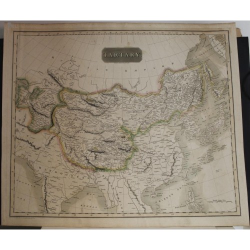
CHINA KOREAN PENINSULA MONGOLIA TIBET CENTRAL ASIA 1814 THOMSON ANTIQUE MAP
US $26.55
This fascinating hand colored 1814 map of central and East Asia, covering southern Tartary, Tibet (Tibet), Mongolia, and generally the whole of Central Asia. The area is named after the 'Tartars,' the Turkic and Mongol peoples of the Mongol Empire. The region covered extends from the Caspian Sea to Japan and Korea.
Politically this map is configured roughly along the lines of the old Mongol Empire, with the territories controlled by the sons of Kublai Khan, based in Peking, defined as Chinese Tartary, and the territory to the west of Kashgar, modern day Kazakhstan, Uzbekistan, and Turkmenistan, occupied by various independent 'Hordes,' including the Great Horde, the Kirguses Hordes, and the Kharizm. The supposed site of the ancient capital of the Great Khan, Karakum, is noted in the Gobi. A portion of the ancient Silk Route caravan from Lok Nor to China is noted along with various caravan stops along the way. The cities of Bokhara, Kashgar, and Samarkand are also noted.
The sea between Japan and Korea, whose historic name is currently a matter of dispute between the two countries, is identified as the Sea of Japan. Magnificent size, beautiful color, and high detail make this one of the finest maps of these central Asian nations to appear in the early 19th century. The whole is beautifully engraved in the minimalist English style pioneered in the early part of the 19th century. Relief is shown by hachure with towns, cities, and major topographical features identified.
This map is a steel plate engraving and was issues as plate no. 37 in Edinburgh cartographer John Thomson's 1817 New General Atlas.
John Thomson (1777 - c. 1841) was a Scottish cartographer, publisher, and bookbinder active in Edinburgh during the early part of the 19th century. Thomson apprenticed under Edinburgh bookbinder Robert Alison. After his apprenticeship he briefly went into business with Abraham Thomson. Later the two parted ways, John Thomson segueing into maps and Abraham Thomson taking over the bookbinding portion of the business. Thomson is generally one of the leading publishers in the Edinburgh school of cartography which flourished from roughly 1800 to 1830. Thomson and his contemporaries (Pinkerton and Cary) redefined European cartography by abandoning typical 18th century decorative elements such as elaborate title cartouches and fantastic beasts in favor of detail and accuracy. Thomson's principle works include Thomson's New General Atlas, published from 1814 to 1821, the New Classical and Historical Atlas of 1829, and his 1830 Atlas of Scotland. The Atlas of Scotland, a work of groundbreaking detail and dedication would eventually bankrupt the Thomson firm in 1830, at which time their plates were sequestered by the court. The firm partially recovered in the subsequent year allowing Thomson to reclaim his printing plates in 1831, but filed again for bankruptcy in 1835, at which time most of his printing plates were sold to A. K. Johnston and Company. There is some suggestion that he continued to work as a bookbinder until 1841. Today, Thomson maps are becoming increasingly rare as they are highly admired for their impressive size, vivid hand coloration, and superb detail. More by this mapmaker...
SOURCE
Thomson, J., A New General Atlas, (Edinburgh) 1814. Thomson's New General Atlas was first published in 1817 and continued to be published until about 1821. This is the first of Thomson's major cartographic works and the atlas for which is most celebrated. The New General Atlas follows in the Edinburgh School, which eschews excessive decoration in favor of a more minimalistic fact-based cartographic vision, as established by John Pinkerton, Laurie and Whittle, John Cary, and others in the previous decades. The maps are notable for their massive scale, heavy stock, elegant color work, and easy-to-read typefaces. Although the atlas stopped being published after 1821, Thomson continued to offer 'supplementary' maps that could be tipped into the atlas as late as 1830, when he declared bankruptcy. The maps in the Thomson Atlas were engraved by Thomas Clerk, William Dassauville, Nathaniel Rogers Hewitt, James Kirkwood, Robert Kirkwood, John Menzies, George Menzies, Edward Mitchell, John Moffatt, Samuel John Neele, Robert Scott, and James Wyld.
CONDITION
Very good. Minor wear and verso repair along original centerfold. Minor foxing at places. Original platemark visible.
REFERENCES
Rumsey 1007.040. Phillips (Atlases) 731. Newberry Library: Ayer 135 T4 1817.
Оригинальная раскрашенная вручную карта Центральной и Восточной Азии 1814 года, охватывающая южную Татарию, Тибет (Тибет), Монголию и в целом всю Центральную Азию. Район назван в честь «татар», тюркских и монгольских народов Монгольской империи. Охватываемый регион простирается от Каспийского моря до Японии и Кореи.
Политически эта карта построена примерно по образцу старой Монгольской империи, с территориями, контролируемыми сыновьями Хубилай-хана, базирующимися в Пекине, определяемыми как Китайская Тартария, и территорией к западу от Кашгара (современный Казахстан, Узбекистан, и Туркменистан, оккупированный различными независимыми «ордами», включая Великую Орду, Киргусские орды и Харизм. В Гоби отмечено предполагаемое местонахождение древней столицы Великого хана Каракумов. Отмечается часть древнего каравана Шелкового пути от Лок Нора до Китая, а также различные остановки караванов на этом пути. Также отмечены города Бухара, Кашгар и Самарканд.
Море между Японией и Кореей, историческое название которого в настоящее время является предметом спора между двумя странами, идентифицируется как Японское море. Великолепный размер, красивый цвет и высокая детализация делают эту карту одной из лучших карт этих центральноазиатских стран, появившихся в начале XIX века. Все это красиво выгравировано в английском минималистском стиле, впервые появившемся в начале 19 века. Рельеф показан штриховкой с обозначением городов, поселков и основных топографических объектов.
Эта карта представляет собой гравюру -оттиск со стальной пластине - и была издана под номером пластины. 37 в «Новом общем атласе» (New General Atlas) эдинбургского картографа Джона Томсона (John Thomson)1817 года.
Джон Томсон (1777 – ок. 1841) был шотландским картографом, издателем и переплетчиком, работавшим в Эдинбурге в начале XIX века.
Томсон являлся одним из ведущих издателей Эдинбургской картографической школы, которая процветала примерно с 1800 по 1830 год.
Томсон и его современники (Пинкертон и Кэри) изменили определение европейской картографии, отказавшись от типичных декоративных элементов 18-го века, таких как сложные заглавные картуши и фантастические звери на рисунках. предпочтение детализации и точности. Сегодня карты Томсона становятся все более редкими, поскольку они вызывают большое восхищение за их впечатляющий размер, яркую окраску рук и превосходную детализацию.
Новый общий атлас Томсона был впервые опубликован в 1817 году и продолжал публиковаться примерно до 1821 года. Это первая из крупных картографических работ Томсона и атлас, получивший наибольшую известность.
Новый Общий Атлас следует примеру Эдинбургской школы, которая избегает чрезмерного украшения в пользу более минималистичного картографического видения, основанного на фактах, как это было установлено Джоном Пинкертоном, Лори и Уиттлом, Джоном Кэри и другими в предыдущие десятилетия.
Карты отличаются огромным масштабом, большим объемом, элегантной цветопередачей и легко читаемыми шрифтами. Хотя атлас перестал публиковаться после 1821 года, Томсон продолжал предлагать «дополнительные» карты, которые можно было добавить в атлас даже в 1830 году, когда он объявил о своем банкротстве.
Карты в Атласе Томсона были гравированы Томасом Клерком, Уильямом Дассавилем, Натаниэлем Роджерсом Хьюиттом, Джеймсом Кирквудом, Робертом Кирквудом, Джоном Мензисом, Джорджем Мензисом, Эдвардом Митчеллом, Джоном Моффаттом, Сэмюэлем Джоном Нилом, Робертом Скоттом и Джеймсом Уайлдом.
REFERENCES: Rumsey 1007.040. Phillips (Atlases) 731. Newberry Library: Ayer 135 T4 1817.
7607
7607
- Product Code: 7607
- Availability: In Stock
-
$0.00
- Ex Tax: $0.00