
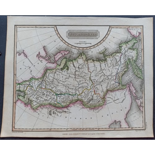
RUSSIA 1827 ARROWSMITH UNUSUAL ANTIQUE COLORED LITHOGRAPHIC MAP
ANTIQUE ORIGINAL LITHOGRAPHIC MAP OF RUSSIA IN ASIA
Condition:
--not specified
Ended:
Dec 11, 2023 21:05:33 PST
Winning bid:
US $17.50
Russia in Asia.
До покупки уточняйте, пожалуйста, наличие и сроки доставки!!
Яркая и очень подробная подлинная цветная литографическая карта России в Азии 1823 года. На карте отмечены города, поселки, реки, заливы, озера, острова и рельефы. Картуш с названием карты и шкала масштаба дополняют карту.
Отличный подарок солидному человеку!!
Год: 1823 (датированная)
Техника: гравюра на стали, бумага, ручная акварельная раскраска
Размер листа (см): 28,5 x 23
Обратная сторона чистая
Оригинальное название: "Rossia in Asia"
Карта из атласа A New General Atlas Constructed, составленного A. Arrowsnith,. Лондон. Издано Longman Rees Orme Brown & Green. Патерностер Роу. 1823.
Очень сильный и темный оттиск на хорошей плотной бумаге. Состояние вы можете видеть на фотографиях.
Карта имеет историко-географическое, культурное и художественное значение, её отличает прекрасная техника гравирования, эффектность, особая декоративность. Прекрасное коллекционное состояние, оттиск яркий и четкий.
Старинная карта обладает антикварной, художественной и коллекционной ценностью, и будет великолепным подарком коллекционеру, неповторимым украшением интерьера.
Description: Striking and highly detailed interesting 1827 original colored lithographic map of Russia in Asia. Notes cities, towns, rivers, bays, lakes, islands and reliefs. A title cartouche and a mileage scale complete the map.
Source: A New General Atlas Constructed by A. Arrowsnith, Geographer to the King Exhibiting The Boundaries and Divisions. Chains of Montains and other Geographical Features of all the Know Countries in the Worls. London Published by Longman Rees Orme Brown & Green. Paternoster Row. 1827.
Date: 1827( undated )
Dimension: Paper size approx.: cm 28,5 x 22,8
Condition: Very strong and dark impression on good paper. Sheet old original colored. Small foxing and browning. Conditions are as you can see in the images.
Mapmaker: Aaron Arrowsmith (1750-1823), John Arrowsmith (1790-1873), and Samuel Arrowsmith. The Arrowsmith family were noted map engravers, publishers, geographers, and cartographers active in the late 18th and early 19th century. The Arrowsmith firm was founded by Aaron Arrowsmith, who was trained in surveying and engraving under John Cary and William Faden. Arrowsmith founded the Arrowsmith firm as a side business while employed by Cary. The firm specialized in large format individual issue maps containing the most up to date and sophisticated information available. Arrowsmith's work drew the attention of the Prince of Wales who, in 1810, named him Hydrographer to the Prince of Wales, and subsequently, in 1820, Hydrographer to the King. Aaron Arrowsmith was succeeded by two sons, Aaron and Samuel, who followed him in the map publication business. The Arrowsmith firm eventually fell to John Arrowsmith (1790-1873), nephew of the elder Aaron. John was a founding member of the Royal Geographical Society. The firm is best known for their phenomenal large format mappings of North America. Mount Arrowsmith, situated east of Port Alberni on Vancouver Island, British Columbia, is named for Aaron Arrowsmith and his nephew John Arrowsmith.
5827
- Product Code: 5827
- Availability: In Stock
-
$0.00
- Ex Tax: $0.00